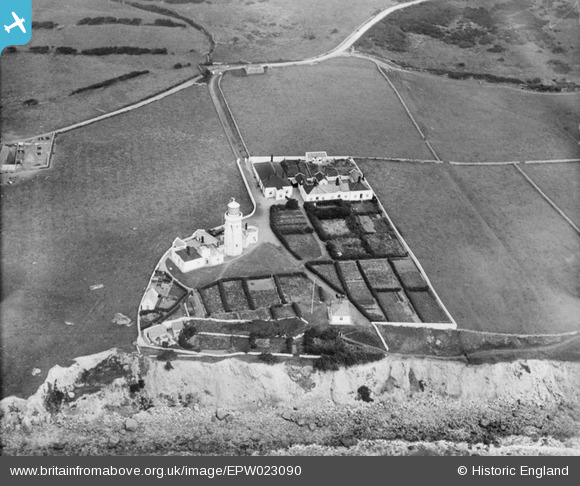
EPW023090 ENGLAND (1928). St. Catherine's Lighthouse, St Catherine's Point, 1928
© Hawlfraint cyfranwyr OpenStreetMap a thrwyddedwyd gan yr OpenStreetMap Foundation. 2024. Trwyddedir y gartograffeg fel CC BY-SA.
Delweddau cyfagos (9)
Manylion
| Pennawd | [EPW023090] St. Catherine's Lighthouse, St Catherine's Point, 1928 |
| Cyfeirnod | EPW023090 |
| Dyddiad | August-1928 |
| Dolen | |
| Enw lle | ST CATHERINE'S POINT |
| Plwyf | NITON AND WHITWELL |
| Ardal | |
| Gwlad | ENGLAND |
| Dwyreiniad / Gogleddiad | 449834, 75351 |
| Hydred / Lledred | -1.2961427598117, 50.575182620091 |
| Cyfeirnod Grid Cenedlaethol | SZ498754 |
Pinnau
Cyfraniadau Grŵp
This lighthouse dates from 1840. It was originally 120 ft high. Fog adversely affected the light and the tower was reduced in height in 1875. It is said to be the third most powerful light in the Trinity House estate |
 MB |
Monday 29th of October 2012 02:20:22 PM |


![[EPW023090] St. Catherine's Lighthouse, St Catherine's Point, 1928](http://britainfromabove.org.uk/sites/all/libraries/aerofilms-images/public/100x100/EPW/023/EPW023090.jpg)
![[EPW000798] St Catherine's Lighthouse, St Catherine's Point, 1920](http://britainfromabove.org.uk/sites/all/libraries/aerofilms-images/public/100x100/EPW/000/EPW000798.jpg)
![[EAW038598] Knowles Farm and St Catherine's Lighthouse, St Catherine's Point, 1951. This image has been produced from a print.](http://britainfromabove.org.uk/sites/all/libraries/aerofilms-images/public/100x100/EAW/038/EAW038598.jpg)
![[EPW023086] St Catherine's Lighthouse and Knowles, St Catherine's Point, 1928](http://britainfromabove.org.uk/sites/all/libraries/aerofilms-images/public/100x100/EPW/023/EPW023086.jpg)
![[EPW023087] St Catherine's Lighthouse, St Catherine's Point, 1928](http://britainfromabove.org.uk/sites/all/libraries/aerofilms-images/public/100x100/EPW/023/EPW023087.jpg)
![[EPW000504] St Catherine's Lighthouse, St Catherine's Point, Isle of Wight, 1920](http://britainfromabove.org.uk/sites/all/libraries/aerofilms-images/public/100x100/EPW/000/EPW000504.jpg)
![[EPW039632] St Catherine's Lighthouse and the coastline, St Catherine's Point, from the south-west, 1932](http://britainfromabove.org.uk/sites/all/libraries/aerofilms-images/public/100x100/EPW/039/EPW039632.jpg)
![[EAW038599] Knowles Farm, St Catherine's Lighthouse and the surrounding area, St Catherine's Point, from the south-west, 1951. This image has been produced from a print.](http://britainfromabove.org.uk/sites/all/libraries/aerofilms-images/public/100x100/EAW/038/EAW038599.jpg)
![[EPW000506] St Catherine's Lighthouse, St Catherine's Point, Isle of Wight, from the south, 1920](http://britainfromabove.org.uk/sites/all/libraries/aerofilms-images/public/100x100/EPW/000/EPW000506.jpg)