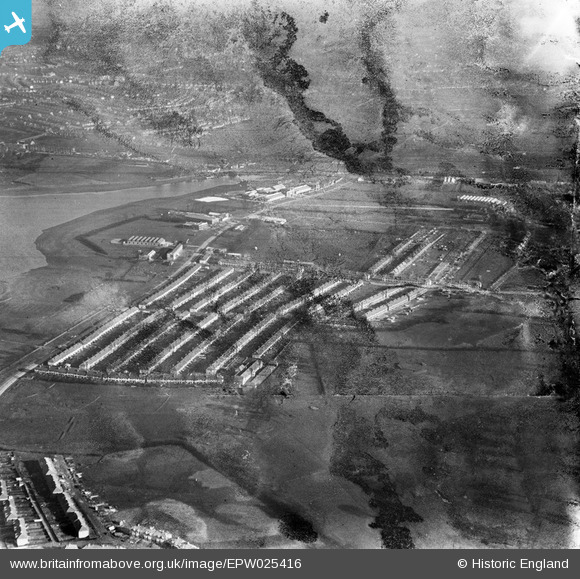
EPW025416 ENGLAND (1928). A new housing estate on the North Circular Road by the Brent Reservoir, Dollis Hill, 1928. This image has been produced from a damaged negative.
© Hawlfraint cyfranwyr OpenStreetMap a thrwyddedwyd gan yr OpenStreetMap Foundation. 2025. Trwyddedir y gartograffeg fel CC BY-SA.
Delweddau cyfagos (12)
Manylion
| Pennawd | [EPW025416] A new housing estate on the North Circular Road by the Brent Reservoir, Dollis Hill, 1928. This image has been produced from a damaged negative. |
| Cyfeirnod | EPW025416 |
| Dyddiad | 9-November-1928 |
| Dolen | |
| Enw lle | DOLLIS HILL |
| Plwyf | |
| Ardal | |
| Gwlad | ENGLAND |
| Dwyreiniad / Gogleddiad | 522006, 186799 |
| Hydred / Lledred | -0.23952138206064, 51.566373500316 |
| Cyfeirnod Grid Cenedlaethol | TQ220868 |
Pinnau
Byddwch y cyntaf i ychwanegu sylw at y ddelwedd hon!


![[EPW025416] A new housing estate on the North Circular Road by the Brent Reservoir, Dollis Hill, 1928. This image has been produced from a damaged negative.](http://britainfromabove.org.uk/sites/all/libraries/aerofilms-images/public/100x100/EPW/025/EPW025416.jpg)
![[EPW025415] A new housing estate on the North Circular Road by the Brent Reservoir, Dollis Hill, 1928. This image has been produced from a damaged negative.](http://britainfromabove.org.uk/sites/all/libraries/aerofilms-images/public/100x100/EPW/025/EPW025415.jpg)
![[EPW021257] A housing estate under construction at Heather Road, Dollis Hill, 1928](http://britainfromabove.org.uk/sites/all/libraries/aerofilms-images/public/100x100/EPW/021/EPW021257.jpg)
![[EPW025412] A new housing estate on the North Circular Road by the Brent Reservoir, Dollis Hill, 1928](http://britainfromabove.org.uk/sites/all/libraries/aerofilms-images/public/100x100/EPW/025/EPW025412.jpg)
![[EPW025411] A new housing estate on the North Circular Road by the Brent Reservoir, Dollis Hill, 1928. This image has been produced from a damaged negative.](http://britainfromabove.org.uk/sites/all/libraries/aerofilms-images/public/100x100/EPW/025/EPW025411.jpg)
![[EPW025410] A new housing estate on the North Circular Road by the Brent Reservoir, Dollis Hill, 1928. This image has been produced from a damaged negative.](http://britainfromabove.org.uk/sites/all/libraries/aerofilms-images/public/100x100/EPW/025/EPW025410.jpg)
![[EPW032178] The Jaeger Clock Works on the North Circular Road, Dollis Hill, 1930](http://britainfromabove.org.uk/sites/all/libraries/aerofilms-images/public/100x100/EPW/032/EPW032178.jpg)
![[EPW025396] A new housing estate on the North Circular Road by the Brent Reservoir, Dollis Hill, 1928. This image has been produced from a damaged negative.](http://britainfromabove.org.uk/sites/all/libraries/aerofilms-images/public/100x100/EPW/025/EPW025396.jpg)
![[EPW055816] Industrial units including the Clayton Mayers and Co Glassware Works alongside the North Circular Road, Dollis Hill, 1937](http://britainfromabove.org.uk/sites/all/libraries/aerofilms-images/public/100x100/EPW/055/EPW055816.jpg)
![[EPW025414] A new housing estate on the North Circular Road by the Brent Reservoir, Dollis Hill, 1928. This image has been produced from a damaged negative.](http://britainfromabove.org.uk/sites/all/libraries/aerofilms-images/public/100x100/EPW/025/EPW025414.jpg)
![[EPW025399] A new housing estate on the North Circular Road by the Brent Reservoir, Dollis Hill, 1928. This image has been produced from a damaged negative.](http://britainfromabove.org.uk/sites/all/libraries/aerofilms-images/public/100x100/EPW/025/EPW025399.jpg)
![[EPW025413] A new housing estate on the North Circular Road by the Brent Reservoir, Dollis Hill, from the south-east, 1928. This image has been produced from a damaged negative.](http://britainfromabove.org.uk/sites/all/libraries/aerofilms-images/public/100x100/EPW/025/EPW025413.jpg)