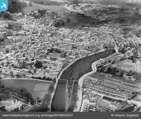
EPW026537 ENGLAND (1929). The town centre, Kendal, from the south-east, 1929
© Hawlfraint cyfranwyr OpenStreetMap a thrwyddedwyd gan yr OpenStreetMap Foundation. 2025. Trwyddedir y gartograffeg fel CC BY-SA.
Delweddau cyfagos (9)
Manylion
| Pennawd | [EPW026537] The town centre, Kendal, from the south-east, 1929 |
| Cyfeirnod | EPW026537 |
| Dyddiad | May-1929 |
| Dolen | |
| Enw lle | KENDAL |
| Plwyf | KENDAL |
| Ardal | |
| Gwlad | ENGLAND |
| Dwyreiniad / Gogleddiad | 351702, 492352 |
| Hydred / Lledred | -2.7426789024017, 54.324304032469 |
| Cyfeirnod Grid Cenedlaethol | SD517924 |
Pinnau
 Benny boy |
Sunday 17th of November 2013 11:57:00 PM | |
 Maurice |
Tuesday 11th of June 2013 07:36:08 PM | |
 Maurice |
Tuesday 11th of June 2013 07:35:34 PM | |
 MB |
Wednesday 12th of September 2012 10:49:18 PM | |
 MB |
Wednesday 12th of September 2012 10:48:41 PM | |
 MB |
Wednesday 12th of September 2012 10:47:46 PM | |
 MB |
Wednesday 12th of September 2012 10:44:50 PM | |
 MB |
Wednesday 12th of September 2012 10:43:46 PM | |
 MB |
Wednesday 12th of September 2012 10:43:00 PM | |
 MB |
Wednesday 12th of September 2012 10:40:54 PM | |
 MB |
Wednesday 12th of September 2012 10:40:28 PM | |
 MB |
Wednesday 12th of September 2012 10:39:41 PM | |
 MB |
Wednesday 12th of September 2012 10:39:03 PM | |
 JohnA |
Friday 20th of July 2012 10:56:24 AM |


![[EPW026537] The town centre, Kendal, from the south-east, 1929](http://britainfromabove.org.uk/sites/all/libraries/aerofilms-images/public/100x100/EPW/026/EPW026537.jpg)
![[EPW026540] Castle Carpet and Rug Mills, Kendal, 1929. This image has been affecetd by flare.](http://britainfromabove.org.uk/sites/all/libraries/aerofilms-images/public/100x100/EPW/026/EPW026540.jpg)
![[EAW014500] The town, Kendal, from the north-east, 1948](http://britainfromabove.org.uk/sites/all/libraries/aerofilms-images/public/100x100/EAW/014/EAW014500.jpg)
![[EPW026541] Holy Trinity Church, Abbott Hall and the Recreation Ground, Kendal, 1929](http://britainfromabove.org.uk/sites/all/libraries/aerofilms-images/public/100x100/EPW/026/EPW026541.jpg)
![[EPW026538] The town centre, Kendal, from the south, 1929](http://britainfromabove.org.uk/sites/all/libraries/aerofilms-images/public/100x100/EPW/026/EPW026538.jpg)
![[EPW038829] Highgate and the town centre, Kendal, from the south, 1932](http://britainfromabove.org.uk/sites/all/libraries/aerofilms-images/public/100x100/EPW/038/EPW038829.jpg)
![[EPW038828] Miller Field and the town centre, Kendal, 1932](http://britainfromabove.org.uk/sites/all/libraries/aerofilms-images/public/100x100/EPW/038/EPW038828.jpg)
![[EAW043385] The town, Kendal, 1952](http://britainfromabove.org.uk/sites/all/libraries/aerofilms-images/public/100x100/EAW/043/EAW043385.jpg)
![[EAW043384] The town, Kendal, 1952](http://britainfromabove.org.uk/sites/all/libraries/aerofilms-images/public/100x100/EAW/043/EAW043384.jpg)