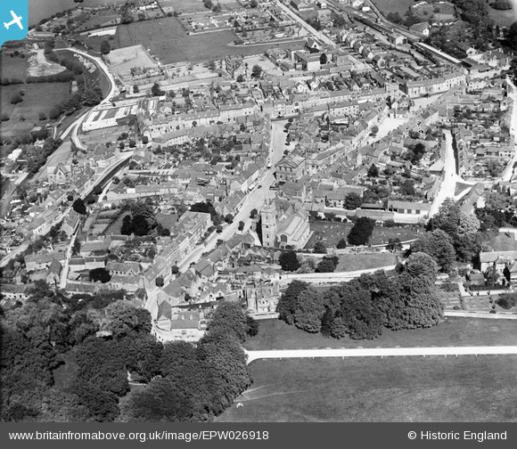
EPW026918 ENGLAND (1929). St Mary's Church and the town centre, Woodstock, 1929
© Hawlfraint cyfranwyr OpenStreetMap a thrwyddedwyd gan yr OpenStreetMap Foundation. 2025. Trwyddedir y gartograffeg fel CC BY-SA.
Delweddau cyfagos (8)
Manylion
| Pennawd | [EPW026918] St Mary's Church and the town centre, Woodstock, 1929 |
| Cyfeirnod | EPW026918 |
| Dyddiad | May-1929 |
| Dolen | |
| Enw lle | WOODSTOCK |
| Plwyf | WOODSTOCK |
| Ardal | |
| Gwlad | ENGLAND |
| Dwyreiniad / Gogleddiad | 444389, 216742 |
| Hydred / Lledred | -1.3555349418235, 51.847066068381 |
| Cyfeirnod Grid Cenedlaethol | SP444167 |
Pinnau
 ndaisley |
Wednesday 4th of September 2013 09:00:43 PM |
Cyfraniadau Grŵp
In fact, the 'Union Workhouse', demolished in 1969 - http://www.workhouses.org.uk/Woodstock/ |
 ndaisley |
Tuesday 10th of September 2013 06:53:17 PM |


![[EPW026918] St Mary's Church and the town centre, Woodstock, 1929](http://britainfromabove.org.uk/sites/all/libraries/aerofilms-images/public/100x100/EPW/026/EPW026918.jpg)
![[EPW026922] St Mary's Church and the town centre, Woodstock, 1929](http://britainfromabove.org.uk/sites/all/libraries/aerofilms-images/public/100x100/EPW/026/EPW026922.jpg)
![[EPW026916] St Mary's Church and the town centre, Woodstock, 1929](http://britainfromabove.org.uk/sites/all/libraries/aerofilms-images/public/100x100/EPW/026/EPW026916.jpg)
![[EAW014902] The village, Woodstock, from the south-west, 1948. This image has been produced from a print.](http://britainfromabove.org.uk/sites/all/libraries/aerofilms-images/public/100x100/EAW/014/EAW014902.jpg)
![[EPW026917] The town centre, Woodstock, 1929](http://britainfromabove.org.uk/sites/all/libraries/aerofilms-images/public/100x100/EPW/026/EPW026917.jpg)
![[EPW026919] The town centre, Woodstock, 1929](http://britainfromabove.org.uk/sites/all/libraries/aerofilms-images/public/100x100/EPW/026/EPW026919.jpg)
![[EPW026915] Woodstock House and environs, Woodstock, 1929](http://britainfromabove.org.uk/sites/all/libraries/aerofilms-images/public/100x100/EPW/026/EPW026915.jpg)
![[EPW026921] The town, Woodstock, from the south-west, 1929](http://britainfromabove.org.uk/sites/all/libraries/aerofilms-images/public/100x100/EPW/026/EPW026921.jpg)