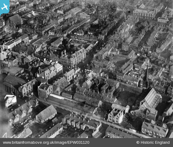
EPW031120 ENGLAND (1929). The junction of King Street and Bradshawgate and surroundings, Leigh, 1929
© Hawlfraint cyfranwyr OpenStreetMap a thrwyddedwyd gan yr OpenStreetMap Foundation. 2025. Trwyddedir y gartograffeg fel CC BY-SA.
Delweddau cyfagos (6)
Manylion
| Pennawd | [EPW031120] The junction of King Street and Bradshawgate and surroundings, Leigh, 1929 |
| Cyfeirnod | EPW031120 |
| Dyddiad | October-1929 |
| Dolen | |
| Enw lle | LEIGH |
| Plwyf | |
| Ardal | |
| Gwlad | ENGLAND |
| Dwyreiniad / Gogleddiad | 365662, 400085 |
| Hydred / Lledred | -2.5176691097241, 53.496095169096 |
| Cyfeirnod Grid Cenedlaethol | SD657001 |
Pinnau
 gh |
Sunday 6th of June 2021 08:21:58 PM | |
 gh |
Sunday 6th of June 2021 08:13:20 PM | |
 wiganer |
Tuesday 15th of November 2016 06:46:37 PM | |
 DFoxwell |
Friday 11th of April 2014 07:11:14 PM | |
 DFoxwell |
Friday 11th of April 2014 07:08:05 PM | |
 DFoxwell |
Friday 11th of April 2014 07:06:23 PM | |
 SMJ |
Wednesday 5th of December 2012 03:06:27 PM |


![[EPW031120] The junction of King Street and Bradshawgate and surroundings, Leigh, 1929](http://britainfromabove.org.uk/sites/all/libraries/aerofilms-images/public/100x100/EPW/031/EPW031120.jpg)
![[EPW055097] King Street, Bradshawgate and the town centre, Leigh, 1937](http://britainfromabove.org.uk/sites/all/libraries/aerofilms-images/public/100x100/EPW/055/EPW055097.jpg)
![[EPW031121] Cook Street and surroundings, Leigh, 1929](http://britainfromabove.org.uk/sites/all/libraries/aerofilms-images/public/100x100/EPW/031/EPW031121.jpg)
![[EPW055092] Market Street, Broadshawgate and the town centre, Leigh, 1937](http://britainfromabove.org.uk/sites/all/libraries/aerofilms-images/public/100x100/EPW/055/EPW055092.jpg)
![[EPW031118] The King Street Methodist Church and surroundings, Leigh, 1929](http://britainfromabove.org.uk/sites/all/libraries/aerofilms-images/public/100x100/EPW/031/EPW031118.jpg)
![[EPW031122] St Mary's Church, Leigh, 1929](http://britainfromabove.org.uk/sites/all/libraries/aerofilms-images/public/100x100/EPW/031/EPW031122.jpg)
