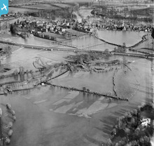
EPW031209 ENGLAND (1929). The River Thames flood covering South Field, the Eton Railway Viaduct and South Meadow, Eton, 1929
© Hawlfraint cyfranwyr OpenStreetMap a thrwyddedwyd gan yr OpenStreetMap Foundation. 2024. Trwyddedir y gartograffeg fel CC BY-SA.
Manylion
| Pennawd | [EPW031209] The River Thames flood covering South Field, the Eton Railway Viaduct and South Meadow, Eton, 1929 |
| Cyfeirnod | EPW031209 |
| Dyddiad | December-1929 |
| Dolen | |
| Enw lle | ETON |
| Plwyf | ETON |
| Ardal | |
| Gwlad | ENGLAND |
| Dwyreiniad / Gogleddiad | 495803, 177564 |
| Hydred / Lledred | -0.619994217261, 51.488414308501 |
| Cyfeirnod Grid Cenedlaethol | SU958776 |
Pinnau
 Ellensdottir |
Sunday 10th of November 2013 04:13:32 PM | |
 Ellensdottir |
Sunday 10th of November 2013 04:12:29 PM | |
 Ellensdottir |
Sunday 10th of November 2013 04:11:46 PM | |
 Ellensdottir |
Sunday 10th of November 2013 04:10:43 PM | |
 Ellensdottir |
Sunday 10th of November 2013 04:09:55 PM | |
 Ellensdottir |
Sunday 10th of November 2013 04:07:22 PM | |
 Ellensdottir |
Sunday 10th of November 2013 04:01:52 PM | |
 Ellensdottir |
Sunday 10th of November 2013 03:58:34 PM | |
 Ellensdottir |
Sunday 10th of November 2013 03:57:37 PM | |
 dave43 |
Tuesday 10th of September 2013 09:36:19 PM | |
 flubber |
Tuesday 20th of November 2012 05:27:07 PM |


![[EPW031209] The River Thames flood covering South Field, the Eton Railway Viaduct and South Meadow, Eton, 1929](http://britainfromabove.org.uk/sites/all/libraries/aerofilms-images/public/100x100/EPW/031/EPW031209.jpg)
![[EPW022602] Windsor Railway Bridge and Baths Island, Windsor, 1928](http://britainfromabove.org.uk/sites/all/libraries/aerofilms-images/public/100x100/EPW/022/EPW022602.jpg)
