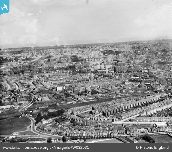
EPW032531 ENGLAND (1930). Housing at Windmill Hill and the city, Bristol, from the south-east, 1930
© Hawlfraint cyfranwyr OpenStreetMap a thrwyddedwyd gan yr OpenStreetMap Foundation. 2025. Trwyddedir y gartograffeg fel CC BY-SA.
Delweddau cyfagos (9)
Manylion
| Pennawd | [EPW032531] Housing at Windmill Hill and the city, Bristol, from the south-east, 1930 |
| Cyfeirnod | EPW032531 |
| Dyddiad | June-1930 |
| Dolen | |
| Enw lle | BRISTOL |
| Plwyf | |
| Ardal | |
| Gwlad | ENGLAND |
| Dwyreiniad / Gogleddiad | 358562, 171277 |
| Hydred / Lledred | -2.5962370572181, 51.438480965731 |
| Cyfeirnod Grid Cenedlaethol | ST586713 |
Pinnau
 teadog |
Saturday 3rd of February 2018 11:36:20 PM | |
 teadog |
Saturday 3rd of February 2018 11:35:48 PM | |
 teadog |
Saturday 3rd of February 2018 11:35:20 PM | |
 Hillzider |
Thursday 7th of March 2013 12:06:18 PM | |
 kent2 |
Wednesday 12th of December 2012 11:44:25 AM | |
 kent2 |
Wednesday 12th of December 2012 11:42:56 AM | |
 kent2 |
Wednesday 12th of December 2012 11:42:23 AM | |
 kent2 |
Wednesday 12th of December 2012 11:41:18 AM | |
 kent2 |
Wednesday 12th of December 2012 11:40:16 AM | |
 kent2 |
Wednesday 12th of December 2012 11:39:28 AM | |
 kent2 |
Wednesday 12th of December 2012 11:38:41 AM |
Cyfraniadau Grŵp
Beautiful photograph but of poor quality. Must be a disappointment to older generation Bristolians of which, at the age of 75 years, I am one. |
 kent2 |
Wednesday 12th of December 2012 11:50:09 AM |


![[EPW032531] Housing at Windmill Hill and the city, Bristol, from the south-east, 1930](http://britainfromabove.org.uk/sites/all/libraries/aerofilms-images/public/100x100/EPW/032/EPW032531.jpg)
![[EAW032248] The E. S. & A. Robinson Printing and Stationery Works on St John's Street, Ashton Gate, 1950. This image was marked by Aerofilms Ltd for photo editing.](http://britainfromabove.org.uk/sites/all/libraries/aerofilms-images/public/100x100/EAW/032/EAW032248.jpg)
![[EAW032250] East Street, the E. S. & A. Robinson Printing and Stationery Works on St John's Street and environs, Ashton Gate, 1950. This image was marked by Aerofilms Ltd for photo editing.](http://britainfromabove.org.uk/sites/all/libraries/aerofilms-images/public/100x100/EAW/032/EAW032250.jpg)
![[EAW032246] The E. S. & A. Robinson Printing and Stationery Works on St John's Street and environs, Ashton Gate, 1950. This image was marked by Aerofilms Ltd for photo editing.](http://britainfromabove.org.uk/sites/all/libraries/aerofilms-images/public/100x100/EAW/032/EAW032246.jpg)
![[EAW032253] The E. S. & A. Robinson Printing and Stationery Works on St John's Street and environs, Ashton Gate, 1950. This image was marked by Aerofilms Ltd for photo editing.](http://britainfromabove.org.uk/sites/all/libraries/aerofilms-images/public/100x100/EAW/032/EAW032253.jpg)
![[EAW032247] The E. S. & A. Robinson Printing and Stationery Works on St John's Street, Ashton Gate, 1950. This image was marked by Aerofilms Ltd for photo editing.](http://britainfromabove.org.uk/sites/all/libraries/aerofilms-images/public/100x100/EAW/032/EAW032247.jpg)
![[EAW032249] East Street, the E. S. & A. Robinson Printing and Stationery Works on St John's Street and environs, Ashton Gate, 1950. This image was marked by Aerofilms Ltd for photo editing.](http://britainfromabove.org.uk/sites/all/libraries/aerofilms-images/public/100x100/EAW/032/EAW032249.jpg)
![[EAW032251] The E. S. & A. Robinson Printing and Stationery Works and environs, Ashton Gate, 1950. This image was marked by Aerofilms Ltd for photo editing.](http://britainfromabove.org.uk/sites/all/libraries/aerofilms-images/public/100x100/EAW/032/EAW032251.jpg)
![[EAW032252] East Street, the E. S. & A. Robinson Printing and Stationery Works on St John's Street and environs, Ashton Gate, 1950. This image was marked by Aerofilms Ltd for photo editing.](http://britainfromabove.org.uk/sites/all/libraries/aerofilms-images/public/100x100/EAW/032/EAW032252.jpg)