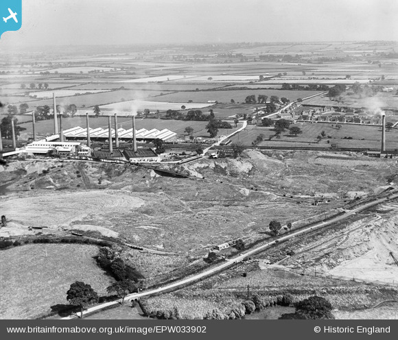
EPW033902 ENGLAND (1930). The Pillinge Brickworks and Wootton Pillinge, Stewartby, from the west, 1930
© Hawlfraint cyfranwyr OpenStreetMap a thrwyddedwyd gan yr OpenStreetMap Foundation. 2025. Trwyddedir y gartograffeg fel CC BY-SA.
Delweddau cyfagos (27)
Manylion
| Pennawd | [EPW033902] The Pillinge Brickworks and Wootton Pillinge, Stewartby, from the west, 1930 |
| Cyfeirnod | EPW033902 |
| Dyddiad | July-1930 |
| Dolen | |
| Enw lle | STEWARTBY |
| Plwyf | STEWARTBY |
| Ardal | |
| Gwlad | ENGLAND |
| Dwyreiniad / Gogleddiad | 501354, 242566 |
| Hydred / Lledred | -0.52107657933125, 52.07175706446 |
| Cyfeirnod Grid Cenedlaethol | TL014426 |
Pinnau
 melgibbs |
Thursday 5th of December 2013 04:50:54 PM | |
 melgibbs |
Thursday 5th of December 2013 04:50:11 PM | |
 melgibbs |
Thursday 5th of December 2013 04:47:30 PM | |
 melgibbs |
Tuesday 25th of June 2013 06:32:28 PM | |
 melgibbs |
Tuesday 25th of June 2013 06:22:28 PM |
Cyfraniadau Grŵp
Stewartby is made up from the two hamlets of Wooton Pillinge and Wootton Broadmead and was named after Sir Malcolm Stewart, 1st Baronet (9 May 1872 – 27 February 1951) who bought the London Brick Works in the 1920's. Sir Malcolm Stewart used to live in The Lodge at Sandy which is now the UK headquarters for the Royal Society for the Protection of Birds (RSPB). |
 melgibbs |
Tuesday 25th of June 2013 06:38:46 PM |


![[EPW033902] The Pillinge Brickworks and Wootton Pillinge, Stewartby, from the west, 1930](http://britainfromabove.org.uk/sites/all/libraries/aerofilms-images/public/100x100/EPW/033/EPW033902.jpg)
![[EPW026692] The London Brick Company and Forders Ltd Pillinge Brick Works, Stewartby, 1929](http://britainfromabove.org.uk/sites/all/libraries/aerofilms-images/public/100x100/EPW/026/EPW026692.jpg)
![[EAW045597] The Stewartby Brick Works and environs, Stewartby, 1952. This image was marked by Aerofilms Ltd for photo editing.](http://britainfromabove.org.uk/sites/all/libraries/aerofilms-images/public/100x100/EAW/045/EAW045597.jpg)
![[EAW045598] The Stewartby Brick Works and environs, Stewartby, from the west, 1952. This image was marked by Aerofilms Ltd for photo editing.](http://britainfromabove.org.uk/sites/all/libraries/aerofilms-images/public/100x100/EAW/045/EAW045598.jpg)
![[EAW011282] The London Brick Company Stewartby Brickworks and environs, Stewartby, from the south-west, 1947](http://britainfromabove.org.uk/sites/all/libraries/aerofilms-images/public/100x100/EAW/011/EAW011282.jpg)
![[EPW033896] Pillinge Brickworks, Stewartby, from the west, 1930](http://britainfromabove.org.uk/sites/all/libraries/aerofilms-images/public/100x100/EPW/033/EPW033896.jpg)
![[EAW045595] The Stewartby Brick Works and environs, Stewartby, 1952. This image was marked by Aerofilms Ltd for photo editing.](http://britainfromabove.org.uk/sites/all/libraries/aerofilms-images/public/100x100/EAW/045/EAW045595.jpg)
![[EPW033904] The Pillinge Brickworks, Stewartby, from the north-west, 1930](http://britainfromabove.org.uk/sites/all/libraries/aerofilms-images/public/100x100/EPW/033/EPW033904.jpg)
![[EPW026680] The London Brick Company and Forders Ltd Pillinge Brick Works, Stewartby, from the south-west, 1929](http://britainfromabove.org.uk/sites/all/libraries/aerofilms-images/public/100x100/EPW/026/EPW026680.jpg)
![[EPW026691] The London Brick Company and Forders Ltd Pillinge Brick Works, Stewartby, from the south-west, 1929](http://britainfromabove.org.uk/sites/all/libraries/aerofilms-images/public/100x100/EPW/026/EPW026691.jpg)
![[EPW026699] The London Brick Company and Forders Ltd Pillinge Brick Works, Stewartby, from the south-west, 1929](http://britainfromabove.org.uk/sites/all/libraries/aerofilms-images/public/100x100/EPW/026/EPW026699.jpg)
![[EPW026682] The London Brick Company and Forders Ltd Pillinge Brick Works, Stewartby, 1929](http://britainfromabove.org.uk/sites/all/libraries/aerofilms-images/public/100x100/EPW/026/EPW026682.jpg)
![[EPW026688] The London Brick Company and Forders Ltd Pillinge Brick Works, Stewartby, from the south-west, 1929](http://britainfromabove.org.uk/sites/all/libraries/aerofilms-images/public/100x100/EPW/026/EPW026688.jpg)
![[EPW026684] The London Brick Company and Forders Ltd Pillinge Brick Works, Stewartby, from the south-west, 1929](http://britainfromabove.org.uk/sites/all/libraries/aerofilms-images/public/100x100/EPW/026/EPW026684.jpg)
![[EAW011279] The London Brick Company Stewartby Brickworks and environs, Stewartby, 1947](http://britainfromabove.org.uk/sites/all/libraries/aerofilms-images/public/100x100/EAW/011/EAW011279.jpg)
![[EPW026690] The London Brick Company and Forders Ltd Pillinge Brick Works, Stewartby, from the south-west, 1929](http://britainfromabove.org.uk/sites/all/libraries/aerofilms-images/public/100x100/EPW/026/EPW026690.jpg)
![[EPW049679] The Pillinge Brick Works and environs, Stewartby, from the south-west, 1936](http://britainfromabove.org.uk/sites/all/libraries/aerofilms-images/public/100x100/EPW/049/EPW049679.jpg)
![[EPW026687] The London Brick Company and Forders Ltd Pillinge Brick Works, Stewartby, from the west, 1929](http://britainfromabove.org.uk/sites/all/libraries/aerofilms-images/public/100x100/EPW/026/EPW026687.jpg)
![[EPW026685] The London Brick Company Pillinge Brick Works, Stewartby, 1929](http://britainfromabove.org.uk/sites/all/libraries/aerofilms-images/public/100x100/EPW/026/EPW026685.jpg)
![[EPW054977] The London Brick Co Works, Stewartby, from the south-west, 1937](http://britainfromabove.org.uk/sites/all/libraries/aerofilms-images/public/100x100/EPW/054/EPW054977.jpg)
![[EPW026696] The London Brick Company and Forders Ltd Pillinge Brick Works, Stewartby, 1929](http://britainfromabove.org.uk/sites/all/libraries/aerofilms-images/public/100x100/EPW/026/EPW026696.jpg)
![[EPW033901] The Pillinge Brickworks and Wootton Pillinge, Marston Moretaine, from the west, 1930](http://britainfromabove.org.uk/sites/all/libraries/aerofilms-images/public/100x100/EPW/033/EPW033901.jpg)
![[EPW054974] The London Brick Co Works, Stewartby, 1937](http://britainfromabove.org.uk/sites/all/libraries/aerofilms-images/public/100x100/EPW/054/EPW054974.jpg)
![[EPW026695] The London Brick Company and Forders Ltd Pillinge Brick Works, Stewartby, 1929](http://britainfromabove.org.uk/sites/all/libraries/aerofilms-images/public/100x100/EPW/026/EPW026695.jpg)
![[EAW045818] The Stewartby Brick Works, Stewartby, 1952. This image was marked by Aerofilms Ltd for photo editing.](http://britainfromabove.org.uk/sites/all/libraries/aerofilms-images/public/100x100/EAW/045/EAW045818.jpg)
![[EPW026700] The London Brick Company and Forders Ltd Pillinge Brick Works, Stewartby, 1929](http://britainfromabove.org.uk/sites/all/libraries/aerofilms-images/public/100x100/EPW/026/EPW026700.jpg)
![[EPW033891] Pillinge Brickworks, Stewartby, from the south, 1930](http://britainfromabove.org.uk/sites/all/libraries/aerofilms-images/public/100x100/EPW/033/EPW033891.jpg)