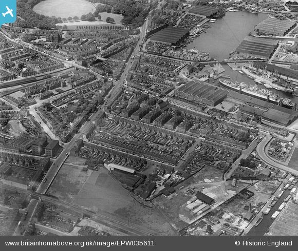
EPW035611 ENGLAND (1931). Lower Road and Sutton Dwellings at Chilton Grove and environs, Rotherhithe, 1931
© Hawlfraint cyfranwyr OpenStreetMap a thrwyddedwyd gan yr OpenStreetMap Foundation. 2025. Trwyddedir y gartograffeg fel CC BY-SA.
Delweddau cyfagos (20)
Manylion
| Pennawd | [EPW035611] Lower Road and Sutton Dwellings at Chilton Grove and environs, Rotherhithe, 1931 |
| Cyfeirnod | EPW035611 |
| Dyddiad | June-1931 |
| Dolen | |
| Enw lle | ROTHERHITHE |
| Plwyf | |
| Ardal | |
| Gwlad | ENGLAND |
| Dwyreiniad / Gogleddiad | 536002, 178769 |
| Hydred / Lledred | -0.04078882000087, 51.491004078284 |
| Cyfeirnod Grid Cenedlaethol | TQ360788 |
Pinnau
 John Wass |
Sunday 20th of September 2020 03:17:29 PM | |
 Stu Giles |
Saturday 15th of December 2018 04:16:16 PM | |
 Stu Giles |
Saturday 15th of December 2018 04:03:38 PM | |
 Stu Giles |
Saturday 15th of December 2018 04:00:01 PM | |
 Stu Giles |
Saturday 15th of December 2018 03:56:45 PM | |
 Stu Giles |
Saturday 15th of December 2018 03:54:03 PM | |
 Stu Giles |
Saturday 15th of December 2018 03:51:40 PM | |
 Stu Giles |
Saturday 15th of December 2018 03:47:40 PM | |
 Mike Floate |
Tuesday 6th of May 2014 04:34:40 PM |


![[EPW035611] Lower Road and Sutton Dwellings at Chilton Grove and environs, Rotherhithe, 1931](http://britainfromabove.org.uk/sites/all/libraries/aerofilms-images/public/100x100/EPW/035/EPW035611.jpg)
![[EPW036266] Sutton Dwellings at Chilton Grove and Lower Road, Rotherhithe, 1931](http://britainfromabove.org.uk/sites/all/libraries/aerofilms-images/public/100x100/EPW/036/EPW036266.jpg)
![[EPW035608] Greenland Dock and Sutton Dwellings at Chilton Grove, Rotherhithe, 1931](http://britainfromabove.org.uk/sites/all/libraries/aerofilms-images/public/100x100/EPW/035/EPW035608.jpg)
![[EPW035609] Lower Road and Sutton Dwellings at Chilton Grove, Rotherhithe, 1931](http://britainfromabove.org.uk/sites/all/libraries/aerofilms-images/public/100x100/EPW/035/EPW035609.jpg)
![[EPW036268] Sutton Dwellings at Chilton Grove and Lower Road, Rotherhithe, 1931](http://britainfromabove.org.uk/sites/all/libraries/aerofilms-images/public/100x100/EPW/036/EPW036268.jpg)
![[EPW035612] Lower Road, Greenland Dock and Sutton Dwellings at Chilton Grove and environs, Rotherhithe, 1931](http://britainfromabove.org.uk/sites/all/libraries/aerofilms-images/public/100x100/EPW/035/EPW035612.jpg)
![[EPW036267] Sutton Dwellings at Chilton Grove and Greenland Dock, Rotherhithe, 1931](http://britainfromabove.org.uk/sites/all/libraries/aerofilms-images/public/100x100/EPW/036/EPW036267.jpg)
![[EPW036264] The Greenland Dock and Sutton Dwellings at Chilton Grove, Rotherhithe, 1931](http://britainfromabove.org.uk/sites/all/libraries/aerofilms-images/public/100x100/EPW/036/EPW036264.jpg)
![[EPW035610] Sutton Dwellings at Chilton Grove and environs, Rotherhithe, 1931](http://britainfromabove.org.uk/sites/all/libraries/aerofilms-images/public/100x100/EPW/035/EPW035610.jpg)
![[EPW036263] Sutton Dwellings at Chilton Grove and Lower Road, Rotherhithe, 1931](http://britainfromabove.org.uk/sites/all/libraries/aerofilms-images/public/100x100/EPW/036/EPW036263.jpg)
![[EPW035613] Lower Road and Sutton Dwellings at Plough Road, Rotherhithe, 1931](http://britainfromabove.org.uk/sites/all/libraries/aerofilms-images/public/100x100/EPW/035/EPW035613.jpg)
![[EAW033237] The Molins Machine Co Works and the surrounding area, Deptford, 1950. This image has been produced from a print marked by Aerofilms Ltd for photo editing.](http://britainfromabove.org.uk/sites/all/libraries/aerofilms-images/public/100x100/EAW/033/EAW033237.jpg)
![[EAW033240] The Molins Machine Co Works, Evelyn Street and the surrounding area, Deptford, 1950](http://britainfromabove.org.uk/sites/all/libraries/aerofilms-images/public/100x100/EAW/033/EAW033240.jpg)
![[EAW033239] The Molins Machine Co Works, Hazelwood House and the surrounding area, Deptford, 1950. This image has been produced from a print marked by Aerofilms Ltd for photo editing.](http://britainfromabove.org.uk/sites/all/libraries/aerofilms-images/public/100x100/EAW/033/EAW033239.jpg)
![[EAW033238] The Molins Machine Co Works and the surrounding area, Deptford, 1950. This image has been produced from a print marked by Aerofilms Ltd for photo editing.](http://britainfromabove.org.uk/sites/all/libraries/aerofilms-images/public/100x100/EAW/033/EAW033238.jpg)
![[EAW033242] The Molins Machine Co Works, Evelyn Street and the surrounding area, Deptford, 1950](http://britainfromabove.org.uk/sites/all/libraries/aerofilms-images/public/100x100/EAW/033/EAW033242.jpg)
![[EAW033184] The Molins Machine Co Works and the surrounding area, Deptford, 1950. This image was marked by Aerofilms Ltd for photo editing.](http://britainfromabove.org.uk/sites/all/libraries/aerofilms-images/public/100x100/EAW/033/EAW033184.jpg)
![[EAW033182] The Molins Machine Co Works and the surrounding area, Deptford, 1950. This image was marked by Aerofilms Ltd for photo editing.](http://britainfromabove.org.uk/sites/all/libraries/aerofilms-images/public/100x100/EAW/033/EAW033182.jpg)
![[EAW033236] The Molins Machine Co Works, Hazelwood House and the surrounding area, Deptford, 1950. This image has been produced from a print marked by Aerofilms Ltd for photo editing.](http://britainfromabove.org.uk/sites/all/libraries/aerofilms-images/public/100x100/EAW/033/EAW033236.jpg)
![[EPW044145] Surrey Commercial Docks, Rotherhithe, from the south-east, 1934](http://britainfromabove.org.uk/sites/all/libraries/aerofilms-images/public/100x100/EPW/044/EPW044145.jpg)
