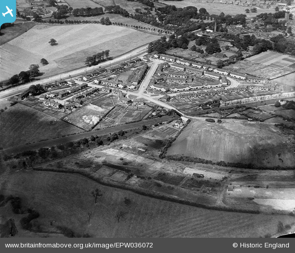
EPW036072 ENGLAND (1931). Sutton Approach and environs, Killingbeck, 1931
© Hawlfraint cyfranwyr OpenStreetMap a thrwyddedwyd gan yr OpenStreetMap Foundation. 2024. Trwyddedir y gartograffeg fel CC BY-SA.
Delweddau cyfagos (11)
Manylion
| Pennawd | [EPW036072] Sutton Approach and environs, Killingbeck, 1931 |
| Cyfeirnod | EPW036072 |
| Dyddiad | 18-July-1931 |
| Dolen | |
| Enw lle | KILLINGBECK |
| Plwyf | |
| Ardal | |
| Gwlad | ENGLAND |
| Dwyreiniad / Gogleddiad | 434490, 434161 |
| Hydred / Lledred | -1.476257447625, 53.802389743201 |
| Cyfeirnod Grid Cenedlaethol | SE345342 |
Pinnau
 Carl |
Saturday 24th of February 2024 04:39:40 PM | |
 trevorsboy |
Friday 1st of November 2019 06:35:52 PM | |
 trevorsboy |
Tuesday 1st of March 2016 07:33:50 PM |


![[EPW036072] Sutton Approach and environs, Killingbeck, 1931](http://britainfromabove.org.uk/sites/all/libraries/aerofilms-images/public/100x100/EPW/036/EPW036072.jpg)
![[EPW036071] Sutton Approach and environs, Killingbeck, 1931](http://britainfromabove.org.uk/sites/all/libraries/aerofilms-images/public/100x100/EPW/036/EPW036071.jpg)
![[EPW036077] Killingbeck Colliery, Sutton Approach and environs, Killingbeck, 1931](http://britainfromabove.org.uk/sites/all/libraries/aerofilms-images/public/100x100/EPW/036/EPW036077.jpg)
![[EPW036075] Killingbeck Colliery, Sutton Approach and environs, Killingbeck, 1931](http://britainfromabove.org.uk/sites/all/libraries/aerofilms-images/public/100x100/EPW/036/EPW036075.jpg)
![[EPW036073] Killingbeck Colliery, Sutton Approach and environs, Killingbeck, 1931](http://britainfromabove.org.uk/sites/all/libraries/aerofilms-images/public/100x100/EPW/036/EPW036073.jpg)
![[EPW036068] Sutton Approach and environs, Killingbeck, 1931](http://britainfromabove.org.uk/sites/all/libraries/aerofilms-images/public/100x100/EPW/036/EPW036068.jpg)
![[EPW036070] Sutton Approach and environs, Killingbeck, 1931](http://britainfromabove.org.uk/sites/all/libraries/aerofilms-images/public/100x100/EPW/036/EPW036070.jpg)
![[EPW036076] Killingbeck Colliery, Sutton Approach and environs, Killingbeck, 1931](http://britainfromabove.org.uk/sites/all/libraries/aerofilms-images/public/100x100/EPW/036/EPW036076.jpg)
![[EPW036067] Sutton Approach and environs, Killingbeck, 1931](http://britainfromabove.org.uk/sites/all/libraries/aerofilms-images/public/100x100/EPW/036/EPW036067.jpg)
![[EPW036074] Killingbeck Colliery, Sutton Approach and environs, Killingbeck, 1931](http://britainfromabove.org.uk/sites/all/libraries/aerofilms-images/public/100x100/EPW/036/EPW036074.jpg)
![[EPW036069] Sutton Approach and environs, Killingbeck, 1931](http://britainfromabove.org.uk/sites/all/libraries/aerofilms-images/public/100x100/EPW/036/EPW036069.jpg)