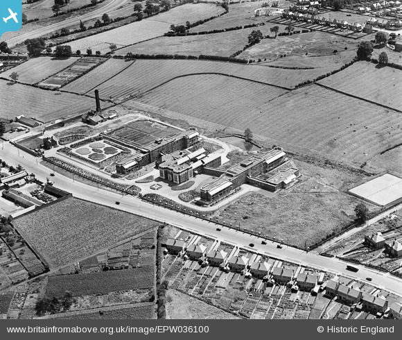
EPW036100 ENGLAND (1931). Derby City General Hospital, Derby, 1931
© Hawlfraint cyfranwyr OpenStreetMap a thrwyddedwyd gan yr OpenStreetMap Foundation. 2025. Trwyddedir y gartograffeg fel CC BY-SA.
Delweddau cyfagos (7)
Manylion
| Pennawd | [EPW036100] Derby City General Hospital, Derby, 1931 |
| Cyfeirnod | EPW036100 |
| Dyddiad | July-1931 |
| Dolen | |
| Enw lle | DERBY |
| Plwyf | |
| Ardal | |
| Gwlad | ENGLAND |
| Dwyreiniad / Gogleddiad | 432681, 334940 |
| Hydred / Lledred | -1.5139812133555, 52.910574442022 |
| Cyfeirnod Grid Cenedlaethol | SK327349 |
Pinnau
 BGP |
Monday 6th of October 2014 09:06:26 PM | |
 BGP |
Monday 6th of October 2014 07:54:36 PM | |
 BGP |
Monday 6th of October 2014 07:44:43 PM | |
 BGP |
Monday 6th of October 2014 07:42:16 PM | |
 BGP |
Monday 6th of October 2014 07:39:29 PM | |
 BGP |
Monday 6th of October 2014 07:35:45 PM | |
 BGP |
Monday 6th of October 2014 07:32:42 PM | |
 BGP |
Monday 6th of October 2014 07:25:08 PM | |
 BGP |
Monday 6th of October 2014 07:23:21 PM |


![[EPW036100] Derby City General Hospital, Derby, 1931](http://britainfromabove.org.uk/sites/all/libraries/aerofilms-images/public/100x100/EPW/036/EPW036100.jpg)
![[EPW036101] Derby City General Hospital and environs, Derby, 1931](http://britainfromabove.org.uk/sites/all/libraries/aerofilms-images/public/100x100/EPW/036/EPW036101.jpg)
![[EPW036102] Derby City General Hospital and environs, Derby, 1931](http://britainfromabove.org.uk/sites/all/libraries/aerofilms-images/public/100x100/EPW/036/EPW036102.jpg)
![[EPW036097] Derby City General Hospital and environs, Derby, 1931](http://britainfromabove.org.uk/sites/all/libraries/aerofilms-images/public/100x100/EPW/036/EPW036097.jpg)
![[EPW036103] Derby City General Hospital and environs, Derby, 1931](http://britainfromabove.org.uk/sites/all/libraries/aerofilms-images/public/100x100/EPW/036/EPW036103.jpg)
![[EPW036098] Derby City General Hospital and environs, Derby, 1931](http://britainfromabove.org.uk/sites/all/libraries/aerofilms-images/public/100x100/EPW/036/EPW036098.jpg)
![[EPW036099] Derby City General Hospital and environs, Derby, 1931](http://britainfromabove.org.uk/sites/all/libraries/aerofilms-images/public/100x100/EPW/036/EPW036099.jpg)