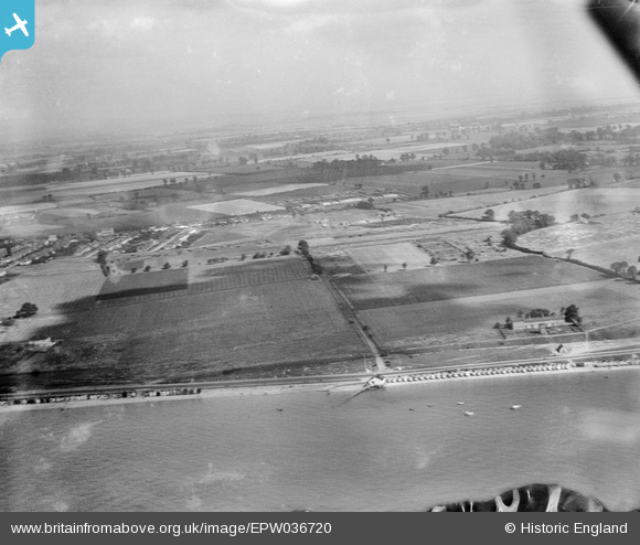
EPW036720 ENGLAND (1931). Fields to the east of Thorpe Bay, Southend-on-Sea, from the south-west, 1931
© Hawlfraint cyfranwyr OpenStreetMap a thrwyddedwyd gan yr OpenStreetMap Foundation. 2025. Trwyddedir y gartograffeg fel CC BY-SA.
Delweddau cyfagos (5)
Manylion
| Pennawd | [EPW036720] Fields to the east of Thorpe Bay, Southend-on-Sea, from the south-west, 1931 |
| Cyfeirnod | EPW036720 |
| Dyddiad | September-1931 |
| Dolen | |
| Enw lle | SOUTHEND-ON-SEA |
| Plwyf | |
| Ardal | |
| Gwlad | ENGLAND |
| Dwyreiniad / Gogleddiad | 591868, 184526 |
| Hydred / Lledred | 0.76627416839338, 51.526519315254 |
| Cyfeirnod Grid Cenedlaethol | TQ919845 |
Pinnau
 bargee1937 |
Wednesday 16th of September 2015 01:15:22 PM |


![[EPW036720] Fields to the east of Thorpe Bay, Southend-on-Sea, from the south-west, 1931](http://britainfromabove.org.uk/sites/all/libraries/aerofilms-images/public/100x100/EPW/036/EPW036720.jpg)
![[EPW036743] Beach huts along Thorpe Esplanade and surrounding countryside, Thorpe Bay, 1931](http://britainfromabove.org.uk/sites/all/libraries/aerofilms-images/public/100x100/EPW/036/EPW036743.jpg)
![[EPW036718] Beach huts at South Shoebury Common, the Coastguard Station and surrounding countryside, Southend-on-Sea, 1931](http://britainfromabove.org.uk/sites/all/libraries/aerofilms-images/public/100x100/EPW/036/EPW036718.jpg)
![[EPW040963] Thorpe Esplanade and Thorpe Bay, Southend-on-Sea, from the south-east, 1933](http://britainfromabove.org.uk/sites/all/libraries/aerofilms-images/public/100x100/EPW/040/EPW040963.jpg)
![[EPW036699] A detached house alongside Thorpe Bay Esplanade and the seafront, Thorpe Bay, 1931](http://britainfromabove.org.uk/sites/all/libraries/aerofilms-images/public/100x100/EPW/036/EPW036699.jpg)