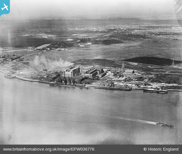
EPW036776 ENGLAND (1931). The Creekmouth Power Station and the River Thames, Creekmouth, from the south-east, 1931
© Hawlfraint cyfranwyr OpenStreetMap a thrwyddedwyd gan yr OpenStreetMap Foundation. 2025. Trwyddedir y gartograffeg fel CC BY-SA.
Delweddau cyfagos (7)
Manylion
| Pennawd | [EPW036776] The Creekmouth Power Station and the River Thames, Creekmouth, from the south-east, 1931 |
| Cyfeirnod | EPW036776 |
| Dyddiad | September-1931 |
| Dolen | |
| Enw lle | CREEKMOUTH |
| Plwyf | |
| Ardal | |
| Gwlad | ENGLAND |
| Dwyreiniad / Gogleddiad | 546694, 181493 |
| Hydred / Lledred | 0.11426181370615, 51.512809832924 |
| Cyfeirnod Grid Cenedlaethol | TQ467815 |
Pinnau
 stack1378 |
Thursday 17th of January 2019 11:05:35 PM | |
 rac |
Thursday 13th of September 2018 09:05:39 PM | |
 rac |
Thursday 13th of September 2018 09:04:43 PM | |
 rac |
Thursday 13th of September 2018 09:03:43 PM | |
 rac |
Thursday 13th of September 2018 09:01:50 PM | |
 rac |
Thursday 13th of September 2018 09:00:56 PM | |
 rac |
Thursday 13th of September 2018 09:00:14 PM | |
 rac |
Thursday 13th of September 2018 08:59:19 PM |


![[EPW036776] The Creekmouth Power Station and the River Thames, Creekmouth, from the south-east, 1931](http://britainfromabove.org.uk/sites/all/libraries/aerofilms-images/public/100x100/EPW/036/EPW036776.jpg)
![[EPW010662] Barking Power Station, Creekmouth, 1924](http://britainfromabove.org.uk/sites/all/libraries/aerofilms-images/public/100x100/EPW/010/EPW010662.jpg)
![[EPW010668] Barking Power Station, Creekmouth, 1924](http://britainfromabove.org.uk/sites/all/libraries/aerofilms-images/public/100x100/EPW/010/EPW010668.jpg)
![[EPW010665] Barking Power Station, Creekmouth, 1924](http://britainfromabove.org.uk/sites/all/libraries/aerofilms-images/public/100x100/EPW/010/EPW010665.jpg)
![[EPW008727] Barking Power Station under construction, Creekmouth, 1923](http://britainfromabove.org.uk/sites/all/libraries/aerofilms-images/public/100x100/EPW/008/EPW008727.jpg)
![[EPW009686] Barking Power Station under construction, Creekmouth, 1923](http://britainfromabove.org.uk/sites/all/libraries/aerofilms-images/public/100x100/EPW/009/EPW009686.jpg)
![[EPW010661] Barking Power Station, Creekmouth, 1924](http://britainfromabove.org.uk/sites/all/libraries/aerofilms-images/public/100x100/EPW/010/EPW010661.jpg)