
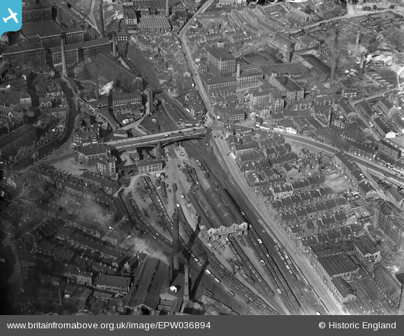
EPW036894 ENGLAND (1931). North Bridge, North Bridge Station and environs, Halifax, 1931
© Hawlfraint cyfranwyr OpenStreetMap a thrwyddedwyd gan yr OpenStreetMap Foundation. 2025. Trwyddedir y gartograffeg fel CC BY-SA.
Delweddau cyfagos (8)
EPW036894

EPW036893

EPW036892

EPW057281

EAW015954

EAW009201

EAW015958

EAW028061

Manylion
| Pennawd | [EPW036894] North Bridge, North Bridge Station and environs, Halifax, 1931 |
| Cyfeirnod | EPW036894 |
| Dyddiad | September-1931 |
| Dolen | |
| Enw lle | HALIFAX |
| Plwyf | |
| Ardal | |
| Gwlad | ENGLAND |
| Dwyreiniad / Gogleddiad | 409428, 425686 |
| Hydred / Lledred | -1.857088445741, 53.727265742894 |
| Cyfeirnod Grid Cenedlaethol | SE094257 |
Pinnau
 |
 Pablo |
Friday 18th of October 2024 08:53:42 PM |
HOLMES |
Wednesday 23rd of September 2015 12:13:07 PM | |
AC |
Sunday 21st of July 2013 08:55:14 AM | |
AC |
Sunday 21st of July 2013 08:52:02 AM | |
AC |
Sunday 21st of July 2013 08:51:22 AM | |
David |
Monday 21st of January 2013 01:49:08 PM |