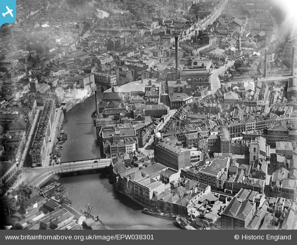
EPW038301 ENGLAND (1932). Industry around the Bristol Bridge, Bristol, 1932
© Hawlfraint cyfranwyr OpenStreetMap a thrwyddedwyd gan yr OpenStreetMap Foundation. 2025. Trwyddedir y gartograffeg fel CC BY-SA.
Delweddau cyfagos (26)
Manylion
| Pennawd | [EPW038301] Industry around the Bristol Bridge, Bristol, 1932 |
| Cyfeirnod | EPW038301 |
| Dyddiad | June-1932 |
| Dolen | |
| Enw lle | BRISTOL |
| Plwyf | |
| Ardal | |
| Gwlad | ENGLAND |
| Dwyreiniad / Gogleddiad | 359162, 172921 |
| Hydred / Lledred | -2.5877941289205, 51.45330759108 |
| Cyfeirnod Grid Cenedlaethol | ST592729 |
Pinnau
 MB |
Monday 29th of August 2016 10:20:07 PM | |
 MB |
Monday 29th of August 2016 10:19:05 PM | |
 MB |
Monday 29th of August 2016 10:17:48 PM | |
 Class31 |
Saturday 14th of June 2014 09:42:24 PM | |
 Class31 |
Monday 10th of June 2013 09:02:25 PM |


![[EPW038301] Industry around the Bristol Bridge, Bristol, 1932](http://britainfromabove.org.uk/sites/all/libraries/aerofilms-images/public/100x100/EPW/038/EPW038301.jpg)
![[EPW038302] Industry around the Bristol Bridge, Bristol, 1932](http://britainfromabove.org.uk/sites/all/libraries/aerofilms-images/public/100x100/EPW/038/EPW038302.jpg)
![[EPW034455] Victoria Street and Works off Bath Street, Bristol, 1930](http://britainfromabove.org.uk/sites/all/libraries/aerofilms-images/public/100x100/EPW/034/EPW034455.jpg)
![[EPW034460] Bennett's Counterslip Works (Printing and Stationery) and the Tramway Generating Station, Bristol, 1930](http://britainfromabove.org.uk/sites/all/libraries/aerofilms-images/public/100x100/EPW/034/EPW034460.jpg)
![[EPW034452] George's Brewey, the Tramway Generating Station and Victoria Street, Bristol, 1930](http://britainfromabove.org.uk/sites/all/libraries/aerofilms-images/public/100x100/EPW/034/EPW034452.jpg)
![[EPW034459] Bennett's Counterslip Works (Printing and Stationery) and the Tramway Generating Station, Bristol, 1930](http://britainfromabove.org.uk/sites/all/libraries/aerofilms-images/public/100x100/EPW/034/EPW034459.jpg)
![[EPW034458] Victoria Street and Temple Street and environs, Bristol, 1930](http://britainfromabove.org.uk/sites/all/libraries/aerofilms-images/public/100x100/EPW/034/EPW034458.jpg)
![[EPW034454] George's Brewery, Bennett's Counterslip Works (Print and Stationey) and the Tramway Generating Station, Bristol, 1930](http://britainfromabove.org.uk/sites/all/libraries/aerofilms-images/public/100x100/EPW/034/EPW034454.jpg)
![[EPW034453] George's Brewey, the Tramway Generating Station and Temple Street, Bristol, 1930](http://britainfromabove.org.uk/sites/all/libraries/aerofilms-images/public/100x100/EPW/034/EPW034453.jpg)
![[EPW038304] Victoria Street, George's Brewey and the W.B. Harris Print Works, Bristol, 1932](http://britainfromabove.org.uk/sites/all/libraries/aerofilms-images/public/100x100/EPW/038/EPW038304.jpg)
![[EPW038300] George's Brewery and Bristol Bridge, Bristol, 1932](http://britainfromabove.org.uk/sites/all/libraries/aerofilms-images/public/100x100/EPW/038/EPW038300.jpg)
![[EPW034451] Tramway Generating Station at Philip Street and the area around St Philip's Bridge and Bristol Bridge, Bristol, 1930](http://britainfromabove.org.uk/sites/all/libraries/aerofilms-images/public/100x100/EPW/034/EPW034451.jpg)
![[EPW038303] Industry around the Bristol Bridge, Bristol, 1932](http://britainfromabove.org.uk/sites/all/libraries/aerofilms-images/public/100x100/EPW/038/EPW038303.jpg)
![[EPW034457] St Philip's Bridge, Works off Bath Street and environs, Bristol, 1930](http://britainfromabove.org.uk/sites/all/libraries/aerofilms-images/public/100x100/EPW/034/EPW034457.jpg)
![[EAW032256] Bath Street, Victoria Street and Redcliff Street, Bristol, 1950. This image was marked by Aerofilms Ltd for photo editing.](http://britainfromabove.org.uk/sites/all/libraries/aerofilms-images/public/100x100/EAW/032/EAW032256.jpg)
![[EAW032257] Victoria Street, Redcliff Street and environs, Bristol, 1950. This image was marked by Aerofilms Ltd for photo editing.](http://britainfromabove.org.uk/sites/all/libraries/aerofilms-images/public/100x100/EAW/032/EAW032257.jpg)
![[EAW032259] Victoria Street, the E. S. & A. Robinson Premises on Redcliff Street and environs, 1950. This image was marked by Aerofilms Ltd for photo editing.](http://britainfromabove.org.uk/sites/all/libraries/aerofilms-images/public/100x100/EAW/032/EAW032259.jpg)
![[EPW034450] Tramway Generating Station at Philip Street and the area around St Philip's Bridge and Bristol Bridge, Bristol, 1930](http://britainfromabove.org.uk/sites/all/libraries/aerofilms-images/public/100x100/EPW/034/EPW034450.jpg)
![[EPW033498] Bristol Bridge and the city, Bristol, 1930](http://britainfromabove.org.uk/sites/all/libraries/aerofilms-images/public/100x100/EPW/033/EPW033498.jpg)
![[EAW032254] Victoria Street, the E. S. & A. Robinson Premises on Redcliff Street and environs, 1950. This image was marked by Aerofilms Ltd for photo editing.](http://britainfromabove.org.uk/sites/all/libraries/aerofilms-images/public/100x100/EAW/032/EAW032254.jpg)
![[EAW032258] Victoria Street, the E. S. & A. Robinson Premises on Redcliff Street and environs, 1950. This image was marked by Aerofilms Ltd for photo editing.](http://britainfromabove.org.uk/sites/all/libraries/aerofilms-images/public/100x100/EAW/032/EAW032258.jpg)
![[EPW060117] The city centre, Bristol, 1938](http://britainfromabove.org.uk/sites/all/libraries/aerofilms-images/public/100x100/EPW/060/EPW060117.jpg)
![[EPW034456] Tramway Generating Station at Philip Street and the area around St Philip's Bridge and Bristol Bridge, Bristol, 1930](http://britainfromabove.org.uk/sites/all/libraries/aerofilms-images/public/100x100/EPW/034/EPW034456.jpg)
![[EAW032255] Victoria Street, Redcliff Street and Bristol Bridge, Bristol, 1950. This image was marked by Aerofilms Ltd for photo editing.](http://britainfromabove.org.uk/sites/all/libraries/aerofilms-images/public/100x100/EAW/032/EAW032255.jpg)
![[EAW032260] Victoria Street, Redcliff Street and Bristol Bridge, Bristol, 1950. This image was marked by Aerofilms Ltd for photo editing.](http://britainfromabove.org.uk/sites/all/libraries/aerofilms-images/public/100x100/EAW/032/EAW032260.jpg)
![[EAW032261] Redcliff Street, the Church of St Thomas the Martyr and environs, Bristol, 1950. This image was marked by Aerofilms Ltd for photo editing.](http://britainfromabove.org.uk/sites/all/libraries/aerofilms-images/public/100x100/EAW/032/EAW032261.jpg)
