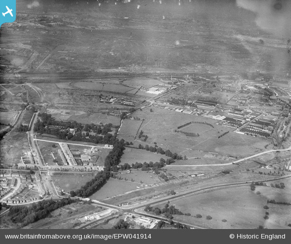
EPW041914 ENGLAND (1933). The Horse Ring football ground and various factories, Park Royal, from the south-west, 1933
© Hawlfraint cyfranwyr OpenStreetMap a thrwyddedwyd gan yr OpenStreetMap Foundation. 2025. Trwyddedir y gartograffeg fel CC BY-SA.
Delweddau cyfagos (6)
Manylion
| Pennawd | [EPW041914] The Horse Ring football ground and various factories, Park Royal, from the south-west, 1933 |
| Cyfeirnod | EPW041914 |
| Dyddiad | June-1933 |
| Dolen | |
| Enw lle | PARK ROYAL |
| Plwyf | |
| Ardal | |
| Gwlad | ENGLAND |
| Dwyreiniad / Gogleddiad | 518881, 182749 |
| Hydred / Lledred | -0.28596024036562, 51.530638078921 |
| Cyfeirnod Grid Cenedlaethol | TQ189827 |
Pinnau
 Leslie B |
Tuesday 18th of December 2018 04:04:17 PM | |
 The Laird |
Thursday 12th of January 2017 06:40:07 PM | |
 The Laird |
Thursday 12th of January 2017 06:38:43 PM | |
 Class31 |
Wednesday 19th of August 2015 09:09:48 AM | |
 colsouth111 |
Friday 21st of June 2013 05:12:46 PM | |
It's Twyford Abbey to me too. |
 Class31 |
Wednesday 19th of August 2015 09:11:21 AM |


![[EPW041914] The Horse Ring football ground and various factories, Park Royal, from the south-west, 1933](http://britainfromabove.org.uk/sites/all/libraries/aerofilms-images/public/100x100/EPW/041/EPW041914.jpg)
![[EPW041911] The Horse Ring football ground and various factories, Park Royal, from the south-west, 1933](http://britainfromabove.org.uk/sites/all/libraries/aerofilms-images/public/100x100/EPW/041/EPW041911.jpg)
![[EPW041912] The Horse Ring football ground and various factories, Park Royal, from the south-west, 1933](http://britainfromabove.org.uk/sites/all/libraries/aerofilms-images/public/100x100/EPW/041/EPW041912.jpg)
![[EPW041913] The Horse Ring football ground and various factories, Park Royal, from the south-west, 1933](http://britainfromabove.org.uk/sites/all/libraries/aerofilms-images/public/100x100/EPW/041/EPW041913.jpg)
![[EPW041910] The Horse Ring football ground and various factories, Park Royal, from the south-west, 1933](http://britainfromabove.org.uk/sites/all/libraries/aerofilms-images/public/100x100/EPW/041/EPW041910.jpg)
![[EPW041848] The Horse Ring football ground, Park Royal, from the south-west, 1933. This image has been produced from a damaged negative.](http://britainfromabove.org.uk/sites/all/libraries/aerofilms-images/public/100x100/EPW/041/EPW041848.jpg)