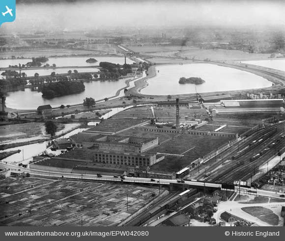
EPW042080 ENGLAND (1933). The Harris Lebus Cabinet Works and environs, Tottenham Hale, from the north-west, 1933
© Hawlfraint cyfranwyr OpenStreetMap a thrwyddedwyd gan yr OpenStreetMap Foundation. 2025. Trwyddedir y gartograffeg fel CC BY-SA.
Delweddau cyfagos (23)
Manylion
| Pennawd | [EPW042080] The Harris Lebus Cabinet Works and environs, Tottenham Hale, from the north-west, 1933 |
| Cyfeirnod | EPW042080 |
| Dyddiad | June-1933 |
| Dolen | |
| Enw lle | TOTTENHAM HALE |
| Plwyf | |
| Ardal | |
| Gwlad | ENGLAND |
| Dwyreiniad / Gogleddiad | 534584, 189388 |
| Hydred / Lledred | -0.057142665824014, 51.586779395043 |
| Cyfeirnod Grid Cenedlaethol | TQ346894 |
Pinnau
 Leslie B |
Thursday 24th of March 2022 09:20:19 PM | |
 Dank |
Thursday 22nd of April 2021 03:43:16 PM | |
 Dank |
Thursday 22nd of April 2021 03:42:03 PM | |
 Dank |
Thursday 22nd of April 2021 03:40:37 PM | |
 Dank |
Thursday 22nd of April 2021 03:40:07 PM | |
 Dank |
Thursday 22nd of April 2021 03:39:01 PM |


![[EPW042080] The Harris Lebus Cabinet Works and environs, Tottenham Hale, from the north-west, 1933](http://britainfromabove.org.uk/sites/all/libraries/aerofilms-images/public/100x100/EPW/042/EPW042080.jpg)
![[EPW006778] Harris Lebus Cabinet Works, Tottenham Hale, 1921](http://britainfromabove.org.uk/sites/all/libraries/aerofilms-images/public/100x100/EPW/006/EPW006778.jpg)
![[EPW055752] The Harris Lebus Cabinet Works, Tottenham Hale, 1937](http://britainfromabove.org.uk/sites/all/libraries/aerofilms-images/public/100x100/EPW/055/EPW055752.jpg)
![[EPW056626] Harris Lebus Cabinet Works, Tottenham Hale, 1938](http://britainfromabove.org.uk/sites/all/libraries/aerofilms-images/public/100x100/EPW/056/EPW056626.jpg)
![[EPW055754] The Harris Lebus Cabinet Works, Tottenham Hale, 1937](http://britainfromabove.org.uk/sites/all/libraries/aerofilms-images/public/100x100/EPW/055/EPW055754.jpg)
![[EPW056629] Harris Lebus Cabinet Works, Tottenham Hale, 1938](http://britainfromabove.org.uk/sites/all/libraries/aerofilms-images/public/100x100/EPW/056/EPW056629.jpg)
![[EPW056625] Harris Lebus Cabinet Works, Tottenham Hale, from the north-east, 1938](http://britainfromabove.org.uk/sites/all/libraries/aerofilms-images/public/100x100/EPW/056/EPW056625.jpg)
![[EPW056628] Harris Lebus Cabinet Works, Tottenham Hale, from the north-east, 1938](http://britainfromabove.org.uk/sites/all/libraries/aerofilms-images/public/100x100/EPW/056/EPW056628.jpg)
![[EPW042079] The Harris Lebus Cabinet Works, Tottenham Hale, 1933](http://britainfromabove.org.uk/sites/all/libraries/aerofilms-images/public/100x100/EPW/042/EPW042079.jpg)
![[EPW055753] The Harris Lebus Cabinet Works, Tottenham Hale, 1937. This image has been produced from a damaged negative.](http://britainfromabove.org.uk/sites/all/libraries/aerofilms-images/public/100x100/EPW/055/EPW055753.jpg)
![[EPW056627] Harris Lebus Cabinet Works, Tottenham Hale, from the north-east, 1938](http://britainfromabove.org.uk/sites/all/libraries/aerofilms-images/public/100x100/EPW/056/EPW056627.jpg)
![[EAW034771] The Gestetner Duplicating Machine Works off Broad Lane, Tottenham Hale, 1951. This image was marked by Aerofilms Ltd for photo editing.](http://britainfromabove.org.uk/sites/all/libraries/aerofilms-images/public/100x100/EAW/034/EAW034771.jpg)
![[EAW034776] The Gestetner Duplicating Machine Works off Broad Lane, Tottenham Hale, 1951](http://britainfromabove.org.uk/sites/all/libraries/aerofilms-images/public/100x100/EAW/034/EAW034776.jpg)
![[EAW034775] The Gestetner Duplicating Machine Works off Broad Lane, Tottenham Hale, 1951. This image was marked by Aerofilms Ltd for photo editing.](http://britainfromabove.org.uk/sites/all/libraries/aerofilms-images/public/100x100/EAW/034/EAW034775.jpg)
![[EPW009964] Factories on Broad Lane and Fawley Road, Tottenham Hale, 1924](http://britainfromabove.org.uk/sites/all/libraries/aerofilms-images/public/100x100/EPW/009/EPW009964.jpg)
![[EPW055750] The Harris Lebus Cabinet Works, Tottenham Hale, 1937. This image has been produced from a damaged negative.](http://britainfromabove.org.uk/sites/all/libraries/aerofilms-images/public/100x100/EPW/055/EPW055750.jpg)
![[EAW034777] The Gestetner Duplicating Machine Works off Broad Lane, Tottenham Hale, 1951. This image was marked by Aerofilms Ltd for photo editing.](http://britainfromabove.org.uk/sites/all/libraries/aerofilms-images/public/100x100/EAW/034/EAW034777.jpg)
![[EAW034770] The Gestetner Duplicating Machine Works off Broad Lane, Tottenham Hale, 1951](http://britainfromabove.org.uk/sites/all/libraries/aerofilms-images/public/100x100/EAW/034/EAW034770.jpg)
![[EPW056644] The Tottenham Wharf and Storage Co Ltd premises on Ferry Lane, Tottenham Hale, 1938](http://britainfromabove.org.uk/sites/all/libraries/aerofilms-images/public/100x100/EPW/056/EPW056644.jpg)
![[EPW056641] The Tottenham Wharf and Storage Co Ltd premises on Ferry Lane, Tottenham Hale, 1938](http://britainfromabove.org.uk/sites/all/libraries/aerofilms-images/public/100x100/EPW/056/EPW056641.jpg)
![[EPW009963] Factories on Broad Lane and Fawley Road, Tottenham Hale, 1924](http://britainfromabove.org.uk/sites/all/libraries/aerofilms-images/public/100x100/EPW/009/EPW009963.jpg)
![[EPW056640] The Tottenham Wharf and Storage Co Ltd premises on Ferry Lane, Tottenham Hale, 1938](http://britainfromabove.org.uk/sites/all/libraries/aerofilms-images/public/100x100/EPW/056/EPW056640.jpg)
![[EPW042010] Factories along Ashley Road, Tottenham Hale, 1933](http://britainfromabove.org.uk/sites/all/libraries/aerofilms-images/public/100x100/EPW/042/EPW042010.jpg)