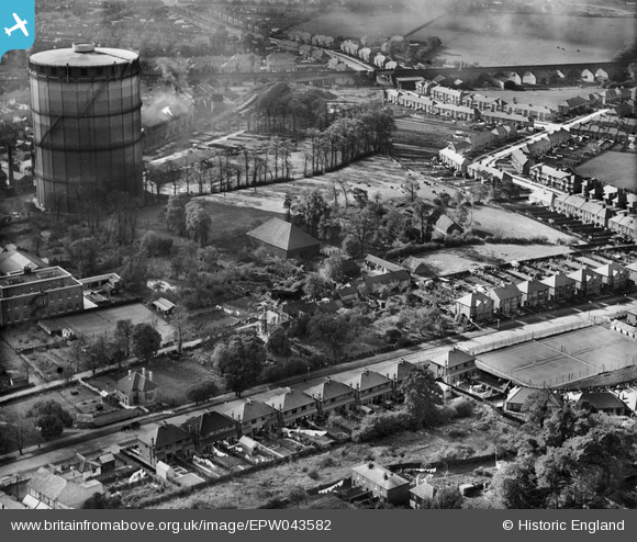
EPW043582 ENGLAND (1933). The Grange alongside the Gas Works, Roxeth, 1933
© Hawlfraint cyfranwyr OpenStreetMap a thrwyddedwyd gan yr OpenStreetMap Foundation. 2025. Trwyddedir y gartograffeg fel CC BY-SA.
Delweddau cyfagos (7)
Manylion
| Pennawd | [EPW043582] The Grange alongside the Gas Works, Roxeth, 1933 |
| Cyfeirnod | EPW043582 |
| Dyddiad | October-1933 |
| Dolen | |
| Enw lle | ROXETH |
| Plwyf | |
| Ardal | |
| Gwlad | ENGLAND |
| Dwyreiniad / Gogleddiad | 514413, 186878 |
| Hydred / Lledred | -0.34900783392979, 51.568675667022 |
| Cyfeirnod Grid Cenedlaethol | TQ144869 |
Pinnau
 The Laird |
Tuesday 15th of September 2015 08:59:45 PM | |
 The Laird |
Wednesday 25th of June 2014 07:12:49 PM | |
 JamesMac |
Tuesday 22nd of October 2013 06:28:39 PM | |
 JamesMac |
Tuesday 22nd of October 2013 06:27:00 PM | |
 JamesMac |
Tuesday 22nd of October 2013 06:25:06 PM | |
 JamesMac |
Tuesday 22nd of October 2013 06:23:43 PM | |
 JamesMac |
Tuesday 22nd of October 2013 06:21:32 PM | |
 JamesMac |
Tuesday 22nd of October 2013 06:20:57 PM | |
 The Laird |
Tuesday 17th of September 2013 03:34:18 PM |


![[EPW043582] The Grange alongside the Gas Works, Roxeth, 1933](http://britainfromabove.org.uk/sites/all/libraries/aerofilms-images/public/100x100/EPW/043/EPW043582.jpg)
![[EPW043580] The Grange, Roxeth, 1933](http://britainfromabove.org.uk/sites/all/libraries/aerofilms-images/public/100x100/EPW/043/EPW043580.jpg)
![[EPW043585] The Grange alongside the Gas Works, Roxeth, 1933](http://britainfromabove.org.uk/sites/all/libraries/aerofilms-images/public/100x100/EPW/043/EPW043585.jpg)
![[EPW043581] The Grange alongside the Gas Works, Roxeth, 1933](http://britainfromabove.org.uk/sites/all/libraries/aerofilms-images/public/100x100/EPW/043/EPW043581.jpg)
![[EPW043584] The Grange and the Telephone Exchange alongside the Gas Works, Roxeth, 1933](http://britainfromabove.org.uk/sites/all/libraries/aerofilms-images/public/100x100/EPW/043/EPW043584.jpg)
![[EPW043583] The Grange alongside Dudley Road and the Gas Works, Roxeth, 1933](http://britainfromabove.org.uk/sites/all/libraries/aerofilms-images/public/100x100/EPW/043/EPW043583.jpg)
![[EPW009579] The Gas Works on Northolt Road and environs, Roxeth, 1923. This image has been produced from a damaged negative.](http://britainfromabove.org.uk/sites/all/libraries/aerofilms-images/public/100x100/EPW/009/EPW009579.jpg)