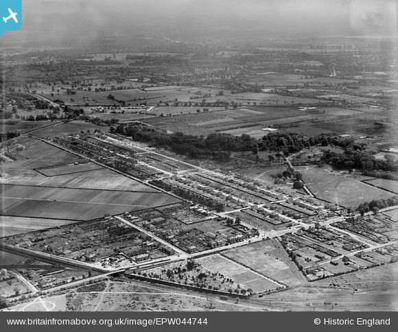
EPW044744 ENGLAND (1934). Hanworth Road, Powder Mill Lane and environs, Twickenham, from the north, 1934
© Hawlfraint cyfranwyr OpenStreetMap a thrwyddedwyd gan yr OpenStreetMap Foundation. 2025. Trwyddedir y gartograffeg fel CC BY-SA.
Delweddau cyfagos (7)
Manylion
| Pennawd | [EPW044744] Hanworth Road, Powder Mill Lane and environs, Twickenham, from the north, 1934 |
| Cyfeirnod | EPW044744 |
| Dyddiad | June-1934 |
| Dolen | |
| Enw lle | TWICKENHAM |
| Plwyf | |
| Ardal | |
| Gwlad | ENGLAND |
| Dwyreiniad / Gogleddiad | 512886, 173462 |
| Hydred / Lledred | -0.37532895321539, 51.448388890739 |
| Cyfeirnod Grid Cenedlaethol | TQ129735 |
Pinnau
 Brian |
Monday 9th of February 2015 05:56:26 PM | |
 Brian |
Monday 9th of February 2015 05:54:09 PM | |
 Stuart |
Monday 22nd of September 2014 05:03:01 PM | |
 Stuart |
Monday 22nd of September 2014 04:57:16 PM | |
 MB |
Friday 6th of December 2013 12:13:19 AM | |
 MB |
Friday 6th of December 2013 12:07:58 AM | |
 Andrew |
Thursday 5th of December 2013 11:21:46 PM |


![[EPW044744] Hanworth Road, Powder Mill Lane and environs, Twickenham, from the north, 1934](http://britainfromabove.org.uk/sites/all/libraries/aerofilms-images/public/100x100/EPW/044/EPW044744.jpg)
![[EPW044335] Waverley Avenue, Lyndhurst Avenue and environs, Twickenham, 1934](http://britainfromabove.org.uk/sites/all/libraries/aerofilms-images/public/100x100/EPW/044/EPW044335.jpg)
![[EPW044332] Waverley Avenue, Lyndhurst Avenue and environs, Twickenham, 1934](http://britainfromabove.org.uk/sites/all/libraries/aerofilms-images/public/100x100/EPW/044/EPW044332.jpg)
![[EPW044746] Powder Mill Lane and housing under construction along Waverley Avenue and Lyndhurst Avenue, Twickenham, from the north-west, 1934](http://britainfromabove.org.uk/sites/all/libraries/aerofilms-images/public/100x100/EPW/044/EPW044746.jpg)
![[EPW044334] Waverley Avenue, Lyndhurst Avenue and environs, Twickenham, 1934](http://britainfromabove.org.uk/sites/all/libraries/aerofilms-images/public/100x100/EPW/044/EPW044334.jpg)
![[EPW044337] Waverley Avenue, Lyndhurst Avenue and environs, Twickenham, 1934](http://britainfromabove.org.uk/sites/all/libraries/aerofilms-images/public/100x100/EPW/044/EPW044337.jpg)
![[EPW044336] Waverley Avenue, Lyndhurst Avenue and environs, Twickenham, 1934](http://britainfromabove.org.uk/sites/all/libraries/aerofilms-images/public/100x100/EPW/044/EPW044336.jpg)