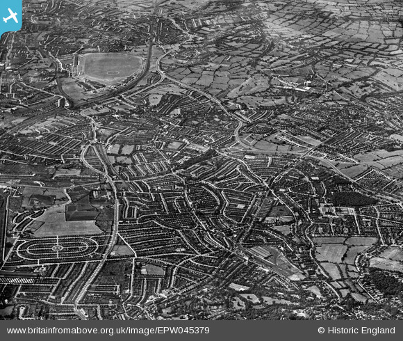
EPW045379 ENGLAND (1934). The view from Child's Hill towards Edgware including RAF Hendon airfield, Hendon, from the south-east, 1934
© Hawlfraint cyfranwyr OpenStreetMap a thrwyddedwyd gan yr OpenStreetMap Foundation. 2025. Trwyddedir y gartograffeg fel CC BY-SA.
Delweddau cyfagos (14)
Manylion
| Pennawd | [EPW045379] The view from Child's Hill towards Edgware including RAF Hendon airfield, Hendon, from the south-east, 1934 |
| Cyfeirnod | EPW045379 |
| Dyddiad | July-1934 |
| Dolen | |
| Enw lle | HENDON |
| Plwyf | |
| Ardal | |
| Gwlad | ENGLAND |
| Dwyreiniad / Gogleddiad | 525032, 187353 |
| Hydred / Lledred | -0.19568374751501, 51.570689877809 |
| Cyfeirnod Grid Cenedlaethol | TQ250874 |
Pinnau
 Vectensian |
Sunday 14th of June 2020 12:27:38 PM |


![[EPW045379] The view from Child's Hill towards Edgware including RAF Hendon airfield, Hendon, from the south-east, 1934](http://britainfromabove.org.uk/sites/all/libraries/aerofilms-images/public/100x100/EPW/045/EPW045379.jpg)
![[EPW021172] Golders Green Station and environs, Golders Green, 1928. This image has been produced from a print.](http://britainfromabove.org.uk/sites/all/libraries/aerofilms-images/public/100x100/EPW/021/EPW021172.jpg)
![[EPW005990] Hodford Road, Rodborough Road and Golders Green Station, Golders Green, 1921. This image has been produced from a print affected by flare.](http://britainfromabove.org.uk/sites/all/libraries/aerofilms-images/public/100x100/EPW/005/EPW005990.jpg)
![[EPW028182] The Ridgeway, Woodstock Road and surrounding residential area, Golders Green, 1929](http://britainfromabove.org.uk/sites/all/libraries/aerofilms-images/public/100x100/EPW/028/EPW028182.jpg)
![[EPW028190] Golders Green railway station, Finchley Road and environs, Golders Green, 1929](http://britainfromabove.org.uk/sites/all/libraries/aerofilms-images/public/100x100/EPW/028/EPW028190.jpg)
![[EPW000810] Golders Green Station, Golders Green, 1920](http://britainfromabove.org.uk/sites/all/libraries/aerofilms-images/public/100x100/EPW/000/EPW000810.jpg)
![[EPW008218] The Underground Electric Railways Company of London Ltd (UERL) extension from Golders Green to Hendon and Edgware under construction, Child's Hill, 1922. This image has been produced from a copy-negative.](http://britainfromabove.org.uk/sites/all/libraries/aerofilms-images/public/100x100/EPW/008/EPW008218.jpg)
![[EPW008214] Golders Green Road, the Railway Works at Golders Green railway station and environs, Childs Hill, 1922. This image has been produced from a print.](http://britainfromabove.org.uk/sites/all/libraries/aerofilms-images/public/100x100/EPW/008/EPW008214.jpg)
![[EPW009094] The Station, Railway Works and environs, Golders Green, 1923](http://britainfromabove.org.uk/sites/all/libraries/aerofilms-images/public/100x100/EPW/009/EPW009094.jpg)
![[EPW009095] Golders Green Road and environs, Golders Green, 1923](http://britainfromabove.org.uk/sites/all/libraries/aerofilms-images/public/100x100/EPW/009/EPW009095.jpg)
![[EPW009535] Golders Green Station and environs, Golders Green, 1923. This image has been produced from a print.](http://britainfromabove.org.uk/sites/all/libraries/aerofilms-images/public/100x100/EPW/009/EPW009535.jpg)
![[EPW024243] Golders Green underground station and environs, Golders Green, 1928](http://britainfromabove.org.uk/sites/all/libraries/aerofilms-images/public/100x100/EPW/024/EPW024243.jpg)
![[EPW047879] The London Passenger Transport Board Railway Works and the view to Hampstead Garden Suburb, Golders Green, from the south-west, 1935](http://britainfromabove.org.uk/sites/all/libraries/aerofilms-images/public/100x100/EPW/047/EPW047879.jpg)
![[EPW028180] Railway bridge over Golders Green Road, Golders Green, 1929](http://britainfromabove.org.uk/sites/all/libraries/aerofilms-images/public/100x100/EPW/028/EPW028180.jpg)