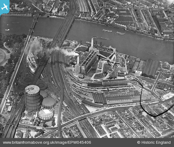
EPW045406 ENGLAND (1934). Battersea Power Station and environs, Battersea, 1934. This image has been produced from a damaged negative.
© Hawlfraint cyfranwyr OpenStreetMap a thrwyddedwyd gan yr OpenStreetMap Foundation. 2025. Trwyddedir y gartograffeg fel CC BY-SA.
Delweddau cyfagos (18)
Manylion
| Pennawd | [EPW045406] Battersea Power Station and environs, Battersea, 1934. This image has been produced from a damaged negative. |
| Cyfeirnod | EPW045406 |
| Dyddiad | July-1934 |
| Dolen | |
| Enw lle | BATTERSEA |
| Plwyf | |
| Ardal | |
| Gwlad | ENGLAND |
| Dwyreiniad / Gogleddiad | 528920, 177458 |
| Hydred / Lledred | -0.14322993938101, 51.480880509091 |
| Cyfeirnod Grid Cenedlaethol | TQ289775 |
Pinnau
 birdwatc10her |
Tuesday 22nd of September 2020 09:11:26 PM | |
 Chris Long |
Friday 28th of August 2020 04:17:18 PM | |
 brianbeckett |
Tuesday 30th of September 2014 04:47:38 PM | |
 brianbeckett |
Monday 22nd of September 2014 02:34:41 PM | |
 MB |
Saturday 5th of July 2014 10:10:25 AM | |
 MB |
Saturday 5th of July 2014 10:09:44 AM | |
 Alan McFaden |
Sunday 4th of May 2014 07:31:52 PM | |
 Alan McFaden |
Friday 18th of April 2014 09:38:09 AM | |
 Alan McFaden |
Friday 18th of April 2014 09:37:40 AM | |
The Victorua Bridge in 1934 but after reconsruction in the 1960s, the Grosvenor. |
 brianbeckett |
Monday 22nd of September 2014 02:33:38 PM |
 Alan McFaden |
Friday 18th of April 2014 09:37:05 AM | |
 Robin |
Friday 29th of November 2013 07:17:38 PM | |
 Robin |
Friday 29th of November 2013 07:10:59 PM | |
 Robin |
Friday 29th of November 2013 06:49:03 PM | |
 Robin |
Friday 29th of November 2013 06:22:19 PM | |
 Robin |
Friday 29th of November 2013 06:19:00 PM | |
 Robin |
Friday 29th of November 2013 06:07:13 PM | |
 Robin |
Friday 29th of November 2013 05:56:59 PM | |
 Robin |
Friday 29th of November 2013 05:36:24 PM | |
 Robin |
Thursday 28th of November 2013 05:04:43 PM | |
 Robin |
Thursday 28th of November 2013 04:56:12 PM | |
 Robin |
Thursday 28th of November 2013 04:51:23 PM | |
 Robin |
Thursday 28th of November 2013 04:33:21 PM | |
 MB |
Tuesday 5th of November 2013 05:23:40 PM | |
 Alan McFaden |
Sunday 26th of May 2013 06:45:41 PM | |
 Alan McFaden |
Sunday 26th of May 2013 06:44:41 PM |
Cyfraniadau Grŵp
Battersea Power Station from Vauxhall Bridge 08/04/2014 |
 Class31 |
Thursday 10th of April 2014 08:44:32 PM |


![[EPW045406] Battersea Power Station and environs, Battersea, 1934. This image has been produced from a damaged negative.](http://britainfromabove.org.uk/sites/all/libraries/aerofilms-images/public/100x100/EPW/045/EPW045406.jpg)
![[EPW040850] Battersea Power Station and environs, Nine Elms, 1933](http://britainfromabove.org.uk/sites/all/libraries/aerofilms-images/public/100x100/EPW/040/EPW040850.jpg)
![[EAW000577] Battersea Power Station, Nine Elms, 1946. This image has been produced from a print.](http://britainfromabove.org.uk/sites/all/libraries/aerofilms-images/public/100x100/EAW/000/EAW000577.jpg)
![[EPW043592] Battersea Power Station alongside the River Thames, Battersea, 1933. This image has been produced from a copy-negative.](http://britainfromabove.org.uk/sites/all/libraries/aerofilms-images/public/100x100/EPW/043/EPW043592.jpg)
![[EAW048056] Smoke billowing from a darkened Battersea Power Station, Battersea, 1952](http://britainfromabove.org.uk/sites/all/libraries/aerofilms-images/public/100x100/EAW/048/EAW048056.jpg)
![[EAW048058] Smoke billowing from Battersea Power Station and the River Thames, Battersea, from the south-west, 1952](http://britainfromabove.org.uk/sites/all/libraries/aerofilms-images/public/100x100/EAW/048/EAW048058.jpg)
![[EPW045385] The view over Battersea and Clapham towards Dulwich, Battersea, from the north-west, 1934](http://britainfromabove.org.uk/sites/all/libraries/aerofilms-images/public/100x100/EPW/045/EPW045385.jpg)
![[EPW040849] Battersea Power Station and environs, Nine Elms, 1933](http://britainfromabove.org.uk/sites/all/libraries/aerofilms-images/public/100x100/EPW/040/EPW040849.jpg)
![[EAW048057] Smoke billowing from Battersea Power Station, Battersea, 1952](http://britainfromabove.org.uk/sites/all/libraries/aerofilms-images/public/100x100/EAW/048/EAW048057.jpg)
![[EPW040851] Battersea Power Station and environs, Nine Elms, 1933](http://britainfromabove.org.uk/sites/all/libraries/aerofilms-images/public/100x100/EPW/040/EPW040851.jpg)
![[EAW036842] Battersea Power Station, Nine Elms, 1951. This image has been produced from a print.](http://britainfromabove.org.uk/sites/all/libraries/aerofilms-images/public/100x100/EAW/036/EAW036842.jpg)
![[EPW043591] Battersea Power Station alongside the River Thames, Battersea, 1933](http://britainfromabove.org.uk/sites/all/libraries/aerofilms-images/public/100x100/EPW/043/EPW043591.jpg)
![[EPW057999] A cityscape over Battersea Power Station and Chelsea, Nine Elms, from the south-east, 1938. This image has been produced from a print.](http://britainfromabove.org.uk/sites/all/libraries/aerofilms-images/public/100x100/EPW/057/EPW057999.jpg)
![[EAW000576] Battersea Power Station, Nine Elms, 1946. This image has been produced from a print.](http://britainfromabove.org.uk/sites/all/libraries/aerofilms-images/public/100x100/EAW/000/EAW000576.jpg)
![[EPW024270] Great Western Railway Goods Depot, Nine Elms, 1928](http://britainfromabove.org.uk/sites/all/libraries/aerofilms-images/public/100x100/EPW/024/EPW024270.jpg)
![[EAW034749] Battersea Gas Holder Station, Battersea Power Station and environs, Nine Elms, 1951](http://britainfromabove.org.uk/sites/all/libraries/aerofilms-images/public/100x100/EAW/034/EAW034749.jpg)
![[EPW059348] Battersea Power Station, Victoria Bridge and the city, Nine Elms, from the south-east, 1938](http://britainfromabove.org.uk/sites/all/libraries/aerofilms-images/public/100x100/EPW/059/EPW059348.jpg)
![[EPW058000] Battersea Power Station and Gas Holder Station, Nine Elms, 1938. This image has been produced from a print.](http://britainfromabove.org.uk/sites/all/libraries/aerofilms-images/public/100x100/EPW/058/EPW058000.jpg)


 RAILWAY BRIDGE_2.jpg?itok=wWSy_gWn)


