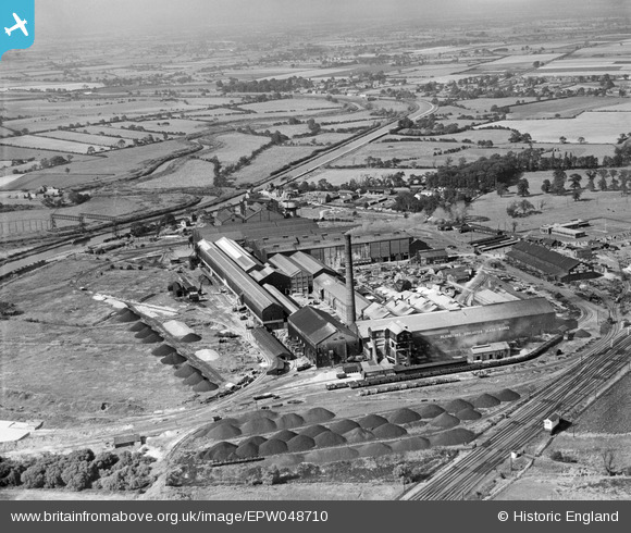
EPW048710 ENGLAND (1935). The Pilkington Brothers Doncaster Glass Works, Kirk Sandall, 1935
© Hawlfraint cyfranwyr OpenStreetMap a thrwyddedwyd gan yr OpenStreetMap Foundation. 2025. Trwyddedir y gartograffeg fel CC BY-SA.
Delweddau cyfagos (23)
Manylion
| Pennawd | [EPW048710] The Pilkington Brothers Doncaster Glass Works, Kirk Sandall, 1935 |
| Cyfeirnod | EPW048710 |
| Dyddiad | July-1935 |
| Dolen | |
| Enw lle | KIRK SANDALL |
| Plwyf | BARNBY DUN WITH KIRK SANDALL |
| Ardal | |
| Gwlad | ENGLAND |
| Dwyreiniad / Gogleddiad | 460864, 407779 |
| Hydred / Lledred | -1.0809811441846, 53.562850356352 |
| Cyfeirnod Grid Cenedlaethol | SE609078 |
Pinnau
 gwimages |
Tuesday 8th of February 2022 10:48:54 AM | |
 Rob Daniels |
Monday 30th of December 2019 01:42:14 PM | |
 Rob Daniels |
Monday 30th of December 2019 01:38:55 PM | |
 Rob Daniels |
Monday 30th of December 2019 01:37:04 PM |


![[EPW048710] The Pilkington Brothers Doncaster Glass Works, Kirk Sandall, 1935](http://britainfromabove.org.uk/sites/all/libraries/aerofilms-images/public/100x100/EPW/048/EPW048710.jpg)
![[EPW061662] The Pilkington Brothers Doncaster Glass Works and the surrounding countryside, Kirk Sandall, 1939](http://britainfromabove.org.uk/sites/all/libraries/aerofilms-images/public/100x100/EPW/061/EPW061662.jpg)
![[EPW048712] The Pilkington Brothers Doncaster Glass Works, Kirk Sandall, 1935](http://britainfromabove.org.uk/sites/all/libraries/aerofilms-images/public/100x100/EPW/048/EPW048712.jpg)
![[EPW061652] The Pilkington Brothers Doncaster Glass Works, Kirk Sandall, 1939](http://britainfromabove.org.uk/sites/all/libraries/aerofilms-images/public/100x100/EPW/061/EPW061652.jpg)
![[EPW048702] The Pilkington Brothers Doncaster Glass Works, Kirk Sandall, 1935](http://britainfromabove.org.uk/sites/all/libraries/aerofilms-images/public/100x100/EPW/048/EPW048702.jpg)
![[EPW048706] The Pilkington Brothers Doncaster Glass Works, Kirk Sandall, 1935](http://britainfromabove.org.uk/sites/all/libraries/aerofilms-images/public/100x100/EPW/048/EPW048706.jpg)
![[EPW048711] The Pilkington Brothers Doncaster Glass Works, Kirk Sandall, 1935](http://britainfromabove.org.uk/sites/all/libraries/aerofilms-images/public/100x100/EPW/048/EPW048711.jpg)
![[EPW048704] The Pilkington Brothers Doncaster Glass Works and the village, Kirk Sandall, from the west, 1935](http://britainfromabove.org.uk/sites/all/libraries/aerofilms-images/public/100x100/EPW/048/EPW048704.jpg)
![[EPW048709] The Pilkington Brothers Doncaster Glass Works, Kirk Sandall, 1935](http://britainfromabove.org.uk/sites/all/libraries/aerofilms-images/public/100x100/EPW/048/EPW048709.jpg)
![[EPW061654] The Pilkington Brothers Doncaster Glass Works, Kirk Sandall, 1939](http://britainfromabove.org.uk/sites/all/libraries/aerofilms-images/public/100x100/EPW/061/EPW061654.jpg)
![[EPW061657] The Pilkington Brothers Doncaster Glass Works and the surrounding countryside, Kirk Sandall, 1939](http://britainfromabove.org.uk/sites/all/libraries/aerofilms-images/public/100x100/EPW/061/EPW061657.jpg)
![[EPW061659] The Pilkington Brothers Doncaster Glass Works, Kirk Sandall, 1939](http://britainfromabove.org.uk/sites/all/libraries/aerofilms-images/public/100x100/EPW/061/EPW061659.jpg)
![[EPW048705] The Pilkington Brothers Doncaster Glass Works and the village, Kirk Sandall, from the west, 1935](http://britainfromabove.org.uk/sites/all/libraries/aerofilms-images/public/100x100/EPW/048/EPW048705.jpg)
![[EPW061660] The Pilkington Brothers Doncaster Glass Works and the surrounding countryside, Kirk Sandall, 1939](http://britainfromabove.org.uk/sites/all/libraries/aerofilms-images/public/100x100/EPW/061/EPW061660.jpg)
![[EPW061664] The Pilkington Brothers Doncaster Glass Works, Kirk Sandall, 1939](http://britainfromabove.org.uk/sites/all/libraries/aerofilms-images/public/100x100/EPW/061/EPW061664.jpg)
![[EPW048708] The Pilkington Brothers Doncaster Glass Works, Kirk Sandall, from the north, 1935](http://britainfromabove.org.uk/sites/all/libraries/aerofilms-images/public/100x100/EPW/048/EPW048708.jpg)
![[EPW061663] The Pilkington Brothers Doncaster Glass Works, Kirk Sandall, 1939](http://britainfromabove.org.uk/sites/all/libraries/aerofilms-images/public/100x100/EPW/061/EPW061663.jpg)
![[EPW048713] The Pilkington Brothers Doncaster Glass Works, Kirk Sandall, 1935](http://britainfromabove.org.uk/sites/all/libraries/aerofilms-images/public/100x100/EPW/048/EPW048713.jpg)
![[EPW061661] The Pilkington Brothers Doncaster Glass Works and the surrounding countryside, Kirk Sandall, 1939](http://britainfromabove.org.uk/sites/all/libraries/aerofilms-images/public/100x100/EPW/061/EPW061661.jpg)
![[EPW061656] The Pilkington Brothers Doncaster Glass Works and the surrounding countryside, Kirk Sandall, 1939](http://britainfromabove.org.uk/sites/all/libraries/aerofilms-images/public/100x100/EPW/061/EPW061656.jpg)
![[EPW061658] The Pilkington Brothers Doncaster Glass Works and housing off Lancaster Avenue, Kirk Sandall, 1939](http://britainfromabove.org.uk/sites/all/libraries/aerofilms-images/public/100x100/EPW/061/EPW061658.jpg)
![[EPW061653] The Pilkington Brothers Doncaster Glass Works, Kirk Sandall, from the south, 1939](http://britainfromabove.org.uk/sites/all/libraries/aerofilms-images/public/100x100/EPW/061/EPW061653.jpg)
![[EPW061655] The Pilkington Brothers Doncaster Glass Works and the surrounding countryside, Kirk Sandall, 1939](http://britainfromabove.org.uk/sites/all/libraries/aerofilms-images/public/100x100/EPW/061/EPW061655.jpg)
