
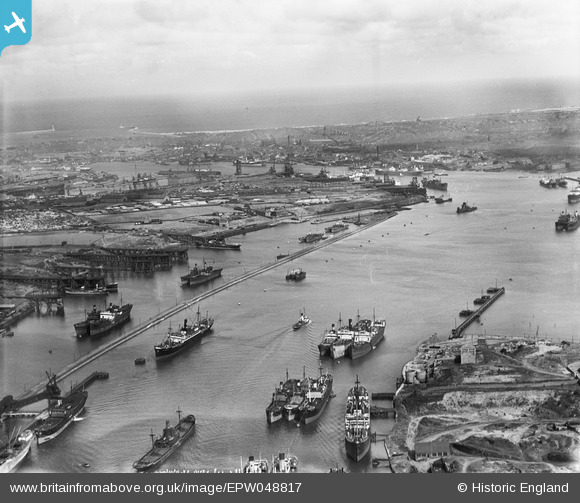
EPW048817 ENGLAND (1935). Northumberland Dock, the River Tyne and environs, East Howdon, from the south-west, 1935
© Hawlfraint cyfranwyr OpenStreetMap a thrwyddedwyd gan yr OpenStreetMap Foundation. 2025. Trwyddedir y gartograffeg fel CC BY-SA.
Delweddau cyfagos (3)
EPW048817

EAW050677

EAW050685

Manylion
| Pennawd | [EPW048817] Northumberland Dock, the River Tyne and environs, East Howdon, from the south-west, 1935 |
| Cyfeirnod | EPW048817 |
| Dyddiad | August-1935 |
| Dolen | |
| Enw lle | EAST HOWDON |
| Plwyf | |
| Ardal | |
| Gwlad | ENGLAND |
| Dwyreiniad / Gogleddiad | 433763, 566045 |
| Hydred / Lledred | -1.4723004187943, 54.987777741619 |
| Cyfeirnod Grid Cenedlaethol | NZ338660 |
Pinnau
 |
 N Dunn |
Thursday 9th of January 2014 01:43:33 PM |
 |
N Dunn |
Thursday 9th of January 2014 01:40:46 PM |
Eric Hollerton |
Sunday 28th of July 2013 06:23:29 PM | |
Eric Hollerton |
Sunday 28th of July 2013 06:22:31 PM | |
 Dylan Moore |
Sunday 5th of May 2013 05:06:04 PM |