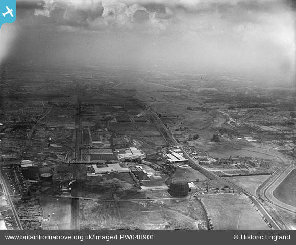
EPW048901 ENGLAND (1935). The Gothic Gas Meters and Stove Works and the site of the William Girling Reservoir, Upper Edmonton, from the south, 1935
© Hawlfraint cyfranwyr OpenStreetMap a thrwyddedwyd gan yr OpenStreetMap Foundation. 2024. Trwyddedir y gartograffeg fel CC BY-SA.
Delweddau cyfagos (31)
Manylion
| Pennawd | [EPW048901] The Gothic Gas Meters and Stove Works and the site of the William Girling Reservoir, Upper Edmonton, from the south, 1935 |
| Cyfeirnod | EPW048901 |
| Dyddiad | August-1935 |
| Dolen | |
| Enw lle | UPPER EDMONTON |
| Plwyf | |
| Ardal | |
| Gwlad | ENGLAND |
| Dwyreiniad / Gogleddiad | 535508, 192022 |
| Hydred / Lledred | -0.042794450881412, 51.610229956003 |
| Cyfeirnod Grid Cenedlaethol | TQ355920 |
Pinnau
Byddwch y cyntaf i ychwanegu sylw at y ddelwedd hon!


![[EPW048901] The Gothic Gas Meters and Stove Works and the site of the William Girling Reservoir, Upper Edmonton, from the south, 1935](http://britainfromabove.org.uk/sites/all/libraries/aerofilms-images/public/100x100/EPW/048/EPW048901.jpg)
![[EPW044752] The Gothic Gas Meter and Stove Works, Edmonton, 1934](http://britainfromabove.org.uk/sites/all/libraries/aerofilms-images/public/100x100/EPW/044/EPW044752.jpg)
![[EPW044749] The Gothic Gas Meter and Stove Works, Edmonton, 1934](http://britainfromabove.org.uk/sites/all/libraries/aerofilms-images/public/100x100/EPW/044/EPW044749.jpg)
![[EPW044758] The Gothic Gas Meter and Stove Works, Edmonton, 1934](http://britainfromabove.org.uk/sites/all/libraries/aerofilms-images/public/100x100/EPW/044/EPW044758.jpg)
![[EPW044750] The Gothic Gas Meter and Stove Works, Edmonton, 1934](http://britainfromabove.org.uk/sites/all/libraries/aerofilms-images/public/100x100/EPW/044/EPW044750.jpg)
![[EPW044751] The Gothic Gas Meter and Stove Works, Edmonton, 1934](http://britainfromabove.org.uk/sites/all/libraries/aerofilms-images/public/100x100/EPW/044/EPW044751.jpg)
![[EPW044757] The Gothic Gas Meter and Stove Works, Edmonton, 1934](http://britainfromabove.org.uk/sites/all/libraries/aerofilms-images/public/100x100/EPW/044/EPW044757.jpg)
![[EPW044760] The Gothic Gas Meter and Stove Works and environs, Edmonton, 1934](http://britainfromabove.org.uk/sites/all/libraries/aerofilms-images/public/100x100/EPW/044/EPW044760.jpg)
![[EPW032038] The Gothic Gas Meters and Stove Works and environs, Edmonton, 1930](http://britainfromabove.org.uk/sites/all/libraries/aerofilms-images/public/100x100/EPW/032/EPW032038.jpg)
![[EPW049728] The Glover and Main Gothic Works (Gas Meters and Stoves) and other factories, Edmonton, 1936](http://britainfromabove.org.uk/sites/all/libraries/aerofilms-images/public/100x100/EPW/049/EPW049728.jpg)
![[EPW032042] The Gothic Gas Meters and Stove Works and environs, Edmonton, 1930](http://britainfromabove.org.uk/sites/all/libraries/aerofilms-images/public/100x100/EPW/032/EPW032042.jpg)
![[EPW044759] The Gothic Gas Meter and Stove Works, Edmonton, 1934](http://britainfromabove.org.uk/sites/all/libraries/aerofilms-images/public/100x100/EPW/044/EPW044759.jpg)
![[EPW056394] The Gothic Gas Meter and Stove Works and nearby factories off Angel Road, Edmonton, 1938. This image has been produced from a copy-negative.](http://britainfromabove.org.uk/sites/all/libraries/aerofilms-images/public/100x100/EPW/056/EPW056394.jpg)
![[EPW044761] The Gothic Gas Meter and Stove Works, Edmonton, 1934](http://britainfromabove.org.uk/sites/all/libraries/aerofilms-images/public/100x100/EPW/044/EPW044761.jpg)
![[EPW032759] T. Glover and Co Gothic Gas Meter and Stove Works, Edmonton, 1930](http://britainfromabove.org.uk/sites/all/libraries/aerofilms-images/public/100x100/EPW/032/EPW032759.jpg)
![[EPW032043] The Gothic Gas Meters and Stove Works and environs, Edmonton, 1930](http://britainfromabove.org.uk/sites/all/libraries/aerofilms-images/public/100x100/EPW/032/EPW032043.jpg)
![[EPW032762] T. Glover and Co Gothic Gas Meter and Stove Works, Edmonton, 1930](http://britainfromabove.org.uk/sites/all/libraries/aerofilms-images/public/100x100/EPW/032/EPW032762.jpg)
![[EPW032039] The Gothic Gas Meters and Stove Works and environs, Edmonton, 1930](http://britainfromabove.org.uk/sites/all/libraries/aerofilms-images/public/100x100/EPW/032/EPW032039.jpg)
![[EPW048900] The Gothic Gas Meters and Stove Works, the Sparklet Works and the site of the William Girling Reservoir, Upper Edmonton, from the south, 1935](http://britainfromabove.org.uk/sites/all/libraries/aerofilms-images/public/100x100/EPW/048/EPW048900.jpg)
![[EPW032037] The Gothic Gas Meters and Stove Works and environs, Edmonton, 1930](http://britainfromabove.org.uk/sites/all/libraries/aerofilms-images/public/100x100/EPW/032/EPW032037.jpg)
![[EPW042088] The Rego Clothiers Ltd factory on Angel Road, Edmonton, 1933](http://britainfromabove.org.uk/sites/all/libraries/aerofilms-images/public/100x100/EPW/042/EPW042088.jpg)
![[EPW032757] T. Glover and Co Gothic Gas Meter and Stove Works, Edmonton, 1930](http://britainfromabove.org.uk/sites/all/libraries/aerofilms-images/public/100x100/EPW/032/EPW032757.jpg)
![[EPW044756] The Gothic Gas Meter and Stove Works, Edmonton, 1934](http://britainfromabove.org.uk/sites/all/libraries/aerofilms-images/public/100x100/EPW/044/EPW044756.jpg)
![[EPW032763] T. Glover and Co Gothic Gas Meter and Stove Works, Edmonton, 1930](http://britainfromabove.org.uk/sites/all/libraries/aerofilms-images/public/100x100/EPW/032/EPW032763.jpg)
![[EPW044755] The Gothic Gas Meter and Stove Works and environs, Edmonton, 1934](http://britainfromabove.org.uk/sites/all/libraries/aerofilms-images/public/100x100/EPW/044/EPW044755.jpg)
![[EPW032758] T. Glover and Co Gothic Gas Meter and Stove Works, Edmonton, 1930](http://britainfromabove.org.uk/sites/all/libraries/aerofilms-images/public/100x100/EPW/032/EPW032758.jpg)
![[EPW032761] T. Glover and Co Gothic Gas Meter and Stove Works, Edmonton, 1930](http://britainfromabove.org.uk/sites/all/libraries/aerofilms-images/public/100x100/EPW/032/EPW032761.jpg)
![[EPW032760] T. Glover and Co Gothic Gas Meter and Stove Works, Edmonton, 1930](http://britainfromabove.org.uk/sites/all/libraries/aerofilms-images/public/100x100/EPW/032/EPW032760.jpg)
![[EPW032764] T. Glover and Co Gothic Gas Meter and Stove Works, Edmonton, 1930](http://britainfromabove.org.uk/sites/all/libraries/aerofilms-images/public/100x100/EPW/032/EPW032764.jpg)
![[EPW032044] The Gothic Gas Meters and Stove Works and environs, Edmonton, 1930](http://britainfromabove.org.uk/sites/all/libraries/aerofilms-images/public/100x100/EPW/032/EPW032044.jpg)
![[EPW044753] The Gothic Gas Meter and Stove Works, Edmonton, 1934](http://britainfromabove.org.uk/sites/all/libraries/aerofilms-images/public/100x100/EPW/044/EPW044753.jpg)