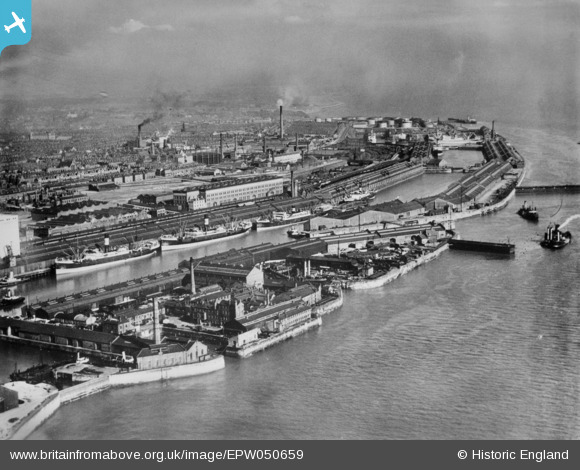
EPW050659 ENGLAND (1936). Brunswick, Toxteth and Harrington Docks, Liverpool, from the north-west, 1936. This image has been produced from a copy-negative.
© Hawlfraint cyfranwyr OpenStreetMap a thrwyddedwyd gan yr OpenStreetMap Foundation. 2025. Trwyddedir y gartograffeg fel CC BY-SA.
Delweddau cyfagos (6)
Manylion
| Pennawd | [EPW050659] Brunswick, Toxteth and Harrington Docks, Liverpool, from the north-west, 1936. This image has been produced from a copy-negative. |
| Cyfeirnod | EPW050659 |
| Dyddiad | June-1936 |
| Dolen | |
| Enw lle | LIVERPOOL |
| Plwyf | |
| Ardal | |
| Gwlad | ENGLAND |
| Dwyreiniad / Gogleddiad | 334499, 388355 |
| Hydred / Lledred | -2.984972956506, 53.387705894011 |
| Cyfeirnod Grid Cenedlaethol | SJ345884 |
Pinnau
Byddwch y cyntaf i ychwanegu sylw at y ddelwedd hon!


![[EPW050659] Brunswick, Toxteth and Harrington Docks, Liverpool, from the north-west, 1936. This image has been produced from a copy-negative.](http://britainfromabove.org.uk/sites/all/libraries/aerofilms-images/public/100x100/EPW/050/EPW050659.jpg)
![[EPW018904] Brunswick and Toxteth Docks, Toxteth, 1927](http://britainfromabove.org.uk/sites/all/libraries/aerofilms-images/public/100x100/EPW/018/EPW018904.jpg)
![[EAW399274] Brunswick Dock, Liverpool, 1980](http://britainfromabove.org.uk/sites/all/libraries/aerofilms-images/public/100x100/EAW/399/EAW399274.jpg)
![[EPR000321] Brunswick Dock and the city, Liverpool, from the south-west, 1934](http://britainfromabove.org.uk/sites/all/libraries/aerofilms-images/public/100x100/EPR/000/EPR000321.jpg)
![[EPW018909] Coburg, Brunswick and Toxteth Docks, Toxteth, 1927](http://britainfromabove.org.uk/sites/all/libraries/aerofilms-images/public/100x100/EPW/018/EPW018909.jpg)
![[EPW050660] Brunswick Dock and Liverpool Cathedral under construction in the distance, Liverpool, from the south-west, 1936](http://britainfromabove.org.uk/sites/all/libraries/aerofilms-images/public/100x100/EPW/050/EPW050660.jpg)