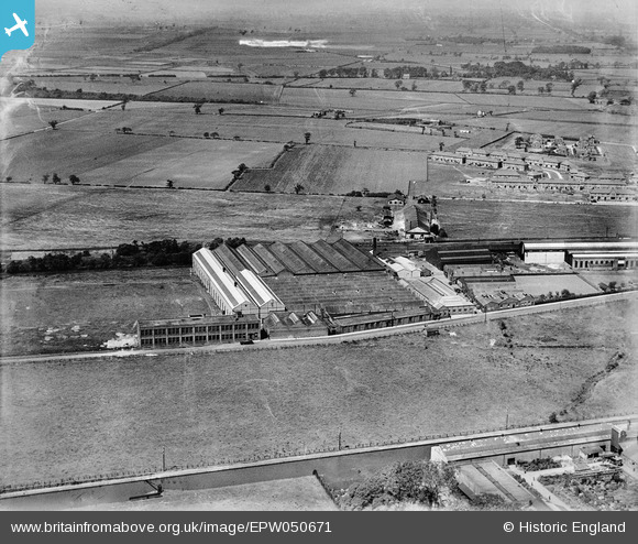
EPW050671 ENGLAND (1936). The Churchill Machine Tool Works, Broadheath, 1936. This image was marked by Aerofilms Ltd for photo editing.
© Hawlfraint cyfranwyr OpenStreetMap a thrwyddedwyd gan yr OpenStreetMap Foundation. 2025. Trwyddedir y gartograffeg fel CC BY-SA.
Delweddau cyfagos (15)
Manylion
| Pennawd | [EPW050671] The Churchill Machine Tool Works, Broadheath, 1936. This image was marked by Aerofilms Ltd for photo editing. |
| Cyfeirnod | EPW050671 |
| Dyddiad | June-1936 |
| Dolen | |
| Enw lle | BROADHEATH |
| Plwyf | |
| Ardal | |
| Gwlad | ENGLAND |
| Dwyreiniad / Gogleddiad | 375919, 389108 |
| Hydred / Lledred | -2.3622014974032, 53.397988580323 |
| Cyfeirnod Grid Cenedlaethol | SJ759891 |
Pinnau
 Fire123 |
Thursday 5th of November 2015 02:48:47 PM | |
 Fire123 |
Thursday 5th of November 2015 02:45:40 PM | |
 Fire123 |
Thursday 5th of November 2015 02:44:32 PM | |
 Fire123 |
Thursday 5th of November 2015 02:40:21 PM | |
 Fire123 |
Wednesday 4th of November 2015 01:55:11 PM | |
 Fire123 |
Wednesday 4th of November 2015 01:46:50 PM | |
 Fire123 |
Wednesday 4th of November 2015 10:24:11 AM | |
 Fire123 |
Wednesday 4th of November 2015 10:23:42 AM |


![[EPW050671] The Churchill Machine Tool Works, Broadheath, 1936. This image was marked by Aerofilms Ltd for photo editing.](http://britainfromabove.org.uk/sites/all/libraries/aerofilms-images/public/100x100/EPW/050/EPW050671.jpg)
![[EPW050670] The Churchill Machine Tool Works, Broadheath, 1936. This image was marked by Aerofilms Ltd for photo editing.](http://britainfromabove.org.uk/sites/all/libraries/aerofilms-images/public/100x100/EPW/050/EPW050670.jpg)
![[EPW050021] The Churchill Machine Tool Works, Broadheath, 1936. This image has been produced from a print.](http://britainfromabove.org.uk/sites/all/libraries/aerofilms-images/public/100x100/EPW/050/EPW050021.jpg)
![[EPW050673] The Churchill Machine Tool Works, Broadheath, 1936](http://britainfromabove.org.uk/sites/all/libraries/aerofilms-images/public/100x100/EPW/050/EPW050673.jpg)
![[EPW038468] The Churchill Machine Tool Works, Broadheath, 1932. This image has been produced from a print.](http://britainfromabove.org.uk/sites/all/libraries/aerofilms-images/public/100x100/EPW/038/EPW038468.jpg)
![[EPW038470] The Churchill Machine Tool Works, Broadheath, 1932. This image has been produced from a damaged negative.](http://britainfromabove.org.uk/sites/all/libraries/aerofilms-images/public/100x100/EPW/038/EPW038470.jpg)
![[EPW050672] The Churchill Machine Tool Works, Broadheath, from the south-west, 1936](http://britainfromabove.org.uk/sites/all/libraries/aerofilms-images/public/100x100/EPW/050/EPW050672.jpg)
![[EAW031523] The H. W. Kearns and Co Ltd Engineering Works and environs, Broadheath, 1950](http://britainfromabove.org.uk/sites/all/libraries/aerofilms-images/public/100x100/EAW/031/EAW031523.jpg)
![[EAW031526] The H. W. Kearns and Co Ltd Engineering Works and environs, Broadheath, 1950. This image was marked by Aerofilms Ltd for photo editing.](http://britainfromabove.org.uk/sites/all/libraries/aerofilms-images/public/100x100/EAW/031/EAW031526.jpg)
![[EAW031528] The H. W. Kearns and Co Ltd Engineering Works and environs, Broadheath, 1950. This image was marked by Aerofilms Ltd for photo editing.](http://britainfromabove.org.uk/sites/all/libraries/aerofilms-images/public/100x100/EAW/031/EAW031528.jpg)
![[EAW031522] The H. W. Kearns and Co Ltd Engineering Works, Broadheath, 1950. This image was marked by Aerofilms Ltd for photo editing.](http://britainfromabove.org.uk/sites/all/libraries/aerofilms-images/public/100x100/EAW/031/EAW031522.jpg)
![[EAW031524] The H. W. Kearns and Co Ltd Engineering Works, Broadheath, 1950](http://britainfromabove.org.uk/sites/all/libraries/aerofilms-images/public/100x100/EAW/031/EAW031524.jpg)
![[EAW031521] The H. W. Kearns and Co Ltd Engineering Works, Broadheath, 1950. This image was marked by Aerofilms Ltd for photo editing.](http://britainfromabove.org.uk/sites/all/libraries/aerofilms-images/public/100x100/EAW/031/EAW031521.jpg)
![[EAW031527] The H. W. Kearns and Co Ltd Engineering Works and environs, Broadheath, 1950. This image was marked by Aerofilms Ltd for photo editing.](http://britainfromabove.org.uk/sites/all/libraries/aerofilms-images/public/100x100/EAW/031/EAW031527.jpg)
![[EAW031525] The H. W. Kearns and Co Ltd Engineering Works, Broadheath, 1950. This image was marked by Aerofilms Ltd for photo editing.](http://britainfromabove.org.uk/sites/all/libraries/aerofilms-images/public/100x100/EAW/031/EAW031525.jpg)