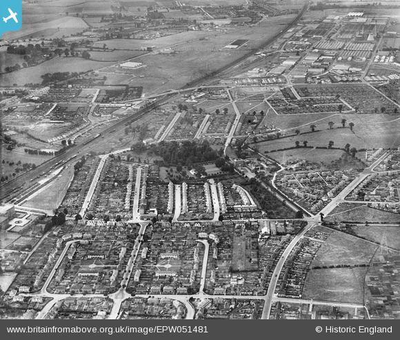
EPW051481 ENGLAND (1936). Housing development around Baylis House and environs, Slough, 1936
© Hawlfraint cyfranwyr OpenStreetMap a thrwyddedwyd gan yr OpenStreetMap Foundation. 2025. Trwyddedir y gartograffeg fel CC BY-SA.
Manylion
| Pennawd | [EPW051481] Housing development around Baylis House and environs, Slough, 1936 |
| Cyfeirnod | EPW051481 |
| Dyddiad | August-1936 |
| Dolen | |
| Enw lle | SLOUGH |
| Plwyf | |
| Ardal | |
| Gwlad | ENGLAND |
| Dwyreiniad / Gogleddiad | 496909, 180774 |
| Hydred / Lledred | -0.6031856410388, 51.51708315611 |
| Cyfeirnod Grid Cenedlaethol | SU969808 |
Pinnau
 Mike Holder |
Thursday 1st of February 2018 06:01:52 PM | |
 nikksie |
Wednesday 2nd of March 2016 03:49:41 PM | |
 nikksie |
Wednesday 2nd of March 2016 03:46:37 PM | |
 nikksie |
Wednesday 2nd of March 2016 03:45:55 PM | |
 nikksie |
Wednesday 2nd of March 2016 03:43:17 PM | |
 nikksie |
Wednesday 2nd of March 2016 03:43:12 PM | |
 Class31 |
Tuesday 16th of July 2013 10:45:05 PM | |
 Class31 |
Tuesday 16th of July 2013 10:43:09 PM | |
 Class31 |
Tuesday 16th of July 2013 10:39:12 PM | |
 payitforwardeddie |
Wednesday 29th of May 2013 06:06:53 AM | |
 payitforwardeddie |
Wednesday 29th of May 2013 06:05:08 AM | |
 payitforwardeddie |
Wednesday 29th of May 2013 06:03:37 AM | |
 Mike Holder |
Saturday 18th of May 2013 12:31:38 PM | |
 Mike Holder |
Saturday 18th of May 2013 12:25:47 PM | |
 Mike Holder |
Saturday 18th of May 2013 12:23:18 PM | |
 Mike Holder |
Thursday 16th of May 2013 06:36:43 PM | |
 Mike Holder |
Thursday 16th of May 2013 06:33:37 PM | |
 Mike Holder |
Thursday 16th of May 2013 06:28:04 PM | |
 Mike Holder |
Thursday 16th of May 2013 06:25:31 PM |


![[EPW051481] Housing development around Baylis House and environs, Slough, 1936](http://britainfromabove.org.uk/sites/all/libraries/aerofilms-images/public/100x100/EPW/051/EPW051481.jpg)
![[EPW051482] Housing development around Baylis House and environs, Slough, 1936](http://britainfromabove.org.uk/sites/all/libraries/aerofilms-images/public/100x100/EPW/051/EPW051482.jpg)


