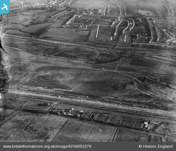
EPW052279 ENGLAND (1936). The site of the William Girling Reservoir showing preliminary construction works, Edmonton, 1936. This image has been produced from a damaged negative.
© Hawlfraint cyfranwyr OpenStreetMap a thrwyddedwyd gan yr OpenStreetMap Foundation. 2025. Trwyddedir y gartograffeg fel CC BY-SA.
Delweddau cyfagos (38)
Manylion
| Pennawd | [EPW052279] The site of the William Girling Reservoir showing preliminary construction works, Edmonton, 1936. This image has been produced from a damaged negative. |
| Cyfeirnod | EPW052279 |
| Dyddiad | November-1936 |
| Dolen | |
| Enw lle | EDMONTON |
| Plwyf | |
| Ardal | |
| Gwlad | ENGLAND |
| Dwyreiniad / Gogleddiad | 536587, 193620 |
| Hydred / Lledred | -0.026596863277154, 51.624330398512 |
| Cyfeirnod Grid Cenedlaethol | TQ366936 |
Pinnau
Byddwch y cyntaf i ychwanegu sylw at y ddelwedd hon!


![[EPW052279] The site of the William Girling Reservoir showing preliminary construction works, Edmonton, 1936. This image has been produced from a damaged negative.](http://britainfromabove.org.uk/sites/all/libraries/aerofilms-images/public/100x100/EPW/052/EPW052279.jpg)
![[EPW052286] The site of the William Girling Reservoir showing preliminary construction works, Edmonton, 1936](http://britainfromabove.org.uk/sites/all/libraries/aerofilms-images/public/100x100/EPW/052/EPW052286.jpg)
![[EPW048912] The site of the William Girling Reservoir, Lower Edmonton, 1935. This image has been produced from a damaged negative.](http://britainfromabove.org.uk/sites/all/libraries/aerofilms-images/public/100x100/EPW/048/EPW048912.jpg)
![[EPW060636] The William Girling Reservoir under construction, Lower Edmonton, 1939](http://britainfromabove.org.uk/sites/all/libraries/aerofilms-images/public/100x100/EPW/060/EPW060636.jpg)
![[EAW044489] The William Girling Reservoir, Ponders End, 1952](http://britainfromabove.org.uk/sites/all/libraries/aerofilms-images/public/100x100/EAW/044/EAW044489.jpg)
![[EPW055974] The William Girling Reservoir under construction, Lower Edmonton, 1937](http://britainfromabove.org.uk/sites/all/libraries/aerofilms-images/public/100x100/EPW/055/EPW055974.jpg)
![[EPW056812] The William Girling Reservoir under construction, Edmonton, 1938](http://britainfromabove.org.uk/sites/all/libraries/aerofilms-images/public/100x100/EPW/056/EPW056812.jpg)
![[EPW058458] The Chingford (William Girling) Reservoir under construction, Edmonton, 1938](http://britainfromabove.org.uk/sites/all/libraries/aerofilms-images/public/100x100/EPW/058/EPW058458.jpg)
![[EPW056318] The William Girling Reservoir under construction, Edmonton, 1938](http://britainfromabove.org.uk/sites/all/libraries/aerofilms-images/public/100x100/EPW/056/EPW056318.jpg)
![[EAW040924] The recently completed William Girling Reservoir beginning to fill up with water, Edmonton, 1951](http://britainfromabove.org.uk/sites/all/libraries/aerofilms-images/public/100x100/EAW/040/EAW040924.jpg)
![[EPW060628] The William Girling Reservoir under construction, Lower Edmonton, 1939](http://britainfromabove.org.uk/sites/all/libraries/aerofilms-images/public/100x100/EPW/060/EPW060628.jpg)
![[EPW055969] The William Girling Reservoir under construction, Lower Edmonton, 1937](http://britainfromabove.org.uk/sites/all/libraries/aerofilms-images/public/100x100/EPW/055/EPW055969.jpg)
![[EPW056824] The William Girling Reservoir under construction, Edmonton, 1938](http://britainfromabove.org.uk/sites/all/libraries/aerofilms-images/public/100x100/EPW/056/EPW056824.jpg)
![[EPW053844] The Chingford (William Girling) Reservoir under construction, Edmonton, 1937](http://britainfromabove.org.uk/sites/all/libraries/aerofilms-images/public/100x100/EPW/053/EPW053844.jpg)
![[EPW050857] The site of the southern end of the William Girling Reservoir showing preliminary construction works, Edmonton, 1936](http://britainfromabove.org.uk/sites/all/libraries/aerofilms-images/public/100x100/EPW/050/EPW050857.jpg)
![[EPW058472] The Chingford (William Girling) Reservoir under construction, Edmonton, 1938](http://britainfromabove.org.uk/sites/all/libraries/aerofilms-images/public/100x100/EPW/058/EPW058472.jpg)
![[EPW056322] The William Girling Reservoir under construction, Edmonton, 1938](http://britainfromabove.org.uk/sites/all/libraries/aerofilms-images/public/100x100/EPW/056/EPW056322.jpg)
![[EAW044486] The William Girling Reservoir, Ponders End, 1952](http://britainfromabove.org.uk/sites/all/libraries/aerofilms-images/public/100x100/EAW/044/EAW044486.jpg)
![[EPW060642] The William Girling Reservoir under construction and environs, Enfield, 1939](http://britainfromabove.org.uk/sites/all/libraries/aerofilms-images/public/100x100/EPW/060/EPW060642.jpg)
![[EPW060633] The William Girling Reservoir under construction, Enfield, 1939](http://britainfromabove.org.uk/sites/all/libraries/aerofilms-images/public/100x100/EPW/060/EPW060633.jpg)
![[EAW040927] The recently completed William Girling Reservoir beginning to fill up with water, Edmonton, 1951](http://britainfromabove.org.uk/sites/all/libraries/aerofilms-images/public/100x100/EAW/040/EAW040927.jpg)
![[EPW055970] The William Girling Reservoir under construction, Lower Edmonton, 1937](http://britainfromabove.org.uk/sites/all/libraries/aerofilms-images/public/100x100/EPW/055/EPW055970.jpg)
![[EPW060641] The William Girling Reservoir under construction and environs, Enfield, 1939](http://britainfromabove.org.uk/sites/all/libraries/aerofilms-images/public/100x100/EPW/060/EPW060641.jpg)
![[EPW056323] The William Girling Reservoir under construction, Edmonton, 1938](http://britainfromabove.org.uk/sites/all/libraries/aerofilms-images/public/100x100/EPW/056/EPW056323.jpg)
![[EPW055973] The William Girling Reservoir under construction, Lower Edmonton, 1937](http://britainfromabove.org.uk/sites/all/libraries/aerofilms-images/public/100x100/EPW/055/EPW055973.jpg)
![[EPW055972] The William Girling Reservoir under construction, Lower Edmonton, 1937](http://britainfromabove.org.uk/sites/all/libraries/aerofilms-images/public/100x100/EPW/055/EPW055972.jpg)
![[EPW053847] The Chingford (William Girling) Reservoir under construction, Edmonton, 1937](http://britainfromabove.org.uk/sites/all/libraries/aerofilms-images/public/100x100/EPW/053/EPW053847.jpg)
![[EPW056828] The William Girling Reservoir under construction, Edmonton, 1938](http://britainfromabove.org.uk/sites/all/libraries/aerofilms-images/public/100x100/EPW/056/EPW056828.jpg)
![[EPW060643] The William Girling Reservoir under construction, King George's Reservoir and environs, Enfield, 1939](http://britainfromabove.org.uk/sites/all/libraries/aerofilms-images/public/100x100/EPW/060/EPW060643.jpg)
![[EPW056324] The William Girling Reservoir under construction, Edmonton, 1938](http://britainfromabove.org.uk/sites/all/libraries/aerofilms-images/public/100x100/EPW/056/EPW056324.jpg)
![[EPW050865] The site of the William Girling Reservoir showing preliminary construction works, Edmonton, 1936](http://britainfromabove.org.uk/sites/all/libraries/aerofilms-images/public/100x100/EPW/050/EPW050865.jpg)
![[EPW055984] The William Girling Reservoir under construction at Pickett's Lock, Enfield, 1937](http://britainfromabove.org.uk/sites/all/libraries/aerofilms-images/public/100x100/EPW/055/EPW055984.jpg)
![[EPW058463] The Chingford (William Girling) Reservoir under construction, Edmonton, from the south, 1938](http://britainfromabove.org.uk/sites/all/libraries/aerofilms-images/public/100x100/EPW/058/EPW058463.jpg)
![[EPW060640] The William Girling Reservoir under construction, King George's Reservoir and environs, Enfield, 1939](http://britainfromabove.org.uk/sites/all/libraries/aerofilms-images/public/100x100/EPW/060/EPW060640.jpg)
![[EPW052281] The site of the William Girling Reservoir showing preliminary construction works, Edmonton, 1936. This image has been produced from a damaged negative.](http://britainfromabove.org.uk/sites/all/libraries/aerofilms-images/public/100x100/EPW/052/EPW052281.jpg)
![[EPW056317] The William Girling Reservoir under construction, Edmonton, from the south, 1938](http://britainfromabove.org.uk/sites/all/libraries/aerofilms-images/public/100x100/EPW/056/EPW056317.jpg)
![[EPW056327] The William Girling Reservoir under construction, Edmonton, 1938](http://britainfromabove.org.uk/sites/all/libraries/aerofilms-images/public/100x100/EPW/056/EPW056327.jpg)
![[EPW055985] The William Girling Reservoir under construction, Enfield, 1937](http://britainfromabove.org.uk/sites/all/libraries/aerofilms-images/public/100x100/EPW/055/EPW055985.jpg)