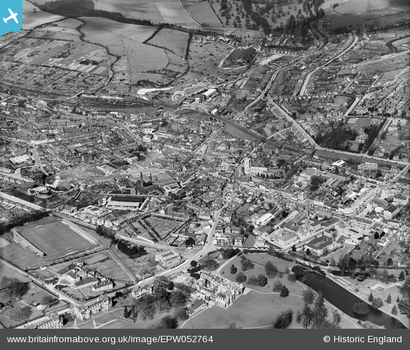
EPW052764 ENGLAND (1937). The town, High Wycombe, from the south, 1937
© Hawlfraint cyfranwyr OpenStreetMap a thrwyddedwyd gan yr OpenStreetMap Foundation. 2024. Trwyddedir y gartograffeg fel CC BY-SA.
Delweddau cyfagos (8)
Manylion
| Pennawd | [EPW052764] The town, High Wycombe, from the south, 1937 |
| Cyfeirnod | EPW052764 |
| Dyddiad | 24-March-1937 |
| Dolen | |
| Enw lle | HIGH WYCOMBE |
| Plwyf | |
| Ardal | |
| Gwlad | ENGLAND |
| Dwyreiniad / Gogleddiad | 486510, 192786 |
| Hydred / Lledred | -0.75007417809872, 51.626762863974 |
| Cyfeirnod Grid Cenedlaethol | SU865928 |
Pinnau
 John Saunders |
Thursday 13th of February 2014 11:59:10 AM | |
 John Saunders |
Thursday 13th of February 2014 11:57:57 AM | |
 John Saunders |
Thursday 13th of February 2014 11:55:37 AM | |
 John Saunders |
Thursday 13th of February 2014 11:50:50 AM | |
 John Saunders |
Thursday 13th of February 2014 11:46:25 AM | |
 John Saunders |
Thursday 13th of February 2014 11:45:49 AM | |
 John Saunders |
Thursday 13th of February 2014 11:44:51 AM | |
 John Saunders |
Thursday 13th of February 2014 11:42:11 AM | |
Apart from floodlights and proper terracing it didn't look any different the day it closed. |
 gBr |
Tuesday 6th of January 2015 10:23:55 PM |


![[EPW052764] The town, High Wycombe, from the south, 1937](http://britainfromabove.org.uk/sites/all/libraries/aerofilms-images/public/100x100/EPW/052/EPW052764.jpg)
![[EPW017821] The town centre including Wycombe Abbey, High Wycombe, from the south, 1927](http://britainfromabove.org.uk/sites/all/libraries/aerofilms-images/public/100x100/EPW/017/EPW017821.jpg)
![[EPW034492] Wycombe Abbey School and the War Memorial Hospital, High Wycombe, 1930](http://britainfromabove.org.uk/sites/all/libraries/aerofilms-images/public/100x100/EPW/034/EPW034492.jpg)
![[EPW034496] Wycombe Abbey School, High Wycombe, 1930](http://britainfromabove.org.uk/sites/all/libraries/aerofilms-images/public/100x100/EPW/034/EPW034496.jpg)
![[EPW052765] The town, High Wycombe, from the south-east, 1937](http://britainfromabove.org.uk/sites/all/libraries/aerofilms-images/public/100x100/EPW/052/EPW052765.jpg)
![[EPW017826] The town centre including Wycombe Abbey, High Wycombe, from the south, 1927](http://britainfromabove.org.uk/sites/all/libraries/aerofilms-images/public/100x100/EPW/017/EPW017826.jpg)
![[EPW034491] Wycombe Abbey School and environs, High Wycombe, 1930](http://britainfromabove.org.uk/sites/all/libraries/aerofilms-images/public/100x100/EPW/034/EPW034491.jpg)
![[EPW038415] Wycombe Abbey School and environs, Wycombe, 1932](http://britainfromabove.org.uk/sites/all/libraries/aerofilms-images/public/100x100/EPW/038/EPW038415.jpg)