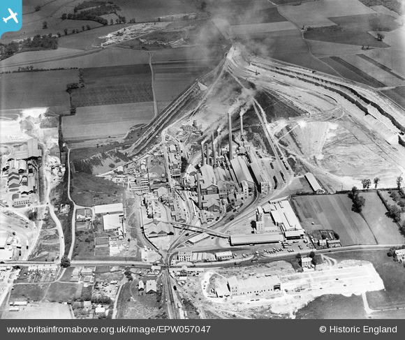
EPW057047 ENGLAND (1938). The Tunnel Portland Cement Works, West Thurrock, 1938
© Hawlfraint cyfranwyr OpenStreetMap a thrwyddedwyd gan yr OpenStreetMap Foundation. 2025. Trwyddedir y gartograffeg fel CC BY-SA.
Delweddau cyfagos (35)
Manylion
| Pennawd | [EPW057047] The Tunnel Portland Cement Works, West Thurrock, 1938 |
| Cyfeirnod | EPW057047 |
| Dyddiad | 12-May-1938 |
| Dolen | |
| Enw lle | WEST THURROCK |
| Plwyf | |
| Ardal | |
| Gwlad | ENGLAND |
| Dwyreiniad / Gogleddiad | 557683, 177987 |
| Hydred / Lledred | 0.27094731509229, 51.478346558298 |
| Cyfeirnod Grid Cenedlaethol | TQ577780 |
Pinnau
 Dylan Moore |
Saturday 15th of June 2013 02:45:25 PM | |
 Dylan Moore |
Saturday 15th of June 2013 02:45:00 PM | |
 Dylan Moore |
Saturday 15th of June 2013 02:44:39 PM | |
 Dylan Moore |
Saturday 15th of June 2013 02:44:21 PM | |
 Dylan Moore |
Saturday 15th of June 2013 02:43:59 PM | |
 Dylan Moore |
Saturday 15th of June 2013 02:43:39 PM | |
 Dylan Moore |
Saturday 15th of June 2013 02:42:26 PM | |
 Dylan Moore |
Saturday 15th of June 2013 02:40:52 PM |


![[EPW057047] The Tunnel Portland Cement Works, West Thurrock, 1938](http://britainfromabove.org.uk/sites/all/libraries/aerofilms-images/public/100x100/EPW/057/EPW057047.jpg)
![[EPW039470] The Tunnel Cement Works, West Thurrock, 1932](http://britainfromabove.org.uk/sites/all/libraries/aerofilms-images/public/100x100/EPW/039/EPW039470.jpg)
![[EPW046462] The Tunnel Portland Cement Works, West Thurrock, 1935](http://britainfromabove.org.uk/sites/all/libraries/aerofilms-images/public/100x100/EPW/046/EPW046462.jpg)
![[EPW046466] The Tunnel Portland Cement Works, West Thurrock, 1935](http://britainfromabove.org.uk/sites/all/libraries/aerofilms-images/public/100x100/EPW/046/EPW046466.jpg)
![[EPW046467] The Tunnel Portland Cement Works, West Thurrock, 1935](http://britainfromabove.org.uk/sites/all/libraries/aerofilms-images/public/100x100/EPW/046/EPW046467.jpg)
![[EPW057044] The Tunnel Portland Cement Works, West Thurrock, 1938](http://britainfromabove.org.uk/sites/all/libraries/aerofilms-images/public/100x100/EPW/057/EPW057044.jpg)
![[EPW032826] The Fondu Aluminous Cement Works and environs, West Thurrock, 1930](http://britainfromabove.org.uk/sites/all/libraries/aerofilms-images/public/100x100/EPW/032/EPW032826.jpg)
![[EPW046468] The Tunnel Portland Cement Works, West Thurrock, 1935](http://britainfromabove.org.uk/sites/all/libraries/aerofilms-images/public/100x100/EPW/046/EPW046468.jpg)
![[EPW039473] The Tunnel Cement Works, West Thurrock, 1932](http://britainfromabove.org.uk/sites/all/libraries/aerofilms-images/public/100x100/EPW/039/EPW039473.jpg)
![[EPW026639] The Tunnel Portland Cement Works, West Thurrock, 1929](http://britainfromabove.org.uk/sites/all/libraries/aerofilms-images/public/100x100/EPW/026/EPW026639.jpg)
![[EPW057052] The Tunnel Portland Cement Works, West Thurrock, 1938](http://britainfromabove.org.uk/sites/all/libraries/aerofilms-images/public/100x100/EPW/057/EPW057052.jpg)
![[EPW026640] The Tunnel Portland Cement Works, West Thurrock, 1929](http://britainfromabove.org.uk/sites/all/libraries/aerofilms-images/public/100x100/EPW/026/EPW026640.jpg)
![[EPW057050] The Tunnel Portland Cement Works, West Thurrock, 1938](http://britainfromabove.org.uk/sites/all/libraries/aerofilms-images/public/100x100/EPW/057/EPW057050.jpg)
![[EPW057054] The Tunnel Portland Cement Works, West Thurrock, 1938](http://britainfromabove.org.uk/sites/all/libraries/aerofilms-images/public/100x100/EPW/057/EPW057054.jpg)
![[EPW039471] The Tunnel Cement Works, West Thurrock, 1932](http://britainfromabove.org.uk/sites/all/libraries/aerofilms-images/public/100x100/EPW/039/EPW039471.jpg)
![[EPW057046] The Tunnel Portland Cement Works, West Thurrock, 1938](http://britainfromabove.org.uk/sites/all/libraries/aerofilms-images/public/100x100/EPW/057/EPW057046.jpg)
![[EPW057043] The Tunnel Portland Cement Works, West Thurrock, 1938](http://britainfromabove.org.uk/sites/all/libraries/aerofilms-images/public/100x100/EPW/057/EPW057043.jpg)
![[EPW026644] The Tunnel Portland Cement Works, West Thurrock, 1929](http://britainfromabove.org.uk/sites/all/libraries/aerofilms-images/public/100x100/EPW/026/EPW026644.jpg)
![[EPW057053] The Tunnel Portland Cement Works, West Thurrock, 1938](http://britainfromabove.org.uk/sites/all/libraries/aerofilms-images/public/100x100/EPW/057/EPW057053.jpg)
![[EPW057055] The Tunnel Portland Cement Works, West Thurrock, 1938](http://britainfromabove.org.uk/sites/all/libraries/aerofilms-images/public/100x100/EPW/057/EPW057055.jpg)
![[EPW032825] The Fondu Aluminous Cement Works, West Thurrock, 1930](http://britainfromabove.org.uk/sites/all/libraries/aerofilms-images/public/100x100/EPW/032/EPW032825.jpg)
![[EPW039476] The Tunnel Cement Works and the Thurrock Chalk Quarries, West Thurrock, 1932](http://britainfromabove.org.uk/sites/all/libraries/aerofilms-images/public/100x100/EPW/039/EPW039476.jpg)
![[EPW057048] The Tunnel Portland Cement Works, West Thurrock, 1938](http://britainfromabove.org.uk/sites/all/libraries/aerofilms-images/public/100x100/EPW/057/EPW057048.jpg)
![[EPW039475] The Tunnel Cement Works and the Thurrock Chalk Quarries, West Thurrock, 1932](http://britainfromabove.org.uk/sites/all/libraries/aerofilms-images/public/100x100/EPW/039/EPW039475.jpg)
![[EPW039474] The Tunnel Cement Works, West Thurrock, 1932](http://britainfromabove.org.uk/sites/all/libraries/aerofilms-images/public/100x100/EPW/039/EPW039474.jpg)
![[EPW046464] The Tunnel Portland Cement Works, West Thurrock, 1935](http://britainfromabove.org.uk/sites/all/libraries/aerofilms-images/public/100x100/EPW/046/EPW046464.jpg)
![[EPW046469] The Tunnel Portland Cement Works, West Thurrock, 1935](http://britainfromabove.org.uk/sites/all/libraries/aerofilms-images/public/100x100/EPW/046/EPW046469.jpg)
![[EPW046463] The Tunnel Portland Cement Works, West Thurrock, 1935](http://britainfromabove.org.uk/sites/all/libraries/aerofilms-images/public/100x100/EPW/046/EPW046463.jpg)
![[EPW046470] The Tunnel Portland Cement Works, West Thurrock, 1935](http://britainfromabove.org.uk/sites/all/libraries/aerofilms-images/public/100x100/EPW/046/EPW046470.jpg)
![[EPW057049] The Tunnel Portland Cement Works, West Thurrock, 1938](http://britainfromabove.org.uk/sites/all/libraries/aerofilms-images/public/100x100/EPW/057/EPW057049.jpg)
![[EPW039472] The Tunnel Cement Works and the Thurrock Chalk Quarries, West Thurrock, 1932](http://britainfromabove.org.uk/sites/all/libraries/aerofilms-images/public/100x100/EPW/039/EPW039472.jpg)
![[EPW057051] The Tunnel Portland Cement Works, West Thurrock, from the south-west, 1938](http://britainfromabove.org.uk/sites/all/libraries/aerofilms-images/public/100x100/EPW/057/EPW057051.jpg)
![[EPW046465] The Tunnel Portland Cement Works, West Thurrock, 1935](http://britainfromabove.org.uk/sites/all/libraries/aerofilms-images/public/100x100/EPW/046/EPW046465.jpg)
![[EPW057045] The Tunnel Portland Cement Works, West Thurrock, 1938](http://britainfromabove.org.uk/sites/all/libraries/aerofilms-images/public/100x100/EPW/057/EPW057045.jpg)
![[EAW002393] The Lafarge Aluminous Cement Co. Fondu Works and environs, West Thurrock, from the south-west, 1946](http://britainfromabove.org.uk/sites/all/libraries/aerofilms-images/public/100x100/EAW/002/EAW002393.jpg)