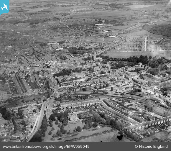
EPW059049 ENGLAND (1938). Old Town, Swindon, from the south, 1938
© Hawlfraint cyfranwyr OpenStreetMap a thrwyddedwyd gan yr OpenStreetMap Foundation. 2025. Trwyddedir y gartograffeg fel CC BY-SA.
Manylion
| Pennawd | [EPW059049] Old Town, Swindon, from the south, 1938 |
| Cyfeirnod | EPW059049 |
| Dyddiad | 30-August-1938 |
| Dolen | |
| Enw lle | SWINDON |
| Plwyf | |
| Ardal | |
| Gwlad | ENGLAND |
| Dwyreiniad / Gogleddiad | 415659, 183489 |
| Hydred / Lledred | -1.7741403846069, 51.549596310975 |
| Cyfeirnod Grid Cenedlaethol | SU157835 |
Pinnau
 Gary |
Friday 30th of August 2024 05:20:42 PM | |
 NottmJas |
Wednesday 26th of June 2024 12:17:36 PM | |
 Gary |
Tuesday 16th of January 2024 04:38:06 PM | |
 Gary |
Tuesday 16th of January 2024 04:32:23 PM | |
 Gary |
Tuesday 16th of January 2024 04:31:52 PM | |
 NottmJas |
Saturday 16th of September 2023 10:34:41 PM | |
 NottmJas |
Saturday 16th of September 2023 10:32:54 PM | |
 NottmJas |
Saturday 16th of September 2023 10:26:09 PM | |
 NottmJas |
Saturday 16th of September 2023 10:25:10 PM | |
 NottmJas |
Saturday 16th of September 2023 10:22:34 PM | |
 NottmJas |
Saturday 16th of September 2023 10:20:52 PM | |
 NottmJas |
Saturday 16th of September 2023 10:19:33 PM | |
 NottmJas |
Saturday 27th of June 2020 05:53:55 PM | |
 NottmJas |
Saturday 27th of June 2020 05:53:14 PM | |
 gBr |
Monday 11th of March 2019 09:42:24 PM | |
 gBr |
Monday 11th of March 2019 09:40:48 PM | |
 gBr |
Monday 11th of March 2019 09:39:26 PM | |
 gBr |
Friday 3rd of March 2017 02:24:10 PM | |
 gBr |
Friday 3rd of March 2017 02:22:32 PM | |
 gBr |
Friday 3rd of March 2017 02:11:43 PM | |
 gBr |
Friday 25th of September 2015 04:03:58 PM | |
 gBr |
Friday 25th of September 2015 04:01:45 PM | |
 gBr |
Friday 25th of September 2015 03:36:41 PM | |
 gBr |
Friday 25th of September 2015 03:28:55 PM | |
 Delboy |
Wednesday 6th of May 2015 08:18:01 AM | |
 Class31 |
Wednesday 4th of March 2015 09:14:06 AM | |
 S Hope |
Thursday 24th of July 2014 04:19:11 PM | |
 gerry-r |
Tuesday 3rd of June 2014 12:09:33 AM | |
 Class31 |
Tuesday 14th of January 2014 10:25:38 AM | |
 Class31 |
Tuesday 14th of January 2014 10:25:08 AM | |
 Class31 |
Tuesday 14th of January 2014 10:24:10 AM | |
 Class31 |
Tuesday 14th of January 2014 10:23:49 AM | |
 Class31 |
Tuesday 14th of January 2014 10:23:27 AM | |
For clarity the station here is the one in old town which closed in the late 50s or early 60s |
 S Hope |
Thursday 24th of July 2014 04:17:19 PM |
This is Swindon Old Town Railway station on the Midland and Southwest Junction Railway that went Andoversford at it's northern end and Andover in the south |
 Phil |
Monday 12th of October 2015 03:25:53 PM |
To clarify the clarification. Although located in the Old Town and known as such to Swindonians, the station was officially Swindon Town and the platform signs said as much. The pre-grouping company was the Midland & South Western Junction Railway (NOT South West), and so it was also referred to as the "Midland" station in earlier times. It closed to passengers in September 1961. |
 gBr |
Friday 3rd of March 2017 02:19:42 PM |
 kingcole |
Sunday 25th of August 2013 03:33:12 PM |


![[EPW059049] Old Town, Swindon, from the south, 1938](http://britainfromabove.org.uk/sites/all/libraries/aerofilms-images/public/100x100/EPW/059/EPW059049.jpg)
![[EPW010118] The station and High Street and environs, Swindon, 1924](http://britainfromabove.org.uk/sites/all/libraries/aerofilms-images/public/100x100/EPW/010/EPW010118.jpg)
![[EAW006874] Old Town and environs, Swindon, from the south, 1947](http://britainfromabove.org.uk/sites/all/libraries/aerofilms-images/public/100x100/EAW/006/EAW006874.jpg)
![[EPW010117] General view of Swindon from the High Street and environs, Swindon, 1924](http://britainfromabove.org.uk/sites/all/libraries/aerofilms-images/public/100x100/EPW/010/EPW010117.jpg)