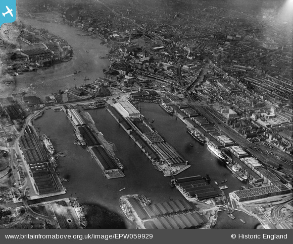
EPW059929 ENGLAND (1938). West India Docks and environs, Canary Wharf, 1938
© Hawlfraint cyfranwyr OpenStreetMap a thrwyddedwyd gan yr OpenStreetMap Foundation. 2025. Trwyddedir y gartograffeg fel CC BY-SA.
Delweddau cyfagos (8)
Manylion
| Pennawd | [EPW059929] West India Docks and environs, Canary Wharf, 1938 |
| Cyfeirnod | EPW059929 |
| Dyddiad | 15-October-1938 |
| Dolen | |
| Enw lle | CANARY WHARF |
| Plwyf | |
| Ardal | |
| Gwlad | ENGLAND |
| Dwyreiniad / Gogleddiad | 537383, 180385 |
| Hydred / Lledred | -0.020277839415223, 51.505193380216 |
| Cyfeirnod Grid Cenedlaethol | TQ374804 |
Pinnau
 Robin |
Saturday 7th of December 2024 08:07:27 PM | |
 Chaz |
Sunday 21st of January 2024 04:11:13 PM | |
 Class31 |
Saturday 15th of November 2014 09:06:01 AM | |
 Class31 |
Saturday 15th of November 2014 09:03:30 AM |
Cyfraniadau Grŵp
St. Anne's Church, Limehouse, Commercial Road, 30/09/2014 |
 Class31 |
Saturday 15th of November 2014 09:04:22 AM |


![[EPW059929] West India Docks and environs, Canary Wharf, 1938](http://britainfromabove.org.uk/sites/all/libraries/aerofilms-images/public/100x100/EPW/059/EPW059929.jpg)
![[EPW044129] West India Docks and the River Thames, Isle of Dogs, from the north-west, 1934](http://britainfromabove.org.uk/sites/all/libraries/aerofilms-images/public/100x100/EPW/044/EPW044129.jpg)
![[EPW044127] West India and Millwall Docks, Isle of Dogs, from the north, 1934. This image has been produced from a copy-negative.](http://britainfromabove.org.uk/sites/all/libraries/aerofilms-images/public/100x100/EPW/044/EPW044127.jpg)
![[EPW005993] West India Dock (Import), Canary Wharf, 1921](http://britainfromabove.org.uk/sites/all/libraries/aerofilms-images/public/100x100/EPW/005/EPW005993.jpg)
![[EPW045543] An infrared photograph showing the River Thames from Westminster Bridge to the sea, London, from the west, 1934](http://britainfromabove.org.uk/sites/all/libraries/aerofilms-images/public/100x100/EPW/045/EPW045543.jpg)
![[EPW059926] West India Docks and environs, Canary Wharf, 1938](http://britainfromabove.org.uk/sites/all/libraries/aerofilms-images/public/100x100/EPW/059/EPW059926.jpg)
![[EPW024258] West India Dock, Poplar, 1928](http://britainfromabove.org.uk/sites/all/libraries/aerofilms-images/public/100x100/EPW/024/EPW024258.jpg)
![[EPW059930] Limehouse and the River Thames at West India Docks, Canary Wharf, from the south-east, 1938](http://britainfromabove.org.uk/sites/all/libraries/aerofilms-images/public/100x100/EPW/059/EPW059930.jpg)