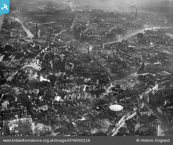
EPW060118 ENGLAND (1938). The city centre, Bristol, 1938
© Hawlfraint cyfranwyr OpenStreetMap a thrwyddedwyd gan yr OpenStreetMap Foundation. 2025. Trwyddedir y gartograffeg fel CC BY-SA.
Delweddau cyfagos (20)
Manylion
| Pennawd | [EPW060118] The city centre, Bristol, 1938 |
| Cyfeirnod | EPW060118 |
| Dyddiad | 1-November-1938 |
| Dolen | |
| Enw lle | BRISTOL |
| Plwyf | |
| Ardal | |
| Gwlad | ENGLAND |
| Dwyreiniad / Gogleddiad | 358820, 173155 |
| Hydred / Lledred | -2.5927436109175, 51.455386962516 |
| Cyfeirnod Grid Cenedlaethol | ST588732 |
Pinnau
 TarzeyMeese |
Wednesday 9th of December 2020 05:04:42 PM | |
 derek2847 |
Monday 5th of February 2018 03:02:10 AM | |
 derek2847 |
Monday 5th of February 2018 01:56:09 AM | |
 derek2847 |
Monday 5th of February 2018 01:47:37 AM | |
 derek2847 |
Monday 5th of February 2018 01:45:38 AM | |
 derek2847 |
Monday 5th of February 2018 01:42:23 AM | |
 derek2847 |
Monday 5th of February 2018 01:40:58 AM | |
 derek2847 |
Monday 5th of February 2018 01:38:09 AM | |
 derek2847 |
Monday 5th of February 2018 01:30:40 AM | |
 derek2847 |
Monday 5th of February 2018 01:19:58 AM | |
 derek2847 |
Monday 5th of February 2018 01:16:55 AM | |
 derek2847 |
Monday 5th of February 2018 01:03:15 AM | |
 derek2847 |
Monday 5th of February 2018 01:01:16 AM | |
 derek2847 |
Monday 5th of February 2018 12:50:18 AM | |
 derek2847 |
Sunday 4th of February 2018 08:10:40 PM | |
 MildBunch |
Wednesday 18th of February 2015 02:24:55 PM | |
 MildBunch |
Wednesday 18th of February 2015 02:24:13 PM | |
 Class31 |
Thursday 28th of November 2013 04:44:59 PM | |
 Class31 |
Thursday 28th of November 2013 04:42:24 PM | |
 Class31 |
Monday 30th of September 2013 07:19:44 PM | |
 Braikenridge |
Saturday 17th of August 2013 06:19:22 PM |


![[EPW060118] The city centre, Bristol, 1938](http://britainfromabove.org.uk/sites/all/libraries/aerofilms-images/public/100x100/EPW/060/EPW060118.jpg)
![[EPW022277] The city, Bristol, from the east, 1928](http://britainfromabove.org.uk/sites/all/libraries/aerofilms-images/public/100x100/EPW/022/EPW022277.jpg)
![[EPW005428] Rupert Street and environs, Bristol, 1921](http://britainfromabove.org.uk/sites/all/libraries/aerofilms-images/public/100x100/EPW/005/EPW005428.jpg)
![[EPW005427] Fry's Cocoa Manufactory on Union Street and environs, Bristol, 1921](http://britainfromabove.org.uk/sites/all/libraries/aerofilms-images/public/100x100/EPW/005/EPW005427.jpg)
![[EPW005431] Rupert Street and environs, Bristol, 1921](http://britainfromabove.org.uk/sites/all/libraries/aerofilms-images/public/100x100/EPW/005/EPW005431.jpg)
![[EPW005429] Quay Street and environs, Bristol, 1921](http://britainfromabove.org.uk/sites/all/libraries/aerofilms-images/public/100x100/EPW/005/EPW005429.jpg)
![[EPW005423] Fry's Cocoa Manufactory on Union Street and environs, Bristol, 1921](http://britainfromabove.org.uk/sites/all/libraries/aerofilms-images/public/100x100/EPW/005/EPW005423.jpg)
![[EPW005432] Quay Street and environs, Bristol, 1921](http://britainfromabove.org.uk/sites/all/libraries/aerofilms-images/public/100x100/EPW/005/EPW005432.jpg)
![[EPW005426] Fry's Cocoa Manufactory on Union Street and environs, Bristol, 1921](http://britainfromabove.org.uk/sites/all/libraries/aerofilms-images/public/100x100/EPW/005/EPW005426.jpg)
![[EPW005430] Rupert Street and environs, Bristol, 1921](http://britainfromabove.org.uk/sites/all/libraries/aerofilms-images/public/100x100/EPW/005/EPW005430.jpg)
![[EPW005419] Lewins Mead and environs, Bristol, 1921](http://britainfromabove.org.uk/sites/all/libraries/aerofilms-images/public/100x100/EPW/005/EPW005419.jpg)
![[EPW005425] Fry's Cocoa Manufactory on Union Street and environs, Bristol, 1921](http://britainfromabove.org.uk/sites/all/libraries/aerofilms-images/public/100x100/EPW/005/EPW005425.jpg)
![[EPW005424] Fry's Cocoa Manufactory on Union Street and environs, Bristol, 1921](http://britainfromabove.org.uk/sites/all/libraries/aerofilms-images/public/100x100/EPW/005/EPW005424.jpg)
![[EPW005421] Fry's Cocoa Manufactory on Union Street and environs, Bristol, 1921](http://britainfromabove.org.uk/sites/all/libraries/aerofilms-images/public/100x100/EPW/005/EPW005421.jpg)
![[EPW047090] Colston Avenue and the city centre, Bristol, 1935](http://britainfromabove.org.uk/sites/all/libraries/aerofilms-images/public/100x100/EPW/047/EPW047090.jpg)
![[EPW005420] Fry's Cocoa Manufactory on Union Street and environs, Bristol, 1921](http://britainfromabove.org.uk/sites/all/libraries/aerofilms-images/public/100x100/EPW/005/EPW005420.jpg)
![[EPW033500] St James' Park and the city, Bristol, from the south-west, 1930](http://britainfromabove.org.uk/sites/all/libraries/aerofilms-images/public/100x100/EPW/033/EPW033500.jpg)
![[EPW005422] Fry's Cocoa Manufactory on Union Street and environs, Bristol, 1921](http://britainfromabove.org.uk/sites/all/libraries/aerofilms-images/public/100x100/EPW/005/EPW005422.jpg)
![[EAW050555] Baldwin Street and environs, Bristol, 1953](http://britainfromabove.org.uk/sites/all/libraries/aerofilms-images/public/100x100/EAW/050/EAW050555.jpg)
![[EPW033498] Bristol Bridge and the city, Bristol, 1930](http://britainfromabove.org.uk/sites/all/libraries/aerofilms-images/public/100x100/EPW/033/EPW033498.jpg)