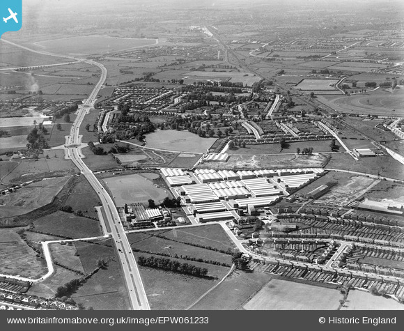
EPW061233 ENGLAND (1939). The Industrial Estate on Western Avenue, Greenford, from the south-east, 1939
© Hawlfraint cyfranwyr OpenStreetMap a thrwyddedwyd gan yr OpenStreetMap Foundation. 2025. Trwyddedir y gartograffeg fel CC BY-SA.
Delweddau cyfagos (23)
Manylion
| Pennawd | [EPW061233] The Industrial Estate on Western Avenue, Greenford, from the south-east, 1939 |
| Cyfeirnod | EPW061233 |
| Dyddiad | 26-May-1939 |
| Dolen | |
| Enw lle | GREENFORD |
| Plwyf | |
| Ardal | |
| Gwlad | ENGLAND |
| Dwyreiniad / Gogleddiad | 513913, 183612 |
| Hydred / Lledred | -0.35727778304597, 51.539419755634 |
| Cyfeirnod Grid Cenedlaethol | TQ139836 |
Pinnau
 j miller |
Sunday 8th of November 2020 03:45:59 PM | |
 j miller |
Sunday 8th of November 2020 03:42:53 PM | |
 j miller |
Sunday 8th of November 2020 03:40:40 PM | |
 j miller |
Sunday 8th of November 2020 03:38:58 PM | |
 j miller |
Sunday 8th of November 2020 03:34:14 PM | |
 j miller |
Sunday 8th of November 2020 03:31:26 PM | |
 David Posnett |
Monday 12th of October 2020 06:30:05 PM | |
 KNITBY |
Tuesday 18th of June 2019 10:08:29 PM | |
 Des Elmes |
Tuesday 5th of April 2016 02:52:18 AM | |
 Des Elmes |
Tuesday 5th of April 2016 02:51:35 AM | |
 Des Elmes |
Tuesday 5th of April 2016 02:50:52 AM | |
 Des Elmes |
Tuesday 5th of April 2016 02:49:27 AM | |
 Des Elmes |
Tuesday 5th of April 2016 02:48:31 AM | |
 Des Elmes |
Tuesday 5th of April 2016 02:46:50 AM | |
 The Laird |
Wednesday 29th of April 2015 03:12:04 PM | |
 The Laird |
Wednesday 29th of April 2015 03:06:14 PM | |
 The Laird |
Wednesday 29th of April 2015 03:04:38 PM | |
 The Laird |
Wednesday 29th of April 2015 03:02:26 PM | |
 The Laird |
Wednesday 29th of April 2015 03:00:27 PM | |
 The Laird |
Wednesday 29th of April 2015 02:59:37 PM | |
 David Posnett |
Monday 29th of December 2014 01:54:58 PM | |
 David Posnett |
Monday 29th of December 2014 01:54:54 PM | |
 Martyn |
Saturday 23rd of November 2013 02:19:45 PM | |
 SimonRoberts |
Friday 1st of November 2013 11:03:50 AM | |
 SimonRoberts |
Friday 1st of November 2013 11:02:52 AM | |
 SimonRoberts |
Friday 1st of November 2013 11:02:21 AM |
Cyfraniadau Grŵp
another view from Belvue School |
 SimonRoberts |
Friday 1st of November 2013 01:37:56 PM |
A view from Belvue School |
 SimonRoberts |
Friday 1st of November 2013 11:06:39 AM |


![[EPW061233] The Industrial Estate on Western Avenue, Greenford, from the south-east, 1939](http://britainfromabove.org.uk/sites/all/libraries/aerofilms-images/public/100x100/EPW/061/EPW061233.jpg)
![[EPW059347] The Aladdin Building (Lamp Shade Manufactory), Greenford, 1938](http://britainfromabove.org.uk/sites/all/libraries/aerofilms-images/public/100x100/EPW/059/EPW059347.jpg)
![[EPW059346] The Aladdin Building (Lamp Shade Manufactory) and environs, Greenford, 1938](http://britainfromabove.org.uk/sites/all/libraries/aerofilms-images/public/100x100/EPW/059/EPW059346.jpg)
![[EPW053625] The Aladdin Building, Greenford, 1937](http://britainfromabove.org.uk/sites/all/libraries/aerofilms-images/public/100x100/EPW/053/EPW053625.jpg)
![[EPW053624] The Aladdin Building, Greenford, 1937](http://britainfromabove.org.uk/sites/all/libraries/aerofilms-images/public/100x100/EPW/053/EPW053624.jpg)
![[EPW053623] The Aladdin Building, Greenford, 1937](http://britainfromabove.org.uk/sites/all/libraries/aerofilms-images/public/100x100/EPW/053/EPW053623.jpg)
![[EPW053617] The Aladdin Building, Greenford, 1937](http://britainfromabove.org.uk/sites/all/libraries/aerofilms-images/public/100x100/EPW/053/EPW053617.jpg)
![[EPW038793] The Aladdin Building (Lamp Shade Manufactory), Greenford, 1932](http://britainfromabove.org.uk/sites/all/libraries/aerofilms-images/public/100x100/EPW/038/EPW038793.jpg)
![[EPW038797] The Aladdin Building (Lamp Shade Manufactory), Greenford, 1932](http://britainfromabove.org.uk/sites/all/libraries/aerofilms-images/public/100x100/EPW/038/EPW038797.jpg)
![[EPW053622] The Aladdin Building, Greenford, 1937](http://britainfromabove.org.uk/sites/all/libraries/aerofilms-images/public/100x100/EPW/053/EPW053622.jpg)
![[EPW053620] The Aladdin Building, Greenford, from the south-west, 1937](http://britainfromabove.org.uk/sites/all/libraries/aerofilms-images/public/100x100/EPW/053/EPW053620.jpg)
![[EPW053621] The Aladdin Building, Greenford, from the south-west, 1937](http://britainfromabove.org.uk/sites/all/libraries/aerofilms-images/public/100x100/EPW/053/EPW053621.jpg)
![[EPW038796] The Aladdin Building (Lamp Shade Manufactory), Greenford, 1932](http://britainfromabove.org.uk/sites/all/libraries/aerofilms-images/public/100x100/EPW/038/EPW038796.jpg)
![[EPW053619] The Aladdin Building, Greenford, from the south-west, 1937](http://britainfromabove.org.uk/sites/all/libraries/aerofilms-images/public/100x100/EPW/053/EPW053619.jpg)
![[EPW038795] The Aladdin Building (Lamp Shade Manufactory), Greenford, 1932](http://britainfromabove.org.uk/sites/all/libraries/aerofilms-images/public/100x100/EPW/038/EPW038795.jpg)
![[EPW038794] The Aladdin Building (Lamp Shade Manufactory) and Greenford Trotting Track, Greenford, 1932](http://britainfromabove.org.uk/sites/all/libraries/aerofilms-images/public/100x100/EPW/038/EPW038794.jpg)
![[EPW038798] The Aladdin Building (Lamp Shade Manufactory) and Greenford Trotting Track, Greenford, 1932](http://britainfromabove.org.uk/sites/all/libraries/aerofilms-images/public/100x100/EPW/038/EPW038798.jpg)
![[EPW053618] The Aladdin Building, Greenford, from the south-west, 1937](http://britainfromabove.org.uk/sites/all/libraries/aerofilms-images/public/100x100/EPW/053/EPW053618.jpg)
![[EPR000604] The Aladdin Building (Lamp Shade Manufactory), Greenford, 1935](http://britainfromabove.org.uk/sites/all/libraries/aerofilms-images/public/100x100/EPR/000/EPR000604.jpg)
![[EPW034573] The British Bath Co. Ltd Works, construction of the Aladdin Building and the Greenford Trotting Track, Greenford, 1930](http://britainfromabove.org.uk/sites/all/libraries/aerofilms-images/public/100x100/EPW/034/EPW034573.jpg)
![[EPR000028] Western Avenue under construction alongside the Aladdin Building and the surrounding area, Greenford, from the north-west, 1934](http://britainfromabove.org.uk/sites/all/libraries/aerofilms-images/public/100x100/EPR/000/EPR000028.jpg)
![[EPR000029] Western Avenue under construction alongside the Aladdin Building and the Grand Union Canal (Paddington Branch), Greenford, 1934](http://britainfromabove.org.uk/sites/all/libraries/aerofilms-images/public/100x100/EPR/000/EPR000029.jpg)
![[EPW023425] The Greenford Trotting Track and The British Bath Company Manufactory, Greenford, 1928](http://britainfromabove.org.uk/sites/all/libraries/aerofilms-images/public/100x100/EPW/023/EPW023425.jpg)