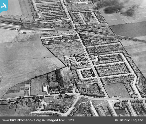
EPW062233 ENGLAND (1939). New North Road and environs, Fairlop, 1939
© Hawlfraint cyfranwyr OpenStreetMap a thrwyddedwyd gan yr OpenStreetMap Foundation. 2025. Trwyddedir y gartograffeg fel CC BY-SA.
Delweddau cyfagos (5)
Manylion
| Pennawd | [EPW062233] New North Road and environs, Fairlop, 1939 |
| Cyfeirnod | EPW062233 |
| Dyddiad | 25-July-1939 |
| Dolen | |
| Enw lle | FAIRLOP |
| Plwyf | |
| Ardal | |
| Gwlad | ENGLAND |
| Dwyreiniad / Gogleddiad | 544747, 191505 |
| Hydred / Lledred | 0.090342705859491, 51.603284312245 |
| Cyfeirnod Grid Cenedlaethol | TQ447915 |
Pinnau
 Jenny Karling |
Friday 29th of May 2015 06:47:24 PM | |
 Jenny Karling |
Friday 29th of May 2015 06:41:46 PM | |
 Jenny Karling |
Friday 29th of May 2015 06:40:11 PM | |
 Jenny Karling |
Saturday 16th of November 2013 11:54:19 AM | |
 Jenny Karling |
Saturday 19th of October 2013 11:55:30 AM | |
 Maurice |
Thursday 5th of September 2013 10:54:09 PM | |
 Maurice |
Thursday 5th of September 2013 10:52:48 PM | |
 Maurice |
Thursday 5th of September 2013 10:51:27 PM | |
 Maurice |
Thursday 5th of September 2013 10:50:26 PM | |
 Maurice |
Thursday 5th of September 2013 10:49:31 PM | |
 Jenny Karling |
Thursday 5th of September 2013 08:20:45 PM | |
 Jenny Karling |
Thursday 5th of September 2013 08:18:59 PM | |
 Jenny Karling |
Thursday 5th of September 2013 08:16:33 PM | |
 Jenny Karling |
Thursday 5th of September 2013 08:15:30 PM | |
 Jenny Karling |
Thursday 5th of September 2013 08:14:55 PM | |
 Jenny Karling |
Thursday 5th of September 2013 08:08:17 PM | |
 Jenny Karling |
Thursday 5th of September 2013 07:25:12 PM |


![[EPW062233] New North Road and environs, Fairlop, 1939](http://britainfromabove.org.uk/sites/all/libraries/aerofilms-images/public/100x100/EPW/062/EPW062233.jpg)
![[EPW062241] Henry Hughes and Son Husun Nautical Instrument Works, Fairlop, 1939](http://britainfromabove.org.uk/sites/all/libraries/aerofilms-images/public/100x100/EPW/062/EPW062241.jpg)
![[EPW062234] Henry Hughes and Son Husun Nautical Instrument Works, Fairlop, 1939](http://britainfromabove.org.uk/sites/all/libraries/aerofilms-images/public/100x100/EPW/062/EPW062234.jpg)
![[EPW062242] Henry Hughes and Son Husun Nautical Instrument Works, Fairlop, 1939](http://britainfromabove.org.uk/sites/all/libraries/aerofilms-images/public/100x100/EPW/062/EPW062242.jpg)
![[EPW062232] New North Road and environs, Fairlop, 1939](http://britainfromabove.org.uk/sites/all/libraries/aerofilms-images/public/100x100/EPW/062/EPW062232.jpg)