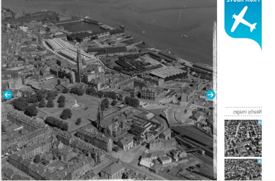
SAR018766 SCOTLAND (1953). General View Greenock, Renfrewshire, Scotland. An oblique aerial photograph taken facing North/East. This image was marked by AeroPictorial Ltd for photo editing.
© Hawlfraint cyfranwyr OpenStreetMap a thrwyddedwyd gan yr OpenStreetMap Foundation. 2025. Trwyddedir y gartograffeg fel CC BY-SA.
Delweddau cyfagos (11)
Manylion
| Pennawd | [SAR018766] General View Greenock, Renfrewshire, Scotland. An oblique aerial photograph taken facing North/East. This image was marked by AeroPictorial Ltd for photo editing. |
| Cyfeirnod | SAR018766 |
| Dyddiad | 1953 |
| Dolen | Canmore Collection item 1438081 |
| Enw lle | |
| Plwyf | GREENOCK |
| Ardal | INVERCLYDE |
| Gwlad | SCOTLAND |
| Dwyreiniad / Gogleddiad | 227610, 676260 |
| Hydred / Lledred | -4.761077377206, 55.948435423517 |
| Cyfeirnod Grid Cenedlaethol | NS276763 |
Pinnau
Cyfraniadau Grŵp
 This photo is round the wrong way...would be good if it could be fixed |
 angela |
Monday 6th of October 2014 04:07:35 PM |
This image is the wrong way around |
 Elliott |
Monday 6th of October 2014 04:03:59 PM |
Yes i agree. |
 Tommy |
Monday 6th of October 2014 04:03:59 PM |
 This image is the wrong way round ie: it is a mirrored version I have attached a corrected version. |
 Tommy |
Monday 6th of October 2014 04:02:12 PM |


![[SAR018766] General View Greenock, Renfrewshire, Scotland. An oblique aerial photograph taken facing North/East. This image was marked by AeroPictorial Ltd for photo editing.](http://britainfromabove.org.uk/sites/all/libraries/aerofilms-images/public/100x100/SAR/018/SAR018766.jpg)
![[SAW032142] Greenock, general view, showing John Hastie and Co. Ltd. Kilblain Street Engine Works and Albert Harbour. An oblique aerial photograph taken facing north-east. This image has been produced from a crop marked negative.](http://britainfromabove.org.uk/sites/all/libraries/aerofilms-images/public/100x100/SAW/032/SAW032142.jpg)
![[SAW032143] Greenock, general view, showing John Hastie and Co. Ltd. Kilblain Street Engine Works and St George's North Church, George Square. An oblique aerial photograph taken facing south. This image has been produced from a crop marked negative.](http://britainfromabove.org.uk/sites/all/libraries/aerofilms-images/public/100x100/SAW/032/SAW032143.jpg)
![[SAW032146] Greenock, general view, showing John Hastie and Co. Ltd. Kilblain Street Engine Works and Nelson Street. An oblique aerial photograph taken facing east. This image has been produced from a crop marked negative.](http://britainfromabove.org.uk/sites/all/libraries/aerofilms-images/public/100x100/SAW/032/SAW032146.jpg)
![[SAW009823] Greenock, general view, showing Nelson Street and Inverkip Street. An oblique aerial photograph taken facing west.](http://britainfromabove.org.uk/sites/all/libraries/aerofilms-images/public/100x100/SAW/009/SAW009823.jpg)
![[SAW032139] Greenock, general view, showing John Hastie and Co. Ltd. Kilblain Street Engine Works and Court House, Nelson Street. An oblique aerial photograph taken facing south-east.](http://britainfromabove.org.uk/sites/all/libraries/aerofilms-images/public/100x100/SAW/032/SAW032139.jpg)
![[SAW032141] Greenock, general view, showing John Hastie and Co. Ltd. Kilblain Street Engine Works and St George's North Church, George Square. An oblique aerial photograph taken facing south. This image has been produced from a crop marked negative.](http://britainfromabove.org.uk/sites/all/libraries/aerofilms-images/public/100x100/SAW/032/SAW032141.jpg)
![[SAW032144] Greenock, general view, showing John Hastie and Co. Ltd. Kilblain Street Engine Works and Union Street. An oblique aerial photograph taken facing north-west.](http://britainfromabove.org.uk/sites/all/libraries/aerofilms-images/public/100x100/SAW/032/SAW032144.jpg)
![[SAW032145] Greenock, general view, showing John Hastie and Co. Ltd. Kilblain Street Engine Works and Old Kirk, Nelson Street. An oblique aerial photograph taken facing east. This image has been produced from a crop marked negative.](http://britainfromabove.org.uk/sites/all/libraries/aerofilms-images/public/100x100/SAW/032/SAW032145.jpg)
![[SAW009810] Greenock, general view, showing Dalrymple Street and Well Park. An oblique aerial photograph taken facing south.](http://britainfromabove.org.uk/sites/all/libraries/aerofilms-images/public/100x100/SAW/009/SAW009810.jpg)
![[SAW032140] Greenock, general view, showing John Hastie and Co. Ltd. Kilblain Street Engine Works and Union Street. An oblique aerial photograph taken facing north-west. This image has been produced from a crop marked negative.](http://britainfromabove.org.uk/sites/all/libraries/aerofilms-images/public/100x100/SAW/032/SAW032140.jpg)