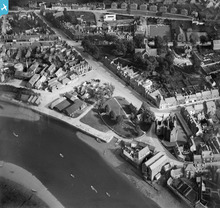
SPW034426 SCOTLAND (1930). Kirkcudbright, general view, showing St Cuthbert Street and MacLellan's Castle. An oblique aerial photograph taken facing south-east.
© Hawlfraint cyfranwyr OpenStreetMap a thrwyddedwyd gan yr OpenStreetMap Foundation. 2025. Trwyddedir y gartograffeg fel CC BY-SA.
Delweddau cyfagos (5)
Manylion
| Pennawd | [SPW034426] Kirkcudbright, general view, showing St Cuthbert Street and MacLellan's Castle. An oblique aerial photograph taken facing south-east. |
| Cyfeirnod | SPW034426 |
| Dyddiad | 1930 |
| Dolen | Canmore Collection item 1257154 |
| Enw lle | |
| Plwyf | KIRKCUDBRIGHT |
| Ardal | STEWARTRY |
| Gwlad | SCOTLAND |
| Dwyreiniad / Gogleddiad | 268310, 551090 |
| Hydred / Lledred | -4.0507202599159, 54.837197802766 |
| Cyfeirnod Grid Cenedlaethol | NX683511 |
Pinnau
Byddwch y cyntaf i ychwanegu sylw at y ddelwedd hon!
Cyfraniadau Grŵp
 Borders Project |
Tuesday 5th of August 2014 04:34:40 PM | |
One of 18 images to be discussed at drop in workshops at the Kirkcudbright Parish Church Hall on Wednesday, 6th August, Thursday 7th August and Friday 8th August between 2.00-5.00pm. Working with the Kirkcudbright History Society, the organisers of the Britain from Above - Borders project are hoping to hear reminiscences, memories and insights about aspects of the town which are so clear in the photographs and yet may be now changed or gone. The accounts inspired by the photographs will be noted and compiled into a booklet. The enlarged pictures show both the whole town from several hundred feet as well as more detailed views taken at lower level such as the adjacent photograph of the Harbour Square in 1947, when the fair was in town. There are also views of the Gibb Hill Air Sea Rescue base in 1947, and earlier views of the St. Mary Street / High Street area taken in the 1930s. |
 Borders Project |
Tuesday 29th of July 2014 03:09:30 PM |


![[SPW034424] Kirkcudbright, general view, showing Kirkcudbright Bridge, St Mary Street and MacLellan's Castle. An oblique aerial photograph taken facing north-east.](http://britainfromabove.org.uk/sites/all/libraries/aerofilms-images/public/100x100/SPW/034/SPW034424.jpg)
![[SPW034426] Kirkcudbright, general view, showing St Cuthbert Street and MacLellan's Castle. An oblique aerial photograph taken facing south-east.](http://britainfromabove.org.uk/sites/all/libraries/aerofilms-images/public/100x100/SPW/034/SPW034426.jpg)
![[SPW034428] Kirkcudbright, general view, showing Kirkcudbright Bridge and Parish Church, St Mary Street. An oblique aerial photograph taken facing south-east.](http://britainfromabove.org.uk/sites/all/libraries/aerofilms-images/public/100x100/SPW/034/SPW034428.jpg)
![[SPW034425] Kirkcudbright, general view, showing High Street and MacLellan's Castle. An oblique aerial photograph taken facing north-east.](http://britainfromabove.org.uk/sites/all/libraries/aerofilms-images/public/100x100/SPW/034/SPW034425.jpg)
![[SPW034427] Kirkcudbright, general view, showing Kilndale Terrace and St Mary Street. An oblique aerial photograph taken facing south.](http://britainfromabove.org.uk/sites/all/libraries/aerofilms-images/public/100x100/SPW/034/SPW034427.jpg)
