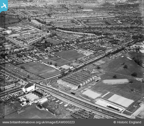
EAW000223 ENGLAND (1946). The Standard Motor Company works on Fletchampstead Highway and environs, Coventry, 1946
© Copyright OpenStreetMap contributors and licensed by the OpenStreetMap Foundation. 2024. Cartography is licensed as CC BY-SA.
Nearby Images (12)
Details
| Title | [EAW000223] The Standard Motor Company works on Fletchampstead Highway and environs, Coventry, 1946 |
| Reference | EAW000223 |
| Date | 15-April-1946 |
| Link | |
| Place name | COVENTRY |
| Parish | |
| District | |
| Country | ENGLAND |
| Easting / Northing | 430348, 278592 |
| Longitude / Latitude | -1.5538629095243, 52.404116758877 |
| National Grid Reference | SP303786 |
Pins
 redmist |
Wednesday 7th of October 2020 10:04:57 PM | |
 redmist |
Wednesday 7th of October 2020 10:03:55 PM | |
 redmist |
Wednesday 7th of October 2020 10:03:10 PM | |
 redmist |
Wednesday 7th of October 2020 10:01:45 PM | |
 Sparky |
Thursday 31st of August 2017 09:58:26 PM | |
 JG |
Wednesday 20th of January 2016 07:36:24 PM | |
 JG |
Saturday 8th of February 2014 02:07:12 PM |


![[EAW000223] The Standard Motor Company works on Fletchampstead Highway and environs, Coventry, 1946](http://britainfromabove.org.uk/sites/all/libraries/aerofilms-images/public/100x100/EAW/000/EAW000223.jpg)
![[EAW000224] The Standard Motor Company works on Fletchampstead Highway and environs, Coventry, 1946](http://britainfromabove.org.uk/sites/all/libraries/aerofilms-images/public/100x100/EAW/000/EAW000224.jpg)
![[EAW000222] The Standard Motor Company works on Fletchampstead Highway and environs, Coventry, 1946](http://britainfromabove.org.uk/sites/all/libraries/aerofilms-images/public/100x100/EAW/000/EAW000222.jpg)
![[EAW000219] The Standard Motor Company works on Fletchampstead Highway, Coventry, 1946](http://britainfromabove.org.uk/sites/all/libraries/aerofilms-images/public/100x100/EAW/000/EAW000219.jpg)
![[EAW000221] The Standard Motor Company works on Fletchampstead Highway, Coventry, 1946](http://britainfromabove.org.uk/sites/all/libraries/aerofilms-images/public/100x100/EAW/000/EAW000221.jpg)
![[EAW000220] The Standard Motor Company works on Fletchampstead Highway, Coventry, 1946](http://britainfromabove.org.uk/sites/all/libraries/aerofilms-images/public/100x100/EAW/000/EAW000220.jpg)
![[EPW053121] The Standard Motor Works, Coventry, 1937](http://britainfromabove.org.uk/sites/all/libraries/aerofilms-images/public/100x100/EPW/053/EPW053121.jpg)
![[EPW053122] The Standard Motor Works, Coventry, 1937](http://britainfromabove.org.uk/sites/all/libraries/aerofilms-images/public/100x100/EPW/053/EPW053122.jpg)
![[EPW053124] The Standard Motor Works, Coventry, 1937](http://britainfromabove.org.uk/sites/all/libraries/aerofilms-images/public/100x100/EPW/053/EPW053124.jpg)
![[EAW000147] Standard Motor Co Motor Car Service Station at the junction of Fletchamstead Highway and Tile Hill Lane, Coventry, 1946](http://britainfromabove.org.uk/sites/all/libraries/aerofilms-images/public/100x100/EAW/000/EAW000147.jpg)
![[EPW053119] The Standard Motor Works, Coventry, 1937](http://britainfromabove.org.uk/sites/all/libraries/aerofilms-images/public/100x100/EPW/053/EPW053119.jpg)
![[EPW053123] The Standard Motor Works, Coventry, from the north-west, 1937](http://britainfromabove.org.uk/sites/all/libraries/aerofilms-images/public/100x100/EPW/053/EPW053123.jpg)