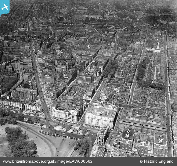
EAW000562 ENGLAND (1946). Marble Arch, Great Cumberland Place and the Edgware Road, Marylebone, from the south-east, 1946
© Copyright OpenStreetMap contributors and licensed by the OpenStreetMap Foundation. 2025. Cartography is licensed as CC BY-SA.
Nearby Images (38)
Details
| Title | [EAW000562] Marble Arch, Great Cumberland Place and the Edgware Road, Marylebone, from the south-east, 1946 |
| Reference | EAW000562 |
| Date | 9-May-1946 |
| Link | |
| Place name | MARYLEBONE |
| Parish | |
| District | |
| Country | ENGLAND |
| Easting / Northing | 527848, 181018 |
| Longitude / Latitude | -0.15737065547633, 51.51312065656 |
| National Grid Reference | TQ278810 |
Pins
 Class31 |
Wednesday 11th of March 2015 03:31:44 PM | |
 Class31 |
Wednesday 11th of March 2015 09:00:53 AM | |
 Class31 |
Thursday 31st of July 2014 06:04:19 PM | |
 Alan McFaden |
Thursday 14th of November 2013 05:50:36 PM | |
 Alan McFaden |
Thursday 14th of November 2013 05:49:59 PM |


![[EAW000562] Marble Arch, Great Cumberland Place and the Edgware Road, Marylebone, from the south-east, 1946](http://britainfromabove.org.uk/sites/all/libraries/aerofilms-images/public/100x100/EAW/000/EAW000562.jpg)
![[EPW044580] Marble Arch, the Cumberland Hotel and surroundings, Hyde Park, 1934](http://britainfromabove.org.uk/sites/all/libraries/aerofilms-images/public/100x100/EPW/044/EPW044580.jpg)
![[EAW046366] Marble Arch, Speakers' Corner and Oxford Street, Marylebone, 1952](http://britainfromabove.org.uk/sites/all/libraries/aerofilms-images/public/100x100/EAW/046/EAW046366.jpg)
![[EAW050846] Marble Arch, the Odeon Cinema, Cumberland Hotel and environs, Westminster, 1953](http://britainfromabove.org.uk/sites/all/libraries/aerofilms-images/public/100x100/EAW/050/EAW050846.jpg)
![[EAW050847] Marble Arch, the Odeon Cinema, Cumberland Hotel and environs, Westminster, 1953](http://britainfromabove.org.uk/sites/all/libraries/aerofilms-images/public/100x100/EAW/050/EAW050847.jpg)
![[EPW044582] Marble Arch, the Cumberland Hotel and the Maison Lyons, Hyde Park, 1934](http://britainfromabove.org.uk/sites/all/libraries/aerofilms-images/public/100x100/EPW/044/EPW044582.jpg)
![[EPW044579] Marble Arch, the Cumberland Hotel and surroundings, Hyde Park, 1934](http://britainfromabove.org.uk/sites/all/libraries/aerofilms-images/public/100x100/EPW/044/EPW044579.jpg)
![[EPW005989] Marble Arch, Hyde Park, 1921](http://britainfromabove.org.uk/sites/all/libraries/aerofilms-images/public/100x100/EPW/005/EPW005989.jpg)
![[EPW059408] Speakers' Corner and Marble Arch, Westminster, 1938](http://britainfromabove.org.uk/sites/all/libraries/aerofilms-images/public/100x100/EPW/059/EPW059408.jpg)
![[EAW053006] Speakers' Corner, Marble Arch and environs, Westminster, 1953](http://britainfromabove.org.uk/sites/all/libraries/aerofilms-images/public/100x100/EAW/053/EAW053006.jpg)
![[EPW005906] Marble Arch, Oxford Street and environs, Hyde Park, 1921. This image has been produced from a copy-negative.](http://britainfromabove.org.uk/sites/all/libraries/aerofilms-images/public/100x100/EPW/005/EPW005906.jpg)
![[EPW060763] Speakers' Corner and Oxford Street, Hyde Park, 1939](http://britainfromabove.org.uk/sites/all/libraries/aerofilms-images/public/100x100/EPW/060/EPW060763.jpg)
![[EPW007997] Hyde Park, the homecoming parade of the Prince of Wales, 1922](http://britainfromabove.org.uk/sites/all/libraries/aerofilms-images/public/100x100/EPW/007/EPW007997.jpg)
![[EPW007999] Hyde Park, the homecoming parade of the Prince of Wales, 1922](http://britainfromabove.org.uk/sites/all/libraries/aerofilms-images/public/100x100/EPW/007/EPW007999.jpg)
![[EPW035003] Speakers' Corner, Marble Arch and environs, Hyde Park, 1931](http://britainfromabove.org.uk/sites/all/libraries/aerofilms-images/public/100x100/EPW/035/EPW035003.jpg)
![[EAW000567] Marble Arch and environs, Marylebone, 1946](http://britainfromabove.org.uk/sites/all/libraries/aerofilms-images/public/100x100/EAW/000/EAW000567.jpg)
![[EPW007998] Hyde Park, the homecoming parade of the Prince of Wales, 1922](http://britainfromabove.org.uk/sites/all/libraries/aerofilms-images/public/100x100/EPW/007/EPW007998.jpg)
![[EAW050852] Marble Arch, Hereford House and environs, Westminster, 1953](http://britainfromabove.org.uk/sites/all/libraries/aerofilms-images/public/100x100/EAW/050/EAW050852.jpg)
![[EPW059414] Hyde Park, Speakers' Corner and surroundings, Westminster, 1938](http://britainfromabove.org.uk/sites/all/libraries/aerofilms-images/public/100x100/EPW/059/EPW059414.jpg)
![[EAW000545] Marble Arch, Oxford Street and environs, Westminster, 1946](http://britainfromabove.org.uk/sites/all/libraries/aerofilms-images/public/100x100/EAW/000/EAW000545.jpg)
![[EPW035004] Speakers' Corner, Marble Arch and environs, Hyde Park, 1931](http://britainfromabove.org.uk/sites/all/libraries/aerofilms-images/public/100x100/EPW/035/EPW035004.jpg)
![[EAW050845] Marble Arch, the Cumberland and Mount Royal Hotels and environs, Westminster, 1953](http://britainfromabove.org.uk/sites/all/libraries/aerofilms-images/public/100x100/EAW/050/EAW050845.jpg)
![[EAW050870] Oxford Street, the Cumberland and Mount Royal Hotels and Portman Square, Westminster, 1953](http://britainfromabove.org.uk/sites/all/libraries/aerofilms-images/public/100x100/EAW/050/EAW050870.jpg)
![[EAW000566] Marble Arch, Cumberland Place and environs, Marylebone, 1946](http://britainfromabove.org.uk/sites/all/libraries/aerofilms-images/public/100x100/EAW/000/EAW000566.jpg)
![[EPW006158] Marble Arch on Speakers' Corner, Hyde Park, London, from the north-east, 1921](http://britainfromabove.org.uk/sites/all/libraries/aerofilms-images/public/100x100/EPW/006/EPW006158.jpg)
![[EPW059413] Speakers' Corner, Marble Arch and surroundings, Westminster, 1938](http://britainfromabove.org.uk/sites/all/libraries/aerofilms-images/public/100x100/EPW/059/EPW059413.jpg)
![[EPW055350] Speaker's Corner, Portman Square and environs, Marylebone, 1937](http://britainfromabove.org.uk/sites/all/libraries/aerofilms-images/public/100x100/EPW/055/EPW055350.jpg)
![[EAW029834] Marble Arch and Oxford Street, Mayfair, from the west, 1950](http://britainfromabove.org.uk/sites/all/libraries/aerofilms-images/public/100x100/EAW/029/EAW029834.jpg)
![[EAW052481] Oxford Street east of Marble Arch, Westminster, 1953](http://britainfromabove.org.uk/sites/all/libraries/aerofilms-images/public/100x100/EAW/052/EAW052481.jpg)
![[EPW059409] Marble Arch and Edgware Road, Westminster, 1938](http://britainfromabove.org.uk/sites/all/libraries/aerofilms-images/public/100x100/EPW/059/EPW059409.jpg)
![[EPW011416] Oxford Street and environs, Westminster, 1924](http://britainfromabove.org.uk/sites/all/libraries/aerofilms-images/public/100x100/EPW/011/EPW011416.jpg)
![[EPW021405] Oxford Street and environs, Mayfair, from the west, 1928](http://britainfromabove.org.uk/sites/all/libraries/aerofilms-images/public/100x100/EPW/021/EPW021405.jpg)
![[EPW021436] Oxford Street and environs, Marylebone, from the west, 1928](http://britainfromabove.org.uk/sites/all/libraries/aerofilms-images/public/100x100/EPW/021/EPW021436.jpg)
![[EAW000564] Gloucester Place, Baker Street and environs, Marylebone, 1946](http://britainfromabove.org.uk/sites/all/libraries/aerofilms-images/public/100x100/EAW/000/EAW000564.jpg)
![[EPR000431] Oxford Street between Park Lane and Selfridges, Westminster, 1934](http://britainfromabove.org.uk/sites/all/libraries/aerofilms-images/public/100x100/EPR/000/EPR000431.jpg)
![[EAW030118] Oxford Street and the city, Mayfair, from the west, 1950](http://britainfromabove.org.uk/sites/all/libraries/aerofilms-images/public/100x100/EAW/030/EAW030118.jpg)
![[EAW004918] Oxford Street and the view over central London, Westminster, from the west, 1947](http://britainfromabove.org.uk/sites/all/libraries/aerofilms-images/public/100x100/EAW/004/EAW004918.jpg)

