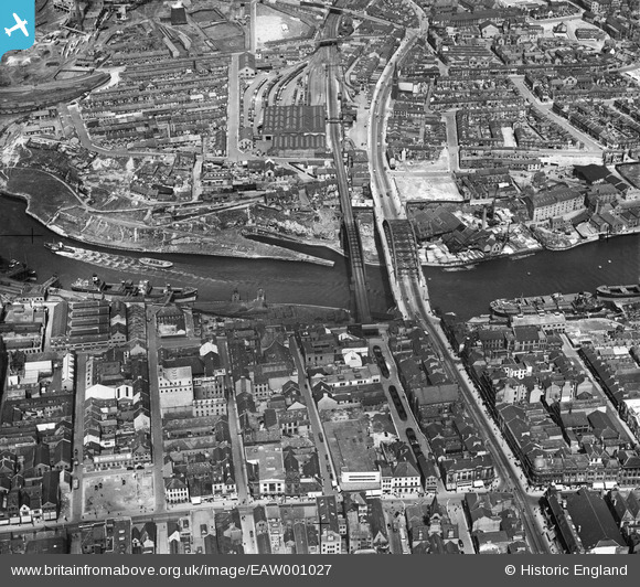
EAW001027 ENGLAND (1946). Wearmouth Bridge and the surrounding industrial and residential area, Sunderland, 1946
© Copyright OpenStreetMap contributors and licensed by the OpenStreetMap Foundation. 2025. Cartography is licensed as CC BY-SA.
Nearby Images (15)
Details
| Title | [EAW001027] Wearmouth Bridge and the surrounding industrial and residential area, Sunderland, 1946 |
| Reference | EAW001027 |
| Date | 6-June-1946 |
| Link | |
| Place name | SUNDERLAND |
| Parish | |
| District | |
| Country | ENGLAND |
| Easting / Northing | 439596, 557423 |
| Longitude / Latitude | -1.3823281297979, 54.90986420585 |
| National Grid Reference | NZ396574 |


![[EAW001027] Wearmouth Bridge and the surrounding industrial and residential area, Sunderland, 1946](http://britainfromabove.org.uk/sites/all/libraries/aerofilms-images/public/100x100/EAW/001/EAW001027.jpg)
![[EPW051127] Wearmouth Bridge and environs, Sunderland, 1936. This image has been produced from copy-negative.](http://britainfromabove.org.uk/sites/all/libraries/aerofilms-images/public/100x100/EPW/051/EPW051127.jpg)
![[EPW020544] The Wearmouth Bridge and Lambton and Hetton Staiths, Sunderland, from the east, 1928](http://britainfromabove.org.uk/sites/all/libraries/aerofilms-images/public/100x100/EPW/020/EPW020544.jpg)
![[EAW001026] Wearmouth Bridge and the surrounding industrial and residential area, Sunderland, 1946](http://britainfromabove.org.uk/sites/all/libraries/aerofilms-images/public/100x100/EAW/001/EAW001026.jpg)
![[EAW001028] Monkwearmouth Goods Station, the River Wear and the surrounding industrial and residential area, Sunderland, 1946](http://britainfromabove.org.uk/sites/all/libraries/aerofilms-images/public/100x100/EAW/001/EAW001028.jpg)
![[EAW405804] Wearmouth Bridge, Sunderland Harbour, Sunderland, 1981](http://britainfromabove.org.uk/sites/all/libraries/aerofilms-images/public/100x100/EAW/405/EAW405804.jpg)
![[EAW021466] The SS Denis being towed along the River Wear, Sunderland, 1949. This image has been produced from a print.](http://britainfromabove.org.uk/sites/all/libraries/aerofilms-images/public/100x100/EAW/021/EAW021466.jpg)
![[EAW021454] SS "Denis" (2) and assisting tugs on the River Wear by Wearmouth Bridge and Monkwearmouth Brewery, Monkwearmouth, 1949](http://britainfromabove.org.uk/sites/all/libraries/aerofilms-images/public/100x100/EAW/021/EAW021454.jpg)
![[EAW022796] The Vaux and Associated Breweries Ltd Brewery on Castle Street, Garrison Field, and Wearmouth Bridge, Sunderland, 1949](http://britainfromabove.org.uk/sites/all/libraries/aerofilms-images/public/100x100/EAW/022/EAW022796.jpg)
![[EAW022795] The Vaux and Associated Breweries Ltd Brewery on Castle Street, Garrison Field, and Wearmouth Bridge, Sunderland, 1949](http://britainfromabove.org.uk/sites/all/libraries/aerofilms-images/public/100x100/EAW/022/EAW022795.jpg)
![[EAW022830] Vaux and Associated Breweries Ltd Brewery, Garrison Field and Wearmouth Bridge, Sunderland, 1949](http://britainfromabove.org.uk/sites/all/libraries/aerofilms-images/public/100x100/EAW/022/EAW022830.jpg)
![[EPW010360] Robson and Sons Ltd Queen Street Mill and the Wearmouth Bridges, Sunderland, 1924. This image has been produced from a copy-negative.](http://britainfromabove.org.uk/sites/all/libraries/aerofilms-images/public/100x100/EPW/010/EPW010360.jpg)
![[EAW022798] The Vaux and Associated Breweries Ltd Brewery on Castle Street and environs, Sunderland, 1949. This image has been produced from a print marked by Aerofilms Ltd for photo editing.](http://britainfromabove.org.uk/sites/all/libraries/aerofilms-images/public/100x100/EAW/022/EAW022798.jpg)
![[EAW021467] The SS Denis being towed along the River Wear, Sunderland, 1949. This image has been produced from a print.](http://britainfromabove.org.uk/sites/all/libraries/aerofilms-images/public/100x100/EAW/021/EAW021467.jpg)
![[EAW022794] The Vaux and Associated Breweries Ltd Brewery on Castle Street, Garrison Field, and Wearmouth Colliery, Sunderland, 1949](http://britainfromabove.org.uk/sites/all/libraries/aerofilms-images/public/100x100/EAW/022/EAW022794.jpg)
