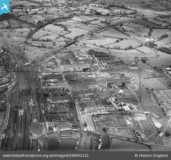
EAW001113 ENGLAND (1946). British Thomson-Houston Electrical Engineering Works, Rugby, 1946
© Copyright OpenStreetMap contributors and licensed by the OpenStreetMap Foundation. 2025. Cartography is licensed as CC BY-SA.
Nearby Images (28)
Details
| Title | [EAW001113] British Thomson-Houston Electrical Engineering Works, Rugby, 1946 |
| Reference | EAW001113 |
| Date | 20-June-1946 |
| Link | |
| Place name | RUGBY |
| Parish | |
| District | |
| Country | ENGLAND |
| Easting / Northing | 450731, 276377 |
| Longitude / Latitude | -1.2545759866521, 52.382692763651 |
| National Grid Reference | SP507764 |
Pins
 Matt Aldred edob.mattaldred.com |
Wednesday 6th of December 2023 02:13:39 PM | |
 Matt Aldred edob.mattaldred.com |
Sunday 28th of February 2021 09:18:54 AM | |
 Matt Aldred edob.mattaldred.com |
Sunday 28th of February 2021 09:18:47 AM | |
 cptpies |
Tuesday 30th of September 2014 09:41:35 AM | |
 Anthony Appleyard |
Wednesday 23rd of October 2013 09:06:52 AM | |
 Anthony Appleyard |
Wednesday 23rd of October 2013 09:05:25 AM | |
 Anthony Appleyard |
Wednesday 23rd of October 2013 09:03:50 AM |
User Comment Contributions
 cptpies |
Tuesday 30th of September 2014 09:42:41 AM |


![[EAW001113] British Thomson-Houston Electrical Engineering Works, Rugby, 1946](http://britainfromabove.org.uk/sites/all/libraries/aerofilms-images/public/100x100/EAW/001/EAW001113.jpg)
![[EAW001114] British Thomson-Houston Electrical Engineering Works, Rugby, 1946](http://britainfromabove.org.uk/sites/all/libraries/aerofilms-images/public/100x100/EAW/001/EAW001114.jpg)
![[EAW001118] British Thomson-Houston Electrical Engineering Works, Rugby, 1946](http://britainfromabove.org.uk/sites/all/libraries/aerofilms-images/public/100x100/EAW/001/EAW001118.jpg)
![[EAW001115] British Thomson-Houston Electrical Engineering Works, Rugby, 1946](http://britainfromabove.org.uk/sites/all/libraries/aerofilms-images/public/100x100/EAW/001/EAW001115.jpg)
![[EAW001112] British Thomson-Houston Electrical Engineering Works, Rugby, 1946](http://britainfromabove.org.uk/sites/all/libraries/aerofilms-images/public/100x100/EAW/001/EAW001112.jpg)
![[EAW001116] British Thomson-Houston Electrical Engineering Works, Rugby, 1946](http://britainfromabove.org.uk/sites/all/libraries/aerofilms-images/public/100x100/EAW/001/EAW001116.jpg)
![[EAW000245] The British Thomson-Houston Electrical Engineering Works, Rugby, 1946](http://britainfromabove.org.uk/sites/all/libraries/aerofilms-images/public/100x100/EAW/000/EAW000245.jpg)
![[EAW000247] The British Thomson-Houston Electrical Engineering Works, Rugby, 1946](http://britainfromabove.org.uk/sites/all/libraries/aerofilms-images/public/100x100/EAW/000/EAW000247.jpg)
![[EPW028220] British Thomson-Houston Electrical Engineering Works, Rugby, 1929](http://britainfromabove.org.uk/sites/all/libraries/aerofilms-images/public/100x100/EPW/028/EPW028220.jpg)
![[EAW000246] The British Thomson-Houston Electrical Engineering Works, Rugby, 1946](http://britainfromabove.org.uk/sites/all/libraries/aerofilms-images/public/100x100/EAW/000/EAW000246.jpg)
![[EPW028215] British Thomson-Houston Electrical Engineering Works, Rugby, 1929](http://britainfromabove.org.uk/sites/all/libraries/aerofilms-images/public/100x100/EPW/028/EPW028215.jpg)
![[EPW028218] British Thomson-Houston Electrical Engineering Works, Rugby, 1929](http://britainfromabove.org.uk/sites/all/libraries/aerofilms-images/public/100x100/EPW/028/EPW028218.jpg)
![[EAW001117] British Thomson-Houston Electrical Engineering Works and environs, Rugby, 1946](http://britainfromabove.org.uk/sites/all/libraries/aerofilms-images/public/100x100/EAW/001/EAW001117.jpg)
![[EAW000239] The British Thomson-Houston Electrical Engineering Works, Rugby, 1946](http://britainfromabove.org.uk/sites/all/libraries/aerofilms-images/public/100x100/EAW/000/EAW000239.jpg)
![[EPW033931] British Thomson-Houston Co Ltd Electrical Engineering Works, Rugby, 1930](http://britainfromabove.org.uk/sites/all/libraries/aerofilms-images/public/100x100/EPW/033/EPW033931.jpg)
![[EPW028222] British Thomson-Houston Electrical Engineering Works, Rugby, 1929](http://britainfromabove.org.uk/sites/all/libraries/aerofilms-images/public/100x100/EPW/028/EPW028222.jpg)
![[EPW028214] British Thomson-Houston Electrical Engineering Works, Rugby, 1929](http://britainfromabove.org.uk/sites/all/libraries/aerofilms-images/public/100x100/EPW/028/EPW028214.jpg)
![[EPW028217] British Thomson-Houston Electrical Engineering Works, Rugby, 1929](http://britainfromabove.org.uk/sites/all/libraries/aerofilms-images/public/100x100/EPW/028/EPW028217.jpg)
![[EAW000244] The British Thomson-Houston Electrical Engineering Works, Rugby, 1946](http://britainfromabove.org.uk/sites/all/libraries/aerofilms-images/public/100x100/EAW/000/EAW000244.jpg)
![[EPW010529] The British Thomson-Houston Electrical Engineering Works, Rugby, 1924](http://britainfromabove.org.uk/sites/all/libraries/aerofilms-images/public/100x100/EPW/010/EPW010529.jpg)
![[EPW028855] The British Thomson-Houston Electrical Engineering Works and environs, Rugby, 1929](http://britainfromabove.org.uk/sites/all/libraries/aerofilms-images/public/100x100/EPW/028/EPW028855.jpg)
![[EPW028852] The British Thomson-Houston Electrical Engineering Works and environs, Rugby, 1929](http://britainfromabove.org.uk/sites/all/libraries/aerofilms-images/public/100x100/EPW/028/EPW028852.jpg)
![[EAW000241] The British Thomson-Houston Electrical Engineering Works, Rugby, 1946](http://britainfromabove.org.uk/sites/all/libraries/aerofilms-images/public/100x100/EAW/000/EAW000241.jpg)
![[EPW028216] British Thomson-Houston Electrical Engineering Works, Rugby, 1929](http://britainfromabove.org.uk/sites/all/libraries/aerofilms-images/public/100x100/EPW/028/EPW028216.jpg)
![[EPW028221] British Thomson-Houston Electrical Engineering Works, Rugby, 1929](http://britainfromabove.org.uk/sites/all/libraries/aerofilms-images/public/100x100/EPW/028/EPW028221.jpg)
![[EAW000243] The British Thomson-Houston Electrical Engineering Works, Rugby, 1946](http://britainfromabove.org.uk/sites/all/libraries/aerofilms-images/public/100x100/EAW/000/EAW000243.jpg)
![[EPW001337] The British Thomson-Houston Company Limited, Rugby, 1920](http://britainfromabove.org.uk/sites/all/libraries/aerofilms-images/public/100x100/EPW/001/EPW001337.jpg)
![[EAW000240] The British Thomson-Houston Electrical Engineering Works, Rugby, 1946](http://britainfromabove.org.uk/sites/all/libraries/aerofilms-images/public/100x100/EAW/000/EAW000240.jpg)
