
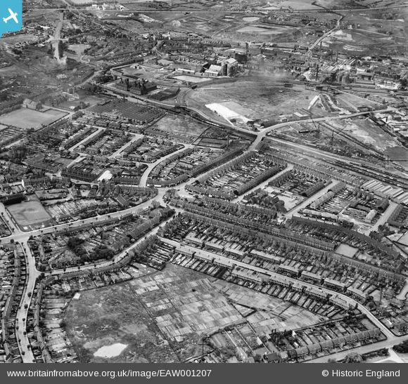
EAW001207 ENGLAND (1946). The industrial and residential area surrounding Tat Bank Road and Apollo Road, Rood End, 1946
© Copyright OpenStreetMap contributors and licensed by the OpenStreetMap Foundation. 2025. Cartography is licensed as CC BY-SA.
Nearby Images (9)
EAW001207

EAW001206

EPW050388

EPW050391

EPW050389

EPW050392

EPW050390

EPW050393

EAW001208

Details
| Title | [EAW001207] The industrial and residential area surrounding Tat Bank Road and Apollo Road, Rood End, 1946 |
| Reference | EAW001207 |
| Date | 24-June-1946 |
| Link | |
| Place name | ROOD END |
| Parish | |
| District | |
| Country | ENGLAND |
| Easting / Northing | 400061, 288534 |
| Longitude / Latitude | -1.9991014247534, 52.494347540738 |
| National Grid Reference | SP001885 |
Pins
 Martin |
Thursday 4th of August 2016 10:21:56 PM | |
Martin |
Thursday 4th of August 2016 10:20:39 PM | |
Stormy78 |
Thursday 24th of July 2014 10:10:03 AM | |
Stormy78 |
Thursday 24th of July 2014 10:08:25 AM | |
kefizz |
Sunday 27th of April 2014 07:34:21 PM | |
kefizz |
Sunday 27th of April 2014 07:27:27 PM | |
Martin |
Wednesday 29th of January 2014 11:59:21 PM | |
Martin |
Wednesday 29th of January 2014 11:58:38 PM | |
Martin |
Wednesday 29th of January 2014 11:55:59 PM | |
Martin |
Wednesday 29th of January 2014 11:54:48 PM | |
Martin |
Wednesday 29th of January 2014 11:53:50 PM | |
Martin |
Saturday 28th of December 2013 09:43:40 PM |