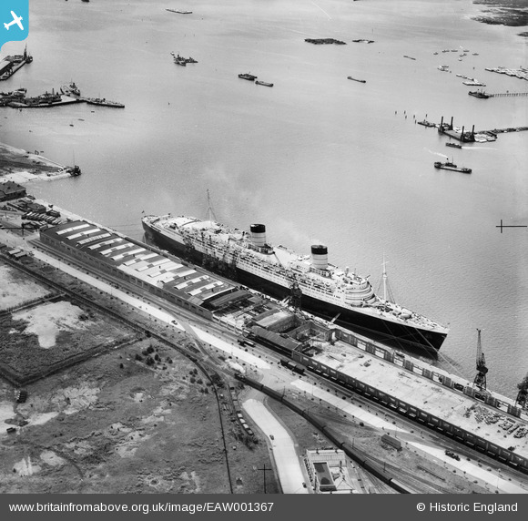
EAW001367 ENGLAND (1946). RMS Queen Elizabeth at the New Docks (Western Docks), Southampton, 1946
© Copyright OpenStreetMap contributors and licensed by the OpenStreetMap Foundation. 2025. Cartography is licensed as CC BY-SA.
Nearby Images (20)
Details
| Title | [EAW001367] RMS Queen Elizabeth at the New Docks (Western Docks), Southampton, 1946 |
| Reference | EAW001367 |
| Date | 28-June-1946 |
| Link | |
| Place name | SOUTHAMPTON |
| Parish | |
| District | |
| Country | ENGLAND |
| Easting / Northing | 441195, 111325 |
| Longitude / Latitude | -1.414130311246, 50.899377913408 |
| National Grid Reference | SU412113 |
Pins
 redmist |
Tuesday 6th of December 2022 07:39:04 PM | |
 redmist |
Tuesday 6th of December 2022 07:36:18 PM | |
 Graham Yaxley |
Monday 5th of January 2015 06:11:17 PM | |
 Graham Yaxley |
Monday 5th of January 2015 06:08:30 PM |


![[EAW001367] RMS Queen Elizabeth at the New Docks (Western Docks), Southampton, 1946](http://britainfromabove.org.uk/sites/all/libraries/aerofilms-images/public/100x100/EAW/001/EAW001367.jpg)
![[EAW035614] The Festival of Britain Exhibition Ship (HMS Campania) moored alongside the Passenger and Goods Shed No 101, Southampton, 1951](http://britainfromabove.org.uk/sites/all/libraries/aerofilms-images/public/100x100/EAW/035/EAW035614.jpg)
![[EAW001364] RMS Queen Elizabeth at the New Docks (Western Docks), Southampton, 1946](http://britainfromabove.org.uk/sites/all/libraries/aerofilms-images/public/100x100/EAW/001/EAW001364.jpg)
![[EAW035612] The Festival of Britain Exhibition Ship (HMS Campania) moored alongside the Passenger and Goods Shed No 101, Southampton, 1951](http://britainfromabove.org.uk/sites/all/libraries/aerofilms-images/public/100x100/EAW/035/EAW035612.jpg)
![[EAW001365] RMS Queen Elizabeth at the New Docks (Western Docks), Southampton, from the south-west, 1946](http://britainfromabove.org.uk/sites/all/libraries/aerofilms-images/public/100x100/EAW/001/EAW001365.jpg)
![[EAW001362] RMS Queen Elizabeth at the New Docks (Western Docks), Southampton, 1946](http://britainfromabove.org.uk/sites/all/libraries/aerofilms-images/public/100x100/EAW/001/EAW001362.jpg)
![[EAW001360] RMS Queen Elizabeth at the New Docks (Western Docks), Southampton, from the north-west, 1946](http://britainfromabove.org.uk/sites/all/libraries/aerofilms-images/public/100x100/EAW/001/EAW001360.jpg)
![[EAW035613] The Festival of Britain Exhibition Ship (HMS Campania) moored alongside the Passenger and Goods Shed No 101, Southampton, 1951](http://britainfromabove.org.uk/sites/all/libraries/aerofilms-images/public/100x100/EAW/035/EAW035613.jpg)
![[EAW035610] The Festival of Britain Exhibition Ship (HMS Campania) moored alongside the Passenger and Goods Shed No 101, Southampton, 1951](http://britainfromabove.org.uk/sites/all/libraries/aerofilms-images/public/100x100/EAW/035/EAW035610.jpg)
![[EAW035611] The Festival of Britain Exhibition Ship (HMS Campania) moored alongside the Passenger and Goods Shed No 101, Southampton, 1951](http://britainfromabove.org.uk/sites/all/libraries/aerofilms-images/public/100x100/EAW/035/EAW035611.jpg)
![[EAW001339] RMS Queen Elizabeth at the New Docks (Western Docks), Southampton, from the south-east, 1946](http://britainfromabove.org.uk/sites/all/libraries/aerofilms-images/public/100x100/EAW/001/EAW001339.jpg)
![[EAW051599] An unidentified Ocean Liner docked alongside No 101 Passenger & Goods Shed, Southampton, from the south, 1953](http://britainfromabove.org.uk/sites/all/libraries/aerofilms-images/public/100x100/EAW/051/EAW051599.jpg)
![[EAW001363] RMS Queen Elizabeth at the New Docks (Western Docks), Southampton, from the south-west, 1946](http://britainfromabove.org.uk/sites/all/libraries/aerofilms-images/public/100x100/EAW/001/EAW001363.jpg)
![[EAW002824] RMS Queen Elizabeth at the New Docks (Western Docks), Southampton, from the south, 1946](http://britainfromabove.org.uk/sites/all/libraries/aerofilms-images/public/100x100/EAW/002/EAW002824.jpg)
![[EAW022290] A Union-Castle Line ship at the New Docks (Western Docks), Southampton, from the south, 1949](http://britainfromabove.org.uk/sites/all/libraries/aerofilms-images/public/100x100/EAW/022/EAW022290.jpg)
![[EPW041062] Reclamation of the Western Docks between Royal Pier and Millbrook, Southampton, 1933](http://britainfromabove.org.uk/sites/all/libraries/aerofilms-images/public/100x100/EPW/041/EPW041062.jpg)
![[EAW001356] RMS Queen Elizabeth at the New Docks (Western Docks), Southampton, from the north-west, 1946](http://britainfromabove.org.uk/sites/all/libraries/aerofilms-images/public/100x100/EAW/001/EAW001356.jpg)
![[EAW001366] RMS Queen Elizabeth at the New Docks (Western Docks), Southampton, 1946](http://britainfromabove.org.uk/sites/all/libraries/aerofilms-images/public/100x100/EAW/001/EAW001366.jpg)
![[EAW001343] RMS Queen Elizabth at the New Docks (Western Docks), Southampton, from the south-east, 1946](http://britainfromabove.org.uk/sites/all/libraries/aerofilms-images/public/100x100/EAW/001/EAW001343.jpg)
![[EAW001353] RMS Queen Elizabeth at the New Docks (Western Docks), Southampton, from the north-west, 1946](http://britainfromabove.org.uk/sites/all/libraries/aerofilms-images/public/100x100/EAW/001/EAW001353.jpg)