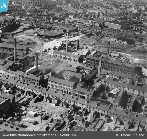
EAW001861 ENGLAND (1946). The Patterson and Stone Warehouse and the surrounding industrial area, Walsall, 1946
© Copyright OpenStreetMap contributors and licensed by the OpenStreetMap Foundation. 2025. Cartography is licensed as CC BY-SA.
Nearby Images (13)
Details
| Title | [EAW001861] The Patterson and Stone Warehouse and the surrounding industrial area, Walsall, 1946 |
| Reference | EAW001861 |
| Date | 12-July-1946 |
| Link | |
| Place name | WALSALL |
| Parish | |
| District | |
| Country | ENGLAND |
| Easting / Northing | 400845, 298544 |
| Longitude / Latitude | -1.9875270433038, 52.584345969226 |
| National Grid Reference | SP008985 |
Pins
 Sparky |
Tuesday 19th of September 2017 09:53:22 PM | |
 kevofbrum |
Sunday 3rd of July 2016 05:08:55 PM | |
 kevofbrum |
Sunday 3rd of July 2016 05:07:57 PM | |
 kevofbrum |
Sunday 3rd of July 2016 05:07:02 PM | |
 kevofbrum |
Sunday 3rd of July 2016 05:06:25 PM | |
 kevofbrum |
Sunday 3rd of July 2016 05:06:07 PM | |
 kevofbrum |
Sunday 3rd of July 2016 05:05:45 PM |


![[EAW001861] The Patterson and Stone Warehouse and the surrounding industrial area, Walsall, 1946](http://britainfromabove.org.uk/sites/all/libraries/aerofilms-images/public/100x100/EAW/001/EAW001861.jpg)
![[EAW001860] The Patterson and Stone Warehouse and the surrounding industrial area, Walsall, 1946](http://britainfromabove.org.uk/sites/all/libraries/aerofilms-images/public/100x100/EAW/001/EAW001860.jpg)
![[EAW001859] The Patterson and Stone Warehouse and the surrounding industrial area, Walsall, 1946](http://britainfromabove.org.uk/sites/all/libraries/aerofilms-images/public/100x100/EAW/001/EAW001859.jpg)
![[EAW001858] The Patterson and Stone Warehouse and the surrounding industrial area, Walsall, 1946](http://britainfromabove.org.uk/sites/all/libraries/aerofilms-images/public/100x100/EAW/001/EAW001858.jpg)
![[EAW001862] The Patterson and Stone Warehouse and the surrounding industrial area, Walsall, 1946](http://britainfromabove.org.uk/sites/all/libraries/aerofilms-images/public/100x100/EAW/001/EAW001862.jpg)
![[EAW001854] The Walsall Leather Dressing Co Works and the surrounding residential area off Frederick Street, Walsall, 1946](http://britainfromabove.org.uk/sites/all/libraries/aerofilms-images/public/100x100/EAW/001/EAW001854.jpg)
![[EAW001855] The Walsall Leather Dressing Co Works and the Kirkpatrick Ltd Iron Foundry off Frederick Street, Walsall, 1946](http://britainfromabove.org.uk/sites/all/libraries/aerofilms-images/public/100x100/EAW/001/EAW001855.jpg)
![[EAW001853] The Walsall Leather Dressing Co Works and the Kirkpatrick Ltd Iron Foundry off Frederick Street, Walsall, 1946](http://britainfromabove.org.uk/sites/all/libraries/aerofilms-images/public/100x100/EAW/001/EAW001853.jpg)
![[EAW001857] The Walsall Leather Dressing Co Works and the surrounding residential area, Walsall, 1946](http://britainfromabove.org.uk/sites/all/libraries/aerofilms-images/public/100x100/EAW/001/EAW001857.jpg)
![[EAW001856] The Walsall Leather Dressing Co Works and the surrounding residential area, Walsall, 1946](http://britainfromabove.org.uk/sites/all/libraries/aerofilms-images/public/100x100/EAW/001/EAW001856.jpg)
![[EPW005671] The Railway Station and Goods Yards, Walsall, 1921](http://britainfromabove.org.uk/sites/all/libraries/aerofilms-images/public/100x100/EPW/005/EPW005671.jpg)
![[EAW039989] The H. W. Lindop and Sons Junction Foundry off Pleck Road and the surrounding area, Walsall, 1951. This image was marked by Aerofilms Ltd for photo editing.](http://britainfromabove.org.uk/sites/all/libraries/aerofilms-images/public/100x100/EAW/039/EAW039989.jpg)
![[EPW024711] Her Majesty's Theatre and environs, Walsall, 1928](http://britainfromabove.org.uk/sites/all/libraries/aerofilms-images/public/100x100/EPW/024/EPW024711.jpg)