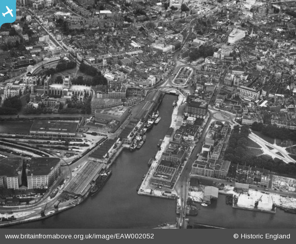
EAW002052 ENGLAND (1946). The Floating Harbour and the Cathedral Church of The Holy and Undivided Trinity, Bristol, 1946. This image has been produced from a print.
© Copyright OpenStreetMap contributors and licensed by the OpenStreetMap Foundation. 2025. Cartography is licensed as CC BY-SA.
Nearby Images (16)
Details
| Title | [EAW002052] The Floating Harbour and the Cathedral Church of The Holy and Undivided Trinity, Bristol, 1946. This image has been produced from a print. |
| Reference | EAW002052 |
| Date | 31-July-1946 |
| Link | |
| Place name | BRISTOL |
| Parish | |
| District | |
| Country | ENGLAND |
| Easting / Northing | 358532, 172632 |
| Longitude / Latitude | -2.5968275046482, 51.450663070703 |
| National Grid Reference | ST585726 |
Pins
 Matt Aldred edob.mattaldred.com |
Friday 8th of March 2024 11:50:56 AM |


![[EAW002052] The Floating Harbour and the Cathedral Church of The Holy and Undivided Trinity, Bristol, 1946. This image has been produced from a print.](http://britainfromabove.org.uk/sites/all/libraries/aerofilms-images/public/100x100/EAW/002/EAW002052.jpg)
![[EPR000106] The Cathedral of The Holy and Undivided Trinity and the city centre, Bristol, 1934](http://britainfromabove.org.uk/sites/all/libraries/aerofilms-images/public/100x100/EPR/000/EPR000106.jpg)
![[EAW002053] The Cathedral Church of The Holy and Undivided Trinity, the Floating Harbour and Queen Square, Bristol, 1946. This image has been produced from a print.](http://britainfromabove.org.uk/sites/all/libraries/aerofilms-images/public/100x100/EAW/002/EAW002053.jpg)
![[EPW012022] The Floating Harbour, Bristol, 1924. This image has been produced from a print.](http://britainfromabove.org.uk/sites/all/libraries/aerofilms-images/public/100x100/EPW/012/EPW012022.jpg)
![[EPW005473] The Cathedral of the Holy and Undivided Trinity, Bristol, 1921](http://britainfromabove.org.uk/sites/all/libraries/aerofilms-images/public/100x100/EPW/005/EPW005473.jpg)
![[EPW005472] The Cathedral of the Holy and Undivided Trinity, Bristol, 1921](http://britainfromabove.org.uk/sites/all/libraries/aerofilms-images/public/100x100/EPW/005/EPW005472.jpg)
![[EPW008828] The Cathedral Church of St Augustine and environs, Bristol, 1923](http://britainfromabove.org.uk/sites/all/libraries/aerofilms-images/public/100x100/EPW/008/EPW008828.jpg)
![[EPW005462] The Cathedral of the Holy and Undivided Trinity, Bristol, 1921](http://britainfromabove.org.uk/sites/all/libraries/aerofilms-images/public/100x100/EPW/005/EPW005462.jpg)
![[EPW033506] Canon's Marsh and environs, Bristol, 1930](http://britainfromabove.org.uk/sites/all/libraries/aerofilms-images/public/100x100/EPW/033/EPW033506.jpg)
![[EPW033503] Queen Square and environs, Bristol, 1930](http://britainfromabove.org.uk/sites/all/libraries/aerofilms-images/public/100x100/EPW/033/EPW033503.jpg)
![[EAW052885] City Hall, the Cathedral Church of The Holy and Undivided Trinity and environs, Bristol, 1953](http://britainfromabove.org.uk/sites/all/libraries/aerofilms-images/public/100x100/EAW/052/EAW052885.jpg)
![[EPW012017] The Cathedral Church of St Augustine, Bristol, 1924. This image has been produced from a print.](http://britainfromabove.org.uk/sites/all/libraries/aerofilms-images/public/100x100/EPW/012/EPW012017.jpg)
![[EPW041479] Canon's Marsh and the city centre, Bristol, from the south, 1933](http://britainfromabove.org.uk/sites/all/libraries/aerofilms-images/public/100x100/EPW/041/EPW041479.jpg)
![[EAW052883] City Hall, the Cathedral Church of The Holy and Undivided Trinity and environs, Bristol, 1953](http://britainfromabove.org.uk/sites/all/libraries/aerofilms-images/public/100x100/EAW/052/EAW052883.jpg)
![[EPW033504] Queen Square and the city, Bristol, from the south-west, 1930](http://britainfromabove.org.uk/sites/all/libraries/aerofilms-images/public/100x100/EPW/033/EPW033504.jpg)
![[EAW026794] The city centre, Bristol, from the south-west, 1949](http://britainfromabove.org.uk/sites/all/libraries/aerofilms-images/public/100x100/EAW/026/EAW026794.jpg)