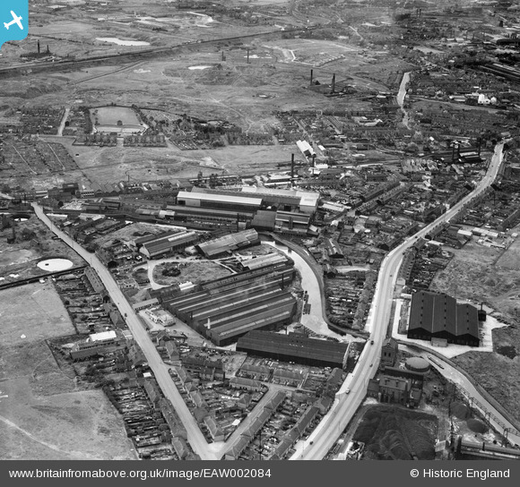
EAW002084 ENGLAND (1946). Swan Village and Ryders Green, West Bromwich, 1946
© Copyright OpenStreetMap contributors and licensed by the OpenStreetMap Foundation. 2024. Cartography is licensed as CC BY-SA.
Nearby Images (16)
Details
| Title | [EAW002084] Swan Village and Ryders Green, West Bromwich, 1946 |
| Reference | EAW002084 |
| Date | 31-July-1946 |
| Link | |
| Place name | WEST BROMWICH |
| Parish | |
| District | |
| Country | ENGLAND |
| Easting / Northing | 398565, 292078 |
| Longitude / Latitude | -2.0211539073311, 52.526209621572 |
| National Grid Reference | SO986921 |
Pins
 redmist |
Sunday 25th of October 2020 04:17:07 PM | |
 redmist |
Sunday 25th of October 2020 04:13:39 PM | |
 redmist |
Sunday 25th of October 2020 04:12:32 PM | |
 redmist |
Sunday 25th of October 2020 04:11:50 PM | |
 redmist |
Sunday 25th of October 2020 04:11:22 PM | |
 redmist |
Sunday 25th of October 2020 04:11:04 PM | |
 redmist |
Sunday 25th of October 2020 04:10:30 PM | |
 redmist |
Sunday 25th of October 2020 04:09:49 PM | |
 redmist |
Sunday 25th of October 2020 04:08:54 PM | |
 redmist |
Sunday 25th of October 2020 04:07:38 PM | |
 redmist |
Sunday 25th of October 2020 04:06:31 PM | |
 redmist |
Sunday 25th of October 2020 04:03:55 PM | |
 redmist |
Sunday 25th of October 2020 04:03:20 PM | |
 Dave York |
Wednesday 19th of October 2016 09:35:59 PM | |
 Martin |
Wednesday 25th of December 2013 12:34:19 PM | |
 Martin |
Wednesday 25th of December 2013 12:25:52 PM | |
 DaveT |
Thursday 5th of December 2013 04:14:38 PM | |
 DaveT |
Thursday 5th of December 2013 04:02:50 PM | |
 DaveT |
Thursday 5th of December 2013 03:56:18 PM | |
 macgoilladubh |
Friday 29th of November 2013 03:08:23 PM | |
 DaveT |
Tuesday 15th of October 2013 12:00:19 PM | |
 DaveT |
Tuesday 15th of October 2013 11:57:22 AM |


![[EAW002084] Swan Village and Ryders Green, West Bromwich, 1946](http://britainfromabove.org.uk/sites/all/libraries/aerofilms-images/public/100x100/EAW/002/EAW002084.jpg)
![[EPW021854] Crown Bridge Works and Staffordshire Edge Tool Works, West Bromwich, 1928](http://britainfromabove.org.uk/sites/all/libraries/aerofilms-images/public/100x100/EPW/021/EPW021854.jpg)
![[EPW021858] Crown Bridge Works and Ryders Green Locks, West Bromwich, 1928](http://britainfromabove.org.uk/sites/all/libraries/aerofilms-images/public/100x100/EPW/021/EPW021858.jpg)
![[EPW021855] Crown Bridge Works and Kingfisher Furniture Works, West Bromwich, 1928](http://britainfromabove.org.uk/sites/all/libraries/aerofilms-images/public/100x100/EPW/021/EPW021855.jpg)
![[EAW002080] The Phoenix Steel Tube Co Works in Swan Village, West Bromwich, 1946](http://britainfromabove.org.uk/sites/all/libraries/aerofilms-images/public/100x100/EAW/002/EAW002080.jpg)
![[EPW021856] Crown Bridge Works, West Bromwich, 1928](http://britainfromabove.org.uk/sites/all/libraries/aerofilms-images/public/100x100/EPW/021/EPW021856.jpg)
![[EPW021859] Crown Bridge Works and Kingfisher Furniture Works, West Bromwich, 1928](http://britainfromabove.org.uk/sites/all/libraries/aerofilms-images/public/100x100/EPW/021/EPW021859.jpg)
![[EAW002082] The Phoenix Steel Tube Co Works in Swan Village, West Bromwich, 1946](http://britainfromabove.org.uk/sites/all/libraries/aerofilms-images/public/100x100/EAW/002/EAW002082.jpg)
![[EPW021857] Crown Bridge Works and Phoenix Iron Foundry, West Bromwich, 1928](http://britainfromabove.org.uk/sites/all/libraries/aerofilms-images/public/100x100/EPW/021/EPW021857.jpg)
![[EPW021851] Crown Bridge Works and Kingfisher Furniture Works, West Bromwich, 1928](http://britainfromabove.org.uk/sites/all/libraries/aerofilms-images/public/100x100/EPW/021/EPW021851.jpg)
![[EAW002077] The Phoenix Steel Tube Co Works in Swan Village, West Bromwich, 1946](http://britainfromabove.org.uk/sites/all/libraries/aerofilms-images/public/100x100/EAW/002/EAW002077.jpg)
![[EAW002083] The Phoenix Steel Tube Co Works in Swan Village, West Bromwich, 1946](http://britainfromabove.org.uk/sites/all/libraries/aerofilms-images/public/100x100/EAW/002/EAW002083.jpg)
![[EAW002079] The Phoenix Steel Tube Co Works in Swan Village, West Bromwich, 1946](http://britainfromabove.org.uk/sites/all/libraries/aerofilms-images/public/100x100/EAW/002/EAW002079.jpg)
![[EAW002078] A new commercial building on the site of Swan Farm, West Bromwich, 1946](http://britainfromabove.org.uk/sites/all/libraries/aerofilms-images/public/100x100/EAW/002/EAW002078.jpg)
![[EAW002081] A new commercial building on the site of Swan Farm, West Bromwich, 1946](http://britainfromabove.org.uk/sites/all/libraries/aerofilms-images/public/100x100/EAW/002/EAW002081.jpg)
![[EAW002086] The Phoenix Steel Tube Co Works in Swan Village, West Bromwich, 1946](http://britainfromabove.org.uk/sites/all/libraries/aerofilms-images/public/100x100/EAW/002/EAW002086.jpg)