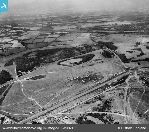
EAW002165 ENGLAND (1946). Epsom Downs, The City and Surburban Race Meeting, from the north-east, 1946
© Copyright OpenStreetMap contributors and licensed by the OpenStreetMap Foundation. 2025. Cartography is licensed as CC BY-SA.
Nearby Images (38)
Details
| Title | [EAW002165] Epsom Downs, The City and Surburban Race Meeting, from the north-east, 1946 |
| Reference | EAW002165 |
| Date | 5-August-1946 |
| Link | |
| Place name | EPSOM DOWNS |
| Parish | |
| District | |
| Country | ENGLAND |
| Easting / Northing | 521905, 158374 |
| Longitude / Latitude | -0.25076764204585, 51.310900557597 |
| National Grid Reference | TQ219584 |
Pins
Be the first to add a comment to this image!


![[EAW002165] Epsom Downs, The City and Surburban Race Meeting, from the north-east, 1946](http://britainfromabove.org.uk/sites/all/libraries/aerofilms-images/public/100x100/EAW/002/EAW002165.jpg)
![[EAW000991] Epsom Downs, crowds at the Epsom Race Course Victory Derby, from the south, 1946. This image has been produced from a damaged negative.](http://britainfromabove.org.uk/sites/all/libraries/aerofilms-images/public/100x100/EAW/000/EAW000991.jpg)
![[EAW002167] Epsom Downs, The City and Surburban Race Meeting, from the north, 1946](http://britainfromabove.org.uk/sites/all/libraries/aerofilms-images/public/100x100/EAW/002/EAW002167.jpg)
![[EPW025147] The Epsom Downs Race Course and Grand Stand, Epsom Downs, from the south-east, 1928](http://britainfromabove.org.uk/sites/all/libraries/aerofilms-images/public/100x100/EPW/025/EPW025147.jpg)
![[EPW027457] Epsom Downs, Derby Day, 1929](http://britainfromabove.org.uk/sites/all/libraries/aerofilms-images/public/100x100/EPW/027/EPW027457.jpg)
![[EAW017627] Fairground at Epsom Racecourse, Epsom Downs, 1948. This image has been produced from a print.](http://britainfromabove.org.uk/sites/all/libraries/aerofilms-images/public/100x100/EAW/017/EAW017627.jpg)
![[EPW007653] The Home Straight at Epsom Racecourse, Epsom, from the east, 1922](http://britainfromabove.org.uk/sites/all/libraries/aerofilms-images/public/100x100/EPW/007/EPW007653.jpg)
![[EAW002166] Epsom Downs, The City and Surburban Race Meeting, 1946](http://britainfromabove.org.uk/sites/all/libraries/aerofilms-images/public/100x100/EAW/002/EAW002166.jpg)
![[EPW025144] The Epsom Downs Race Course Grand Stand, Epsom Downs, from the south-east, 1928](http://britainfromabove.org.uk/sites/all/libraries/aerofilms-images/public/100x100/EPW/025/EPW025144.jpg)
![[EPW006391] Epsom Downs, Derby Day at Epsom Racecourse, 1921. This image has been produced from a print.](http://britainfromabove.org.uk/sites/all/libraries/aerofilms-images/public/100x100/EPW/006/EPW006391.jpg)
![[EPW006431] Epsom Downs, Derby Day crowds at Epsom Racecourse, 1921. This image has been produced from a print.](http://britainfromabove.org.uk/sites/all/libraries/aerofilms-images/public/100x100/EPW/006/EPW006431.jpg)
![[EPW025158] Epsom Downs Race Course and Grand Stand, Epsom Downs, from the south-east, 1928](http://britainfromabove.org.uk/sites/all/libraries/aerofilms-images/public/100x100/EPW/025/EPW025158.jpg)
![[EAW049499] Epsom Downs Racecourse, Epsom, 1953](http://britainfromabove.org.uk/sites/all/libraries/aerofilms-images/public/100x100/EAW/049/EAW049499.jpg)
![[EPW006380] Epsom Racecourse, Epsom Downs, 1921](http://britainfromabove.org.uk/sites/all/libraries/aerofilms-images/public/100x100/EPW/006/EPW006380.jpg)
![[EAW017626] Racecourse tents and the Grandstand at Epsom Racecourse, Epsom Downs, 1948. This image has been produced from a print.](http://britainfromabove.org.uk/sites/all/libraries/aerofilms-images/public/100x100/EAW/017/EAW017626.jpg)
![[EPW035515] Epsom Downs, Derby Day, 1931](http://britainfromabove.org.uk/sites/all/libraries/aerofilms-images/public/100x100/EPW/035/EPW035515.jpg)
![[EPW006387] Epsom Racecourse, Epsom Downs, 1921](http://britainfromabove.org.uk/sites/all/libraries/aerofilms-images/public/100x100/EPW/006/EPW006387.jpg)
![[EPW007900] Epsom Racecourse, Epsom Downs, 1922](http://britainfromabove.org.uk/sites/all/libraries/aerofilms-images/public/100x100/EPW/007/EPW007900.jpg)
![[EPW006369] Epsom Racecourse, Epsom Downs, 1921](http://britainfromabove.org.uk/sites/all/libraries/aerofilms-images/public/100x100/EPW/006/EPW006369.jpg)
![[EPW006382] Epsom Racecourse, Epsom Downs, from the east, 1921](http://britainfromabove.org.uk/sites/all/libraries/aerofilms-images/public/100x100/EPW/006/EPW006382.jpg)
![[EPW008663] Temporary booths for race day, Epsom, 1923](http://britainfromabove.org.uk/sites/all/libraries/aerofilms-images/public/100x100/EPW/008/EPW008663.jpg)
![[EPW006364] Epsom Racecourse, Epsom Downs, from the north-east, 1921](http://britainfromabove.org.uk/sites/all/libraries/aerofilms-images/public/100x100/EPW/006/EPW006364.jpg)
![[EAW017624] The Grandstand at Epsom Racecourse, Epsom Downs, from the south, 1948. This image has been produced from a print.](http://britainfromabove.org.uk/sites/all/libraries/aerofilms-images/public/100x100/EAW/017/EAW017624.jpg)
![[EAW043433] Epsom Downs, Derby Day at Epsom Racecourse, 1952](http://britainfromabove.org.uk/sites/all/libraries/aerofilms-images/public/100x100/EAW/043/EAW043433.jpg)
![[EAW024759] Epsom Racecourse, Epsom Downs, 1949](http://britainfromabove.org.uk/sites/all/libraries/aerofilms-images/public/100x100/EAW/024/EAW024759.jpg)
![[EPW006482] Epsom Racecourse on Derby Day, Epsom Downs, 1921](http://britainfromabove.org.uk/sites/all/libraries/aerofilms-images/public/100x100/EPW/006/EPW006482.jpg)
![[EPW027459] Epsom Downs, Derby Day, 1929](http://britainfromabove.org.uk/sites/all/libraries/aerofilms-images/public/100x100/EPW/027/EPW027459.jpg)
![[EPW007650] The Grandstand at Epsom Racecourse, Epsom, 1922](http://britainfromabove.org.uk/sites/all/libraries/aerofilms-images/public/100x100/EPW/007/EPW007650.jpg)
![[EAW000990] Epsom Downs, crowds at the Epsom Race Course Victory Derby, from the south, 1946. This image has been produced from a damaged negative.](http://britainfromabove.org.uk/sites/all/libraries/aerofilms-images/public/100x100/EAW/000/EAW000990.jpg)
![[EPW007902] The grandstand at Epsom Racecourse, Epsom Downs, 1922](http://britainfromabove.org.uk/sites/all/libraries/aerofilms-images/public/100x100/EPW/007/EPW007902.jpg)
![[EPW025156] Epsom Downs Race Course and Grand Stand, Epsom Downs, 1928](http://britainfromabove.org.uk/sites/all/libraries/aerofilms-images/public/100x100/EPW/025/EPW025156.jpg)
![[EPW025150] The Epsom Downs Race Course Grand Stand and Prince's Stand, Epsom Downs, 1928](http://britainfromabove.org.uk/sites/all/libraries/aerofilms-images/public/100x100/EPW/025/EPW025150.jpg)
![[EPW007652] The Grandstand at Epsom Racecourse, Epsom, 1922](http://britainfromabove.org.uk/sites/all/libraries/aerofilms-images/public/100x100/EPW/007/EPW007652.jpg)
![[EPW006441] Epsom Racecourse on Derby Day, Epsom Downs, 1921](http://britainfromabove.org.uk/sites/all/libraries/aerofilms-images/public/100x100/EPW/006/EPW006441.jpg)
![[EPW025140] Epsom Downs Race Course, Epsom Downs, from the south-west, 1928](http://britainfromabove.org.uk/sites/all/libraries/aerofilms-images/public/100x100/EPW/025/EPW025140.jpg)
![[EPW025157] Epsom Downs Race Course and Grand Stand, Epsom Downs, 1928](http://britainfromabove.org.uk/sites/all/libraries/aerofilms-images/public/100x100/EPW/025/EPW025157.jpg)
![[EPW017555] The Epsom racecourse grandstand under construction, Epsom Downs, 1927. This image was marked by Aerofilms Ltd for photo editing.](http://britainfromabove.org.uk/sites/all/libraries/aerofilms-images/public/100x100/EPW/017/EPW017555.jpg)
![[EPW008703] The Grandstand and Home Straight, Epsom, 1923](http://britainfromabove.org.uk/sites/all/libraries/aerofilms-images/public/100x100/EPW/008/EPW008703.jpg)