
EAW002518 ENGLAND (1946). Baguley Sanatorium and environs, Baguley, 1946
© Copyright OpenStreetMap contributors and licensed by the OpenStreetMap Foundation. 2025. Cartography is licensed as CC BY-SA.
Nearby Images (6)
EAW002518

EPW016732

EAW002520

EAW002517

EAW002519

EAW002516
 Hospital, Baguley, 1946")
Details
| Title | [EAW002518] Baguley Sanatorium and environs, Baguley, 1946 |
| Reference | EAW002518 |
| Date | 10-September-1946 |
| Link | |
| Place name | BAGULEY |
| Parish | |
| District | |
| Country | ENGLAND |
| Easting / Northing | 380613, 387939 |
| Longitude / Latitude | -2.291528511703, 53.387673124595 |
| National Grid Reference | SJ806879 |
Pins
 Chris Bowden |
Tuesday 7th of July 2020 01:48:03 PM | |
Chris Bowden |
Tuesday 7th of July 2020 01:46:03 PM | |
Chris Bowden |
Tuesday 7th of July 2020 01:43:56 PM | |
 Jan H |
Thursday 19th of September 2019 06:54:11 PM | |
John Ellis |
Sunday 12th of January 2014 10:58:28 AM | |
John Ellis |
Sunday 12th of January 2014 10:55:12 AM | |
John Ellis |
Sunday 12th of January 2014 10:53:18 AM | |
John Ellis |
Sunday 12th of January 2014 10:42:00 AM | |
John Ellis |
Friday 20th of December 2013 07:26:09 PM | |
John Ellis |
Friday 20th of December 2013 07:24:59 PM | |
John Ellis |
Friday 20th of December 2013 07:24:31 PM | |
John Ellis |
Friday 20th of December 2013 07:23:23 PM | |
John Ellis |
Friday 20th of December 2013 07:20:39 PM | |
John Ellis |
Friday 20th of December 2013 07:18:28 PM | |
John Ellis |
Friday 20th of December 2013 07:15:50 PM | |
John Ellis |
Friday 20th of December 2013 07:14:25 PM | |
John Ellis |
Friday 20th of December 2013 07:10:51 PM | |
John Ellis |
Friday 20th of December 2013 07:09:16 PM | |
Recently passing this way for the first time in quite a while, I noticed that the old congregational church now seems to have vanished, along with the nearby last remaining traces of the former junction of Floats Road with Altrincham Road. |
John Ellis |
Tuesday 14th of January 2014 03:19:53 PM |
John Ellis |
Friday 20th of December 2013 07:04:21 PM | |
John Ellis |
Friday 20th of December 2013 07:03:24 PM | |
John Ellis |
Friday 20th of December 2013 07:02:09 PM | |
John Ellis |
Friday 20th of December 2013 07:01:18 PM | |
John Ellis |
Friday 20th of December 2013 06:58:43 PM | |
John Ellis |
Friday 20th of December 2013 06:58:08 PM | |
John Ellis |
Friday 20th of December 2013 06:56:14 PM | |
John Ellis |
Friday 20th of December 2013 06:55:28 PM | |
John Ellis |
Friday 20th of December 2013 06:54:39 PM | |
John Ellis |
Friday 20th of December 2013 06:53:19 PM | |
John Ellis |
Friday 20th of December 2013 06:50:28 PM | |
John Ellis |
Friday 20th of December 2013 06:48:29 PM | |
This peg is a bit misplaced, which I noticed only after the option to remove and "redo" the comment was past. It should be a bit lower and to the south, pointing to the properties between the A560 Altrincham Road and the railway line. |
John Ellis |
Sunday 12th of January 2014 10:46:30 AM |
John Ellis |
Friday 20th of December 2013 06:47:20 PM | |
John Ellis |
Friday 20th of December 2013 06:43:56 PM | |
John Ellis |
Friday 20th of December 2013 06:42:28 PM | |
John Ellis |
Friday 20th of December 2013 06:41:13 PM | |
John Ellis |
Friday 20th of December 2013 06:40:11 PM | |
John Ellis |
Friday 20th of December 2013 06:38:22 PM | |
John Ellis |
Friday 20th of December 2013 06:37:00 PM | |
John Ellis |
Friday 20th of December 2013 06:34:31 PM | |
John Ellis |
Friday 20th of December 2013 06:32:25 PM | |
John Ellis |
Friday 20th of December 2013 06:32:03 PM | |
John Ellis |
Friday 20th of December 2013 06:31:32 PM | |
John Ellis |
Friday 20th of December 2013 06:30:41 PM | |
John Ellis |
Friday 20th of December 2013 06:29:51 PM | |
John Ellis |
Friday 20th of December 2013 06:28:56 PM |
User Comment Contributions
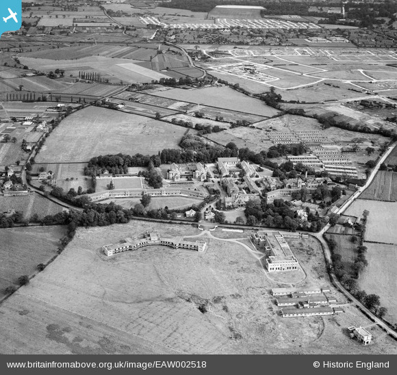
 Despite post-war shortages of materials and restrictions on building, work on the Wythenshawe estate housing project quickly resumed after the end of the war. At its top right corner, this 1946 photograph catches the laying out of roads (Floatshall and Bowland Roads and their sideshoots) in readiness for new housing on Baguley farmland between Floats Road and Hall Lane, across the railway from the pre-war Royal Oak estate; and, further north, the construction of temporary prefab bungalows on the land of Sycamore Farm, between the A560 Altrincham Road and the wooded western fringes of Wythenshawe Park. Image EPW017426 shows much of the same tract of country as it was twenty years earlier, before any significant development had taken place. The post-war council houses that would be built on these new roads perhaps lacked the charm and variety in design of Barry Parker's pre-war estates, but the policy of tree-planting and creating abundant green space was continued. Amenities, however, were for long in distinctly short supply: other than small local shopping parades, pubs, clubs and churches, there was little to break up or give shape to the miles of remarkably similar and rather featureless streets and houses. And the absence of good rail links and Manchester Corporation Transport's almost total monopoly of local bus services meant that it was impossible to travel conveniently and easily by public transport to anywhere other than central Manchester - even though that involved a twenty mile round trip from Wythenshawe's southernmost estates. But the environment was at least open, pleasant, and considerably cleaner than the packed terraced housing of the 19th century inner-city suburbs which it replaced, and the Wythenshawe estate was pretty much complete by the time the 1960s fashion for municipal architectural brutalism came in. However Wythenshawe hasn't been entirely spared. In particular, parts of the industrial areas have been developed and redeveloped several times, not always with attractive results. And Southmoor Road - which roughly follows the course of the now vanished northern section of Floats Road around Floats Hall on this shot - is as hideous a bit of modern roadscape as you could find anywhere, with charmless geometrical industrial units on its western side and, currently under construction on the former grass verges of its eastern side, the bleak steel and concrete of the Metrolink tramway to the airport. |
John Ellis |
Sunday 12th of January 2014 07:09:05 PM |