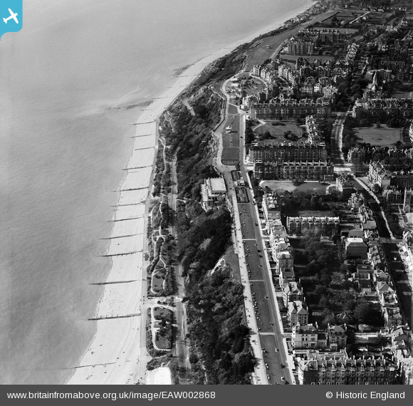
EAW002868 ENGLAND (1946). Housing off The Leas, West Cliff and the seafront, Folkestone, 1946
© Copyright OpenStreetMap contributors and licensed by the OpenStreetMap Foundation. 2025. Cartography is licensed as CC BY-SA.
Nearby Images (15)
Details
| Title | [EAW002868] Housing off The Leas, West Cliff and the seafront, Folkestone, 1946 |
| Reference | EAW002868 |
| Date | 1-October-1946 |
| Link | |
| Place name | FOLKESTONE |
| Parish | FOLKESTONE |
| District | |
| Country | ENGLAND |
| Easting / Northing | 622418, 135514 |
| Longitude / Latitude | 1.1755038670263, 51.075243497563 |
| National Grid Reference | TR224355 |
Pins
 Chris Kolonko |
Saturday 16th of September 2017 08:40:21 PM |


![[EAW002868] Housing off The Leas, West Cliff and the seafront, Folkestone, 1946](http://britainfromabove.org.uk/sites/all/libraries/aerofilms-images/public/100x100/EAW/002/EAW002868.jpg)
![[EAW002856] Housing off The Leas, West Cliff and the seafront, Folkestone, 1946](http://britainfromabove.org.uk/sites/all/libraries/aerofilms-images/public/100x100/EAW/002/EAW002856.jpg)
![[EAW024827] Leas Cliff Hall, Folkestone, 1949](http://britainfromabove.org.uk/sites/all/libraries/aerofilms-images/public/100x100/EAW/024/EAW024827.jpg)
![[EPW000074] Leas Cliff Hall on West Cliff, Folkestone, from the south, 1920](http://britainfromabove.org.uk/sites/all/libraries/aerofilms-images/public/100x100/EPW/000/EPW000074.jpg)
![[EAW002857] Housing off The Leas and Sandgate Road and the seafront, Folkestone, 1946](http://britainfromabove.org.uk/sites/all/libraries/aerofilms-images/public/100x100/EAW/002/EAW002857.jpg)
![[EAW002867] West Cliff, Clifton Crescent and the surrounding coastline, Folkestone, from the east, 1946](http://britainfromabove.org.uk/sites/all/libraries/aerofilms-images/public/100x100/EAW/002/EAW002867.jpg)
![[EPW009199] The Langhorne Gardens and The Leas, Folkestone, 1923](http://britainfromabove.org.uk/sites/all/libraries/aerofilms-images/public/100x100/EPW/009/EPW009199.jpg)
![[EPW035414] West Cliff, Clifton Gardens and the town, Folkestone, from the south, 1931](http://britainfromabove.org.uk/sites/all/libraries/aerofilms-images/public/100x100/EPW/035/EPW035414.jpg)
![[EPW009197] The Clifton Gardens and The Leas, Folkestone, 1923](http://britainfromabove.org.uk/sites/all/libraries/aerofilms-images/public/100x100/EPW/009/EPW009197.jpg)
![[EAW024830] West Cliff, Folkestone, from the south-west, 1949](http://britainfromabove.org.uk/sites/all/libraries/aerofilms-images/public/100x100/EAW/024/EAW024830.jpg)
![[EAW002855] Leas Cliff Hall, Clifton Gardens and the surrounding residential area, Folkestone, 1946](http://britainfromabove.org.uk/sites/all/libraries/aerofilms-images/public/100x100/EAW/002/EAW002855.jpg)
![[EAW024828] The bandstand and the Pulhamite Rock Garden on the Leas, Folkestone, 1949](http://britainfromabove.org.uk/sites/all/libraries/aerofilms-images/public/100x100/EAW/024/EAW024828.jpg)
![[EPW035409] Victoria Pier, West Cliff and the town, Folkestone, 1931](http://britainfromabove.org.uk/sites/all/libraries/aerofilms-images/public/100x100/EPW/035/EPW035409.jpg)
![[EPW009201] Clifton Gardens and The Leas, Folkestone, 1923](http://britainfromabove.org.uk/sites/all/libraries/aerofilms-images/public/100x100/EPW/009/EPW009201.jpg)
![[EAW002370] The area between Clifton Gardens and Radnor Park, Folkestone, from the south, 1946](http://britainfromabove.org.uk/sites/all/libraries/aerofilms-images/public/100x100/EAW/002/EAW002370.jpg)