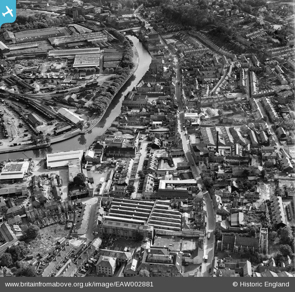
EAW002881 ENGLAND (1946). The Morgans Old Brewery off King Street, the River Wensum and the surrounding area, Norwich, 1946
© Copyright OpenStreetMap contributors and licensed by the OpenStreetMap Foundation. 2025. Cartography is licensed as CC BY-SA.
Nearby Images (9)
Details
| Title | [EAW002881] The Morgans Old Brewery off King Street, the River Wensum and the surrounding area, Norwich, 1946 |
| Reference | EAW002881 |
| Date | 1-October-1946 |
| Link | |
| Place name | NORWICH |
| Parish | |
| District | |
| Country | ENGLAND |
| Easting / Northing | 623558, 308232 |
| Longitude / Latitude | 1.3034824734594, 52.625380239507 |
| National Grid Reference | TG236082 |
Pins
 fatty28uk |
Monday 24th of February 2014 07:19:54 PM | |
 fatty28uk |
Monday 24th of February 2014 07:19:02 PM | |
 fatty28uk |
Monday 24th of February 2014 07:13:10 PM | |
 fatty28uk |
Monday 24th of February 2014 07:10:48 PM | |
 fatty28uk |
Monday 24th of February 2014 07:09:01 PM | |
 fatty28uk |
Monday 24th of February 2014 07:08:20 PM | |
 fatty28uk |
Monday 24th of February 2014 07:07:31 PM | |
 fatty28uk |
Monday 24th of February 2014 07:06:01 PM |


![[EAW002881] The Morgans Old Brewery off King Street, the River Wensum and the surrounding area, Norwich, 1946](http://britainfromabove.org.uk/sites/all/libraries/aerofilms-images/public/100x100/EAW/002/EAW002881.jpg)
![[EAW002885] The Morgans Old Brewery off King Street, the River Wensum and Norwich Railway Station, Norwich, 1946](http://britainfromabove.org.uk/sites/all/libraries/aerofilms-images/public/100x100/EAW/002/EAW002885.jpg)
![[EAW002882] The Morgans Old Brewery off King Street, the River Wensum and Norwich Railway Station, Norwich, 1946](http://britainfromabove.org.uk/sites/all/libraries/aerofilms-images/public/100x100/EAW/002/EAW002882.jpg)
![[EAW002883] The Morgans Old Brewery off King Street, St Peter's Church and the surrounding area, Norwich, 1946](http://britainfromabove.org.uk/sites/all/libraries/aerofilms-images/public/100x100/EAW/002/EAW002883.jpg)
![[EAW002878] The Morgans Old Brewery off King Street and the surrounding area, Norwich, 1946](http://britainfromabove.org.uk/sites/all/libraries/aerofilms-images/public/100x100/EAW/002/EAW002878.jpg)
![[EAW002880] The Morgans Old Brewery off King Street and the surrounding area, Norwich, 1946](http://britainfromabove.org.uk/sites/all/libraries/aerofilms-images/public/100x100/EAW/002/EAW002880.jpg)
![[EAW002884] The Morgans Old Brewery off King Street and the surrounding area, Norwich, 1946](http://britainfromabove.org.uk/sites/all/libraries/aerofilms-images/public/100x100/EAW/002/EAW002884.jpg)
![[EAW002879] The Morgans Old Brewery off King Street, Norwich Castle and the surrounding area, Norwich, 1946](http://britainfromabove.org.uk/sites/all/libraries/aerofilms-images/public/100x100/EAW/002/EAW002879.jpg)
![[EPW001970] General view of the town centre, Norwich, from the south-west, 1920](http://britainfromabove.org.uk/sites/all/libraries/aerofilms-images/public/100x100/EPW/001/EPW001970.jpg)